Category:Austerfield
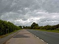
English: Austerfield is a village and civil parish in the Metropolitan Borough of Doncaster (part of South Yorkshire, England), on the border with Nottinghamshire. It lies to the north-east of Bawtry on the A614 road to Finningley, and is located at 53° 26' 30" North, 1° 0' West, at an elevation of around 7 metres above sea level. It is close to the River Idle, and has a population of 571.
Nederlands: Austerfield is een plaats in het bestuurlijke gebied Doncaster, in het Engelse graafschap South Yorkshire.
village in the United Kingdom  L'église paroissiale Sainte-Hélène. | |||||
| Upload media | |||||
| Instance of | |||||
|---|---|---|---|---|---|
| Location | Doncaster, South Yorkshire, Yorkshire and the Humber, England | ||||
| Population |
| ||||
| Area |
| ||||
| official website | |||||
 | |||||
Subcategories
This category has the following 3 subcategories, out of 3 total.
Media in category "Austerfield"
The following 139 files are in this category, out of 139 total.
-
 A flooded Kings Wood car park entrance - geograph.org.uk - 920473.jpg 640 × 480; 121 KB
-
 A614 approaching roundabout - geograph.org.uk - 4047740.jpg 640 × 480; 55 KB
-
 A614 heading east - geograph.org.uk - 4047726.jpg 640 × 480; 57 KB
-
 A614 heading north - geograph.org.uk - 4047729.jpg 640 × 480; 68 KB
-
 A614 heading north - geograph.org.uk - 4047736.jpg 640 × 480; 46 KB
-
 A614 heading north east - geograph.org.uk - 4047750.jpg 640 × 480; 54 KB
-
 A614 towards Thorne - geograph.org.uk - 4047749.jpg 640 × 480; 55 KB
-
 A638 towards Bawtry - geograph.org.uk - 2556499.jpg 1,600 × 1,200; 464 KB
-
 A638 towards Bawtry - geograph.org.uk - 2556539.jpg 1,600 × 1,200; 407 KB
-
 A638 towards Bawtry - geograph.org.uk - 2556552.jpg 1,600 × 1,200; 334 KB
-
 Alongside King's Wood - geograph.org.uk - 3068263.jpg 1,024 × 768; 202 KB
-
 At the southern end of the runway - geograph.org.uk - 4863809.jpg 4,925 × 3,673; 4.07 MB
-
 Austerfield Car Dealership - geograph.org.uk - 1326904.jpg 640 × 480; 67 KB
-
 Austerfield Field Study Centre - geograph.org.uk - 3068281.jpg 1,024 × 768; 151 KB
-
 Austerfield Quarry - geograph.org.uk - 5229425.jpg 800 × 600; 148 KB
-
 Axholme Interiors - geograph.org.uk - 338084.jpg 640 × 427; 65 KB
-
 Bawtry Carbon plant, Austerfield - geograph.org.uk - 5227265.jpg 5,256 × 2,792; 2.13 MB
-
 Bawtry Forest - geograph.org.uk - 2556514.jpg 1,600 × 1,200; 721 KB
-
 Caravan sales centre - geograph.org.uk - 2556510.jpg 1,600 × 1,200; 479 KB
-
 Coffee Shop, Sales Centre and Sculptures - geograph.org.uk - 5157025.jpg 4,455 × 3,248; 3.29 MB
-
 Crop field and woodland - geograph.org.uk - 4047735.jpg 640 × 480; 64 KB
-
 Crop field east of the A614 - geograph.org.uk - 4047738.jpg 640 × 480; 64 KB
-
 Cross Lane - geograph.org.uk - 5226549.jpg 5,376 × 3,024; 2.85 MB
-
 Disused sand and gravel quarry - geograph.org.uk - 1395413.jpg 640 × 389; 59 KB
-
 Don't leave it to someone else - geograph.org.uk - 503637.jpg 640 × 438; 74 KB
-

-
 Emergency Access 2, Robin Hood Airport - geograph.org.uk - 5226554.jpg 5,324 × 2,627; 1.83 MB
-
 Entering Nottinghamshire - geograph.org.uk - 4047753.jpg 640 × 480; 69 KB
-
 Entrance to Bawtry Golf Club - geograph.org.uk - 5226546.jpg 5,376 × 3,024; 2.81 MB
-
 Entrance to RSPCA Centre - geograph.org.uk - 5157047.jpg 4,608 × 3,456; 3.92 MB
-
 Evidence that Tour de Yorkshire came through here - geograph.org.uk - 5227270.jpg 5,310 × 2,900; 1.74 MB
-
 Farm buildings at Austerfield - geograph.org.uk - 3082085.jpg 800 × 600; 89 KB
-
 Farm track Finningley Park - geograph.org.uk - 2556474.jpg 1,600 × 1,200; 345 KB
-
 Farm track towards High Common Lane - geograph.org.uk - 2556494.jpg 1,600 × 1,200; 511 KB
-
 Farmland near Robin Hood Airport - geograph.org.uk - 2556456.jpg 1,600 × 1,200; 589 KB
-
 Farmland near Woodhouse Farm - geograph.org.uk - 2556521.jpg 1,600 × 1,200; 303 KB
-
 Farmland off the A638 - geograph.org.uk - 2556503.jpg 1,600 × 1,200; 476 KB
-
 Farmland, Finningley Park - geograph.org.uk - 2556478.jpg 1,600 × 1,200; 256 KB
-
 Field entrance off the A614 - geograph.org.uk - 4047723.jpg 640 × 480; 72 KB
-
 Field of Maize - geograph.org.uk - 5157052.jpg 4,608 × 3,456; 3.75 MB
-
 Finningley area, aerial 2014 - geograph.org.uk - 3879706.jpg 640 × 427; 52 KB
-
 Finningley Quarry, aerial 2014 - geograph.org.uk - 3879769.jpg 640 × 427; 42 KB
-
 Floodbank near Newington - geograph.org.uk - 5077142.jpg 1,024 × 768; 223 KB
-
 Flooding at Bawtry Carr - geograph.org.uk - 4795896.jpg 4,538 × 3,319; 3.12 MB
-
 Fly tipping is illegal - geograph.org.uk - 1061636.jpg 640 × 356; 45 KB
-
 Footpath and Stile near Austerfield - geograph.org.uk - 4798275.jpg 4,608 × 3,456; 3.74 MB
-
 Footpath beside woodland - geograph.org.uk - 2556464.jpg 1,600 × 1,200; 720 KB
-
 Footpath in Kings Wood - geograph.org.uk - 5229410.jpg 800 × 600; 212 KB
-
 Footpath in Kings Wood - geograph.org.uk - 5229414.jpg 800 × 600; 212 KB
-
 Footpath in Kings Wood - geograph.org.uk - 5995042.jpg 1,024 × 683; 325 KB
-
 Footpath, Fields and Footbridge at Low Common - geograph.org.uk - 4798266.jpg 4,608 × 3,456; 3.55 MB
-
 Former sand pit - geograph.org.uk - 4306697.jpg 1,024 × 768; 166 KB
-
 Former sandpit off Highfield Lane - geograph.org.uk - 3068239.jpg 1,024 × 768; 205 KB
-
 Hanson's sand pit - geograph.org.uk - 5226562.jpg 5,376 × 3,024; 2.75 MB
-
 High Common Lane - geograph.org.uk - 1061630.jpg 640 × 480; 66 KB
-
 High Common Lane - geograph.org.uk - 4047744.jpg 640 × 480; 57 KB
-
 High Common Lane - geograph.org.uk - 4047746.jpg 640 × 480; 71 KB
-
 High Common Lane and pull-in - geograph.org.uk - 5999160.jpg 1,024 × 768; 186 KB
-
 High Field Lane - geograph.org.uk - 5226565.jpg 5,376 × 3,024; 2.1 MB
-
 High Field Lane by Woodhouse Farm - geograph.org.uk - 5226571.jpg 5,290 × 2,864; 2.45 MB
-
 Highfield Lane borehole pumping station - geograph.org.uk - 502609.jpg 480 × 640; 133 KB
-
 Home of The Predator^ - geograph.org.uk - 920488.jpg 640 × 470; 111 KB
-
 Idle Washlands, Bawtry Carr - geograph.org.uk - 5077135.jpg 1,024 × 730; 157 KB
-
 Junction for High Common Lane - geograph.org.uk - 5994365.jpg 1,024 × 768; 119 KB
-
 Just another bridge - geograph.org.uk - 5226535.jpg 5,376 × 3,024; 2.96 MB
-
 Just landed - geograph.org.uk - 1061642.jpg 640 × 352; 42 KB
-
 Just Landed - geograph.org.uk - 1367945.jpg 640 × 480; 81 KB
-
 King's Wood Car park - geograph.org.uk - 1367980.jpg 640 × 480; 122 KB
-
 King's Wood is bisected by the East Coast mainline railway - geograph.org.uk - 5227257.jpg 5,376 × 3,024; 3.37 MB
-
 Kings Wood car park - geograph.org.uk - 2556547.jpg 1,600 × 1,200; 472 KB
-
 Kings Wood in the snow - geograph.org.uk - 2208044.jpg 640 × 427; 129 KB
-
 Kings Wood in the snow looking South - geograph.org.uk - 2208047.jpg 640 × 425; 118 KB
-
 Land towards Robin Hood Airport - geograph.org.uk - 4047742.jpg 640 × 480; 45 KB
-
 Lane to Woodhouse Farm - geograph.org.uk - 5157001.jpg 4,608 × 3,456; 3.69 MB
-
 Lay-by on the A614 near Finningley - geograph.org.uk - 1347144.jpg 640 × 480; 48 KB
-
 Looking to Bancroft Farm - geograph.org.uk - 828875.jpg 500 × 375; 50 KB
-
 Low Common Lane - geograph.org.uk - 5226543.jpg 5,376 × 3,024; 3.2 MB
-

-
 Marshall's Caravan Site - geograph.org.uk - 5226560.jpg 5,376 × 3,024; 2.38 MB
-
 MDT depot - geograph.org.uk - 3068244.jpg 1,024 × 768; 155 KB
-
 Misson Sand and Gravel Quarry - geograph.org.uk - 5229440.jpg 800 × 600; 83 KB
-
 Misspelled sign on a bridleway - geograph.org.uk - 5229424.jpg 800 × 600; 196 KB
-
 Newington Road, towards Newington - geograph.org.uk - 2302569.jpg 800 × 600; 182 KB
-
-
 Off to the shoot - geograph.org.uk - 5977740.jpg 1,024 × 768; 192 KB
-
 Oilseed rape crop near Austerfield - geograph.org.uk - 4047728.jpg 640 × 480; 77 KB
-
 Old Bawtry Road - geograph.org.uk - 1366792.jpg 640 × 480; 58 KB
-
 On Bawtry Road, Austerfield - geograph.org.uk - 4863541.jpg 5,006 × 3,721; 3.52 MB
-
 Ordnance Survey 1GL Bolt - geograph.org.uk - 4963214.jpg 640 × 598; 133 KB
-
 Path by the perimeter fence - geograph.org.uk - 4306719.jpg 1,024 × 768; 242 KB
-
 Railway towards Retford - geograph.org.uk - 2556534.jpg 1,600 × 1,200; 708 KB
-
 Rix petrol garage - geograph.org.uk - 1395431.jpg 640 × 480; 52 KB
-

-
 Rossington Hall, aerial 2014 - geograph.org.uk - 3879815.jpg 640 × 427; 58 KB
-
 Sand graders at Austerfield Quarry - geograph.org.uk - 5229427.jpg 800 × 600; 104 KB
-
 Ship Inn from the floodbank, Newington - geograph.org.uk - 5227278.jpg 5,376 × 3,024; 2.65 MB
-
 South east corner of Robin Hood Airport - geograph.org.uk - 5999156.jpg 1,024 × 768; 117 KB
-
 Speed limit signage on the A638 - geograph.org.uk - 5229437.jpg 800 × 600; 91 KB
-
 Speed limit signage on the A638 - geograph.org.uk - 5229438.jpg 800 × 600; 115 KB
-
 Sports Quarry, aerial 2014 - geograph.org.uk - 3879744.jpg 1,024 × 624; 105 KB
-
 Stubble field off High Common Lane - geograph.org.uk - 5999159.jpg 1,024 × 768; 222 KB
-
 Suningdale by the A638 - geograph.org.uk - 2350758.jpg 640 × 430; 32 KB
-
 Taxiing to the terminal - geograph.org.uk - 4306688.jpg 1,024 × 768; 255 KB
-
 The 18th green - geograph.org.uk - 5229441.jpg 800 × 600; 130 KB
-
 The Great North Road near Bawtry - geograph.org.uk - 5157012.jpg 4,608 × 3,456; 3.77 MB
-
 The Manor public house, Austerfield - geograph.org.uk - 3082113.jpg 800 × 600; 126 KB
-
 The Manor, Austerfield - geograph.org.uk - 3068275.jpg 1,024 × 768; 207 KB
-
 The Parish Church of Saint Helena, Austerfield - geograph.org.uk - 4863549.jpg 5,006 × 3,700; 3.64 MB
-
 The Pilgrim fathers of New England and their Puritan successors (1896) (14780789932).jpg 1,484 × 2,114; 1.17 MB
-
 Tollbar Corner on A614 - geograph.org.uk - 5227274.jpg 5,376 × 3,024; 2.21 MB
-
 Tollbar Corner, Austerfield - geograph.org.uk - 4496758.jpg 1,600 × 1,200; 472 KB
-
 Tollbar Corner, Newington - geograph.org.uk - 5229396.jpg 800 × 600; 69 KB
-
 Track to Black Fir Plantation - geograph.org.uk - 1368198.jpg 640 × 480; 130 KB
-
 Track to Finningley Park - geograph.org.uk - 1367969.jpg 640 × 480; 49 KB
-
 Track to Tinker's Pond - geograph.org.uk - 1367961.jpg 640 × 480; 40 KB
-
 Track to Woodhouse Farm - geograph.org.uk - 2556527.jpg 1,600 × 1,200; 744 KB
-
 Trees beside the A614 - geograph.org.uk - 4047747.jpg 640 × 480; 94 KB
-
 Tympanum over the south doorway, Austerfield church - geograph.org.uk - 4863570.jpg 4,978 × 3,641; 3.65 MB
-
 Unexplained marker stone - geograph.org.uk - 5226539.jpg 5,376 × 3,024; 2.81 MB
-
 View across Robin Hood Airport - geograph.org.uk - 4306693.jpg 1,024 × 768; 193 KB
-
 Warren Birthplace of William Bradford 2006.437.6.jpg 2,000 × 1,365; 2.37 MB
-
 Washland at Newington - geograph.org.uk - 5077130.jpg 1,024 × 659; 112 KB
-
 WilliamBradfordBirthplace.jpg 890 × 552; 76 KB
-
 Austerfield Mosaic Quarry - geograph.org.uk - 503635.jpg 640 × 480; 135 KB
-
 Big Tree and a River - geograph.org.uk - 194739.jpg 640 × 480; 93 KB
-

-
 Drainage outfall - geograph.org.uk - 503628.jpg 480 × 640; 136 KB
-
 Flood defences at Newington - geograph.org.uk - 503621.jpg 631 × 467; 105 KB
-
 Flood relief overflow - geograph.org.uk - 502640.jpg 640 × 480; 110 KB
-
 Flood relief overflow - geograph.org.uk - 502648.jpg 640 × 480; 102 KB
-
 Gally Hills - geograph.org.uk - 217507.jpg 640 × 480; 96 KB
-

-
 Idle overflow - geograph.org.uk - 502636.jpg 476 × 640; 107 KB
-
 Kept in the dark and fed on . . . - geograph.org.uk - 502657.jpg 640 × 480; 84 KB
-
 Living Interiors - geograph.org.uk - 338096.jpg 640 × 427; 58 KB
-
 Rain Stopped Harvest - geograph.org.uk - 217521.jpg 640 × 480; 101 KB
-
 Some way to go yet - geograph.org.uk - 502637.jpg 640 × 480; 119 KB
-
 Tall Green Hedges - geograph.org.uk - 217511.jpg 640 × 480; 83 KB
-
 Wharf Farm - geograph.org.uk - 338081.jpg 640 × 427; 59 KB


_(14780789932).jpg)


