Category:Austria in the 19th century
Countries of Europe: Albania · Armenia‡ · Austria · Azerbaijan‡ · Belarus · Belgium · Bosnia and Herzegovina · Bulgaria · Croatia · Cyprus‡ · Czech Republic · Denmark · Estonia · Finland · France‡ · Georgia‡ · Germany · Greece · Hungary · Iceland · Republic of Ireland · Italy · Latvia · Liechtenstein · Lithuania · Luxembourg · Malta · Moldova · Monaco · Montenegro · Netherlands‡ · North Macedonia · Norway · Poland · Portugal‡ · Romania · Russia‡ · San Marino · Serbia · Slovakia · Slovenia · Spain‡ · Sweden · Switzerland · Turkey‡ · Ukraine · United Kingdom · Vatican City
Specific status: Faroe Islands · Gibraltar · Bailiwick of Guernsey · Isle of Man · Jersey · Svalbard – Limited recognition: Abkhazia‡ · Kosovo
‡: partly located in Europe
Specific status: Faroe Islands · Gibraltar · Bailiwick of Guernsey · Isle of Man · Jersey · Svalbard – Limited recognition: Abkhazia‡ · Kosovo
‡: partly located in Europe

Wikimedia category | |||||
| Upload media | |||||
| Instance of | |||||
|---|---|---|---|---|---|
| Category combines topics | |||||
| Follows | |||||
| Followed by | |||||
| |||||
Subcategories
This category has the following 34 subcategories, out of 34 total.
Media in category "Austria in the 19th century"
The following 14 files are in this category, out of 14 total.
-
 Adolph Aloys von Braun.jpg 180 × 225; 43 KB
-
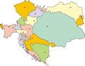 Austria-Hungary map Blanco.svg 783 × 605; 251 KB
-
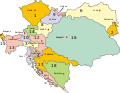 Austria-Hungary map cs.svg 783 × 605; 250 KB
-
 Austria-Hungary map de.svg 783 × 605; 572 KB
-
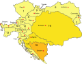
 Austria-Hungary map HE.svg 783 × 605; 274 KB
-
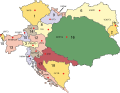 Austria-Hungary map Hebrew.svg 783 × 605; 213 KB
-
 Battaglia di Sacile 1809.png 711 × 554; 280 KB
-
 Battle of Sacile 1809 Map.JPG 711 × 554; 51 KB
-
 Ernst Rudolf Neubauer.JPG 427 × 681; 139 KB
-
 Headdress MET More Hat Photos 0141.jpg 926 × 578; 67 KB
-
 Headdress MET More Hat Photos 016.jpg 3,888 × 2,592; 793 KB
-
 Louise Sturmfeder Buch.jpg 327 × 431; 42 KB
-
 Map - Deutscher Bund 1820.png 600 × 454; 55 KB
-
 Vor dem Ausritt (Landsitz bei Wien).jpg 4,131 × 3,329; 2.51 MB


.jpg)