Category:Automobiles in Kingston upon Hull
Media in category "Automobiles in Kingston upon Hull"
The following 200 files are in this category, out of 267 total.
(previous page) (next page)-
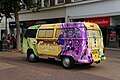
 A Freedom Festival flower car - geograph.org.uk - 3119134.jpg 800 × 600; 160 KB
-
 A Freedom Festival flower car - geograph.org.uk - 3119138.jpg 800 × 600; 118 KB
-
 A Freedom Festival flower car - geograph.org.uk - 3119143.jpg 800 × 600; 135 KB
-
 A tenfoot leading to Westlands Road, Hull (geograph 3309529).jpg 800 × 600; 88 KB
-

-
 A63 Aug23 Mytongate Roadworks New Kerbs.jpg 4,176 × 2,784; 4.15 MB
-
 A63 Aug23 Mytongate Roadworks New Roadway.jpg 4,176 × 2,784; 3.42 MB
-
 A63 Feb24 Highway Maintenance Audi.jpg 4,176 × 2,784; 3.44 MB
-
 A63 Oct23 Ambulance Being Towed Away.jpg 4,176 × 2,784; 3.38 MB
-
 A63 Sep23 Clive Sullivan New Lighting.jpg 4,176 × 2,784; 3.48 MB
-
 A63 Sep23 CSIS Sign.jpg 4,176 × 2,784; 3.49 MB
-
 Aberdovey Close off Cumbian Way, Hull (geograph 6779248).jpg 5,456 × 3,632; 2.94 MB
-
 Albert Dock, Kingston upon Hull - geograph.org.uk - 3395407.jpg 1,752 × 1,150; 530 KB
-
 Bench mark at Springhead Pumping Station (geograph 5908741).jpg 1,600 × 1,064; 925 KB
-
 Biggin Avenue, Hull (geograph 6085828).jpg 4,438 × 3,221; 3.63 MB
-
 Biggin Avenue, Hull (geograph 6085832).jpg 5,184 × 3,888; 4.54 MB
-
 Biggin Avenue, Hull (geograph 6777744).jpg 5,456 × 3,632; 2.87 MB
-
 Blaydes Staith, High Street, Kingston upon Hull - geograph.org.uk - 5266408.jpg 1,799 × 1,199; 913 KB
-
 Blundell's Corner - geograph.org.uk - 1289679.jpg 640 × 427; 300 KB
-
 Brazil Street, Kingston upon Hull - geograph.org.uk - 3462940.jpg 1,749 × 1,143; 615 KB
-
 Bus stop on Wawne Road (geograph 4352681).jpg 640 × 480; 54 KB
-
 Carlsberg Van on King Edward Street, Hull - geograph.org.uk - 4100871.jpg 1,600 × 1,064; 651 KB
-
 Cars turning around due to floods - geograph.org.uk - 3768362.jpg 1,024 × 681; 205 KB
-
 Catterrick Mews off Dent Road, Bricknell Avenue Estate, Hull (geograph 6845289).jpg 5,456 × 3,632; 2.33 MB
-
 Catterrick Mews off Dent Road, Bricknell Avenue Estate, Hull (geograph 6845291).jpg 5,456 × 3,632; 3.26 MB
-
 Chester Road off Wold Road, Hull (geograph 3336739).jpg 800 × 600; 102 KB
-
 Citroen van on Lowgate, Hull - geograph.org.uk - 4101736.jpg 1,600 × 1,064; 707 KB
-
 Close up, Elizabeth II postbox on Priory Road, Hull (geograph 6082284).jpg 2,300 × 4,348; 2.21 MB
-
 Clough Road, Kingston upon Hull AI Camera Van.jpg 3,090 × 2,061; 2.32 MB
-
 Coastguard Personal on Wellington Street, Hull - geograph.org.uk - 5241430.jpg 1,200 × 799; 289 KB
-
 Connexin Live Arena and Multistorey Rear, Aug23.jpg 4,176 × 2,784; 4.24 MB
-
 Connexin Live Arena Rear, Aug23.jpg 4,176 × 2,784; 3.44 MB
-
 Coronation Road South, Hull (geograph 3336886).jpg 800 × 600; 121 KB
-
 Coronation Road South, Hull (geograph 3336965).jpg 800 × 600; 122 KB
-
 Coronation Road South, Hull (geograph 3336968).jpg 800 × 600; 114 KB
-
 Cragdale Close off Howdale Road, Hull (geograph 6828939).jpg 5,456 × 3,632; 2.68 MB
-
 Crosswood Close off Lothian Way, Hull (geograph 6779144).jpg 5,456 × 3,632; 2.78 MB
-
 Demolition work on Myton Street, Hull - geograph.org.uk - 5120348.jpg 1,600 × 1,065; 446 KB
-
 Dock Office Row, Kingston upon Hull - geograph.org.uk - 3395514.jpg 1,713 × 1,150; 651 KB
-
 Dock Street, Hull - geograph.org.uk - 5256368.jpg 1,200 × 799; 320 KB
-
 Elizabeth II postbox on Priory Road, Hull (geograph 6082283).jpg 5,184 × 3,888; 6.32 MB
-

-
 Ernest W Steele ^ Co Ltd - geograph.org.uk - 5120328.jpg 1,600 × 1,065; 501 KB
-
 Falkirk Close off Lothian Way, Hull (geograph 6779156).jpg 5,456 × 3,632; 1.95 MB
-
 Ferensway, Hull, black out and floods - geograph.org.uk - 3769145.jpg 1,024 × 681; 211 KB
-
 Fernhill Road off Ledbury Road, Hull (geograph 3339984).jpg 800 × 566; 100 KB
-
 Fernhill Road off Ledbury Road, Hull (geograph 3340012).jpg 800 × 600; 109 KB
-
 Fernhill Road off Ledbury Road, Hull (geograph 3340016).jpg 800 × 600; 127 KB
-
 Fernhill Road off Ledbury Road, Hull (geograph 3340153).jpg 800 × 600; 182 KB
-
 Fiat Panda at Rosset House, Kingston upon Hull, 1987.jpg 1,127 × 756; 165 KB
-
 Field Street, Kingston upon Hull - geograph.org.uk - 3462989.jpg 1,753 × 1,151; 359 KB
-
 Furness Close off Cumbian Way, Hull (geograph 6779234).jpg 5,456 × 3,632; 1.92 MB
-
 Gandhi Way, Hull - geograph.org.uk - 4149361.jpg 640 × 480; 104 KB
-
 Gandhi Way. Hull - geograph.org.uk - 4149373.jpg 640 × 480; 108 KB
-
 George Street, Kingston upon Hull (geograph 6548226).jpg 2,441 × 1,831; 1.03 MB
-
 George Street, Kingston upon Hull (geograph 6583716).jpg 2,492 × 1,843; 1.31 MB
-
 George VI postbox and telephone box on Wold Road, Hull (geograph 6081750).jpg 5,184 × 3,888; 4.83 MB
-
 George VI postbox on Wold Road, Hull (geograph 6081749).jpg 2,251 × 4,209; 2.55 MB
-
 Gillamoor Close off Howdale Road, Hull (geograph 6829114).jpg 5,456 × 3,632; 2.29 MB
-
 GOLGV Training Services - geograph.org.uk - 4916468.jpg 1,200 × 799; 277 KB
-
 Grammar School Yard, Fish Street, Kingston upon Hull - geograph.org.uk - 3281563.jpg 3,851 × 2,548; 3.82 MB
-
 Greenhow Close off Howdale Road, Hull (geograph 6828934).jpg 5,456 × 3,632; 2.62 MB
-
 Greenhow Close off Howdale Road, Hull (geograph 6828938).jpg 5,456 × 3,632; 2.74 MB
-
 Guildhall Road, Kingston upon Hull - geograph.org.uk - 3286451.jpg 3,859 × 2,561; 3.61 MB
-
 Guildhall Road, Kingston upon Hull - geograph.org.uk - 3286682.jpg 3,783 × 2,443; 4.43 MB
-
 Guildhall Road, Kingston upon Hull - geograph.org.uk - 3395541.jpg 1,722 × 1,102; 305 KB
-
 Ha'Penny Bridge Way, Victoria Dock Village, Hull - geograph.org.uk - 3769042.jpg 1,024 × 681; 151 KB
-
 Hanley Road off Ledbury Road, Hull (geograph 3339991).jpg 800 × 600; 105 KB
-
 Hanley Road off Ledbury Road, Hull (geograph 3339996).jpg 800 × 600; 117 KB
-
 Hanley Road off Ledbury Road, Hull (geograph 3340000).jpg 800 × 600; 101 KB
-
 Hanley Road off Ledbury Road, Hull (geograph 3340005).jpg 800 × 600; 103 KB
-
 Hanley Road off Ledbury Road, Hull (geograph 3340008).jpg 800 × 600; 102 KB
-
 Hanley Road off Ledbury Road, Hull (geograph 3340013).jpg 800 × 600; 135 KB
-
 Hanover Square, Kingston upon Hull - geograph.org.uk - 3286641.jpg 3,851 × 2,551; 3.83 MB
-
 Hanover Square, Kingston upon Hull - geograph.org.uk - 3286695.jpg 3,865 × 2,570; 3.53 MB
-
 Hotham Road South - geograph.org.uk - 407734.jpg 640 × 480; 224 KB
-
 Houses on Barmouth Close, Hull (geograph 6090139).jpg 800 × 551; 79 KB
-
 Houses on Biggin Avenue, Hull (geograph 6085826).jpg 2,883 × 2,140; 876 KB
-
 Houses on Reldene Drive, Hull (geograph 3309457).jpg 800 × 600; 159 KB
-
 Houses on Ridgeway Road, Hull (geograph 3309467).jpg 800 × 600; 121 KB
-
 Houses on Ridgeway Road, Hull (geograph 3309469).jpg 800 × 600; 90 KB
-
 Houses on Springhead Avenue, Hull (geograph 6081696).jpg 5,142 × 3,293; 3.01 MB
-
 Houses on The Ridings, Hull (geograph 3315446).jpg 800 × 600; 127 KB
-
 Houses on Willerby Road, Hull (geograph 6081747).jpg 5,184 × 3,888; 6.8 MB
-
 Houses on Wymersley Road, Hull (geograph 3315799).jpg 800 × 600; 210 KB
-
 Houses on Wymersley Road, Hull (geograph 6081669).jpg 5,184 × 3,888; 5.4 MB
-
 Houses on Wymersley Road, Hull (geograph 6081674).jpg 4,890 × 3,083; 3.53 MB
-
 Houses on Wymersley Road, Hull (geograph 6082275).jpg 4,669 × 3,145; 5.21 MB
-
 Hovingham Close off Howdale Road, Hull (geograph 6828943).jpg 5,456 × 3,632; 2.32 MB
-
 Howdale Road, Hull (geograph 6345700).jpg 4,314 × 2,966; 2.65 MB
-
 Howdale Road, Hull (geograph 6345701).jpg 4,411 × 3,342; 3.4 MB
-
 Howdale Road, Hull (geograph 6828314).jpg 5,456 × 3,632; 2.3 MB
-
 Howdale Road, Hull (geograph 6828318).jpg 5,456 × 3,632; 2.45 MB
-
 Hull -The Minerva - geograph.org.uk - 5348535.jpg 4,608 × 3,456; 6.81 MB
-
 Hull City Centre at gridlock - geograph.org.uk - 3768354.jpg 1,024 × 681; 193 KB
-
 Hull city centre under flood water - geograph.org.uk - 3768411.jpg 1,024 × 681; 197 KB
-
 Hull College Apr23 Chesters Building & Tower Block.jpg 4,176 × 2,784; 3.79 MB
-
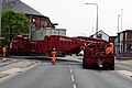
 Hull Dogger Bank Abload Cargo in Holding.jpg 4,176 × 2,784; 3.54 MB
-
 Hull Dogger Bank Abload Departure.jpg 4,176 × 2,784; 3.44 MB
-
 Hull Dogger Bank Abload Escort Vehicles.jpg 4,176 × 2,784; 3.48 MB
-
 Hull Dogger Bank Abload HOTA Tower and Merseyside Police.jpg 4,176 × 2,784; 3.48 MB
-
 Hull Dogger Bank Abload Merseyside Police Vehicles.jpg 4,176 × 2,784; 3.4 MB
-
 Hull Dogger Bank Abload Mini-Roundabout Mounting.jpg 4,176 × 2,784; 3.4 MB
-
 Hull Dogger Bank Abload Navigating Mini-Roundabout.jpg 4,176 × 2,784; 3.44 MB
-
 Hull Dogger Bank Abload Police Presence (cropped).jpg 1,969 × 1,314; 691 KB
-
 Hull Dogger Bank Abload Police Presence.jpg 4,176 × 2,784; 3.47 MB
-
 Hull Dogger Bank Abload South Yorks and Merseyside Police.jpg 4,176 × 2,784; 3.54 MB
-
 Hull Dogger Bank Abload South Yorkshire Police Vehicles.jpg 4,176 × 2,784; 3.51 MB
-
 Hull Dogger Bank Abload SYP Backmarker.jpg 4,176 × 2,784; 3.45 MB
-
 Hull Dogger Bank Abload Trailer and Generator.jpg 4,176 × 2,784; 3.5 MB
-
 Hull Dogger Bank Abload Trailer Unit.jpg 4,176 × 2,784; 3.51 MB
-
 Hull Dogger Bank Abload Transformer Close-Up.jpg 4,176 × 2,784; 4.14 MB
-
 Hull Police Station - geograph.org.uk - 3141518.jpg 1,024 × 798; 153 KB
-
 Humberside Fire & Rescue DH03P4 - YT21 EHF.jpg 2,586 × 1,939; 2.5 MB
-
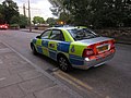
 Humberside Police Area Car EF72 LFU.jpg 2,506 × 1,672; 1.32 MB
-
 Humberside Police Car, Queens Gardens, Hull - geograph.org.uk - 5533694.jpg 1,600 × 1,065; 683 KB
-
 I bet it doesn't get a parking ticket - geograph.org.uk - 3119200.jpg 800 × 600; 117 KB
-
 Ingleby Close off Dunvegan Road, Hull (geograph 6828289).jpg 5,456 × 3,632; 2.8 MB
-
 Jarratt Street, Kingston upon Hull - geograph.org.uk - 3379272.jpg 1,753 × 1,151; 312 KB
-
 Jason Garth off Noddle Hill Way, Hull (geograph 6777777).jpg 5,456 × 3,632; 2.22 MB
-
 John Street, Kingston upon Hull - geograph.org.uk - 3380884.jpg 1,753 × 1,151; 432 KB
-
 KC Lightstream Stadium, Hull - geograph.org.uk - 3825070.jpg 1,200 × 798; 292 KB
-
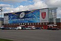 KC Lightstream Stadium, Hull - geograph.org.uk - 3862861.jpg 1,200 × 798; 313 KB
-
 KCOM van ^1 Lord Prescott - geograph.org.uk - 5374027.jpg 1,200 × 812; 346 KB
-
 King Edward Square, Kingston upon Hull - geograph.org.uk - 7052515.jpg 1,280 × 860; 349 KB
-
 King Street, Kingston upon Hull - geograph.org.uk - 3379257.jpg 1,753 × 1,149; 717 KB
-
 Kinloss Garth off Noddle Hill Way, Hull (geograph 6777772).jpg 5,456 × 3,632; 1.8 MB
-
 Ledbury Road off Priory Road, Hull (geograph 3339990).jpg 800 × 600; 111 KB
-
 Leeming Garth off Noddle Hill Way, Hull (geograph 6777766).jpg 5,456 × 3,632; 2.73 MB
-
 Louis Drive off Westlands Road, Hull (geograph 3309537).jpg 800 × 600; 86 KB
-
 Lowgate, Kingston upon Hull - geograph.org.uk - 3358031.jpg 1,130 × 1,487; 727 KB
-
 Lunedale Close off Howdale Road, Hull (geograph 6829110).jpg 5,456 × 3,632; 3.37 MB
-
 Manor Club on Manor Road, Hull (geograph 3305692).jpg 800 × 600; 95 KB
-
 Manor Road at Westlands Road, Hull (geograph 3305708).jpg 800 × 600; 63 KB
-
 Manor Road off Spring Bank West, Hull (geograph 3305711).jpg 800 × 600; 80 KB
-
 Manor Road off Spring Bank West, Hull (geograph 3305713).jpg 800 × 600; 83 KB
-
 Manston Garth off Noddle Hill Way, Hull (geograph 6777759).jpg 5,456 × 3,632; 2.22 MB
-
 Marske Walk off Bishop Alcock Road, Hull (geograph 6845038).jpg 5,456 × 3,632; 1.87 MB
-
 Minerva Public House, Nelson Street, Kingston upon Hull - geograph.org.uk - 3305695.jpg 4,000 × 2,641; 1.24 MB
-
 Moorhouse Road from Wymersley Road, Hull (geograph 3315694).jpg 800 × 600; 83 KB
-
 Neatshead Garth off Noddle Hill Way, Hull (geograph 6777711).jpg 5,456 × 3,632; 1.54 MB
-
 Nelson Road, Hull (geograph 6081704).jpg 5,184 × 3,888; 2.87 MB
-
 Nelson Street, Kingston upon Hull - geograph.org.uk - 3379330.jpg 1,743 × 1,135; 896 KB
-
 New houses on Wymersley Road, Hull (geograph 6081675).jpg 4,852 × 3,074; 2.9 MB
-
 No way out - geograph.org.uk - 3768381.jpg 1,024 × 681; 198 KB
-
 Noodle Hill Way at Biggin Avenue (geograph 6504496).jpg 1,024 × 768; 130 KB
-
 Nowhere to go, Osborne Street, Hull - geograph.org.uk - 3769094.jpg 1,024 × 681; 163 KB
-
 Ocean Boulevard, Victoria Dock Village, Hull - geograph.org.uk - 3769075.jpg 1,024 × 681; 238 KB
-
 Osborne Street, Hull - geograph.org.uk - 5120319.jpg 1,600 × 1,065; 369 KB
-

-
 Poundstretcher on Preston Road, Hull - geograph.org.uk - 3862872.jpg 1,200 × 798; 313 KB
-
 Pride in Hull 2022 Signage.jpg 3,232 × 2,424; 4.32 MB
-
 Prince's Quay, Kingston upon Hull - geograph.org.uk - 3358202.jpg 1,748 × 1,142; 943 KB
-
 Princes Quay Car Park & Ped Entrance, Aug23.jpg 4,176 × 2,784; 4 MB
-
 Priory Road, Hull (geograph 6082285).jpg 5,184 × 3,888; 4.68 MB
-
 Priory Road, Hull (geograph 6082286).jpg 5,184 × 3,888; 5.55 MB
-
 Queen Street, Kingston upon Hull - geograph.org.uk - 3380445.jpg 1,208 × 1,070; 466 KB
-
 Reldene Drive from Willerby Road, Hull (geograph 3309515).jpg 800 × 600; 119 KB
-
 Reldene Drive, Hull (geograph 3309459).jpg 800 × 600; 108 KB
-
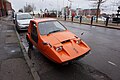 Reliant Bug on Humber Dock Street, Hull - geograph.org.uk - 4782502.jpg 1,200 × 799; 354 KB
-
 Ridgeway Road at Willerby Road, Hull (geograph 3309485).jpg 800 × 600; 89 KB
-
 Ridgeway Road off Willerby Road, Hull (geograph 3309477).jpg 800 × 600; 81 KB
-
 Ridgeway Road off Willerby Road, Hull (geograph 3309479).jpg 800 × 600; 88 KB
-
 Ridgeway Road off Willerby Road, Hull (geograph 3309481).jpg 800 × 600; 79 KB
-
 Ridgeway Road off Willerby Road, Hull (geograph 3309483).jpg 800 × 600; 83 KB
-
 River Grove, Gipsyville - geograph.org.uk - 1190729.jpg 478 × 640; 122 KB
-
 Rosmead Street 'Living With Water' Paving, Kingston upon Hull Jul23 01.jpg 4,176 × 2,784; 3.39 MB
-
 Rosmead Street 'Living With Water' Paving, Kingston upon Hull Jul23 02.jpg 4,176 × 2,784; 3.38 MB
-
 Rosmead Street 'Living With Water' Paving, Kingston upon Hull Jul23 03.jpg 4,176 × 2,784; 3.46 MB
-
 Rosmead Street 'Living With Water' Paving, Kingston upon Hull Jul23 07.jpg 4,176 × 2,784; 3.48 MB
-
 Rosmead Street 'Living With Water' Paving, Kingston upon Hull Jul23 08.jpg 4,176 × 2,784; 3.44 MB
-
 Rosmead Street 'Living With Water' Paving, Kingston upon Hull Jul23 10.jpg 4,176 × 2,784; 4.09 MB
-
 Rosmead Street, Hull - geograph.org.uk - 3741956.jpg 1,024 × 681; 339 KB
-
 Royal Mail Van flies the flag (geograph 5476553).jpg 1,200 × 799; 359 KB
-
 Savile Row Café Bar on Vernon Street, Hull (geograph 5476557).jpg 1,200 × 799; 324 KB
-
 Service station on Robson Way, Hull (geograph 6346466).jpg 800 × 506; 71 KB
-
 Severn Street East Hull - geograph.org.uk - 94326.jpg 640 × 444; 49 KB
-
 Sewell's Van on Vernon Street, Hull (geograph 5476621).jpg 1,200 × 799; 393 KB
-
 Silvester Street, Kingston upon Hull - geograph.org.uk - 3358266.jpg 1,730 × 1,114; 762 KB
-
 Silvester Street, Kingston upon Hull - geograph.org.uk - 3358267.jpg 1,306 × 925; 527 KB
-
 Sittingbourne Close, Hull (geograph 6454136).jpg 1,024 × 768; 1.03 MB
-
 Springhead Avenue, Hull (geograph 3314205).jpg 800 × 600; 100 KB
-
 Springhead Avenue, Hull (geograph 3314214).jpg 800 × 600; 132 KB
-
 Springhead Avenue, Hull (geograph 5908900).jpg 1,600 × 1,064; 520 KB
-
 Springhead Pumping Station (geograph 5908734).jpg 1,600 × 1,064; 644 KB
-
 St Andrew's Dock, Kingston upon Hull - geograph.org.uk - 3257540.jpg 3,803 × 2,475; 3.12 MB
-
 Street Art at Hull's Freedom Festival - geograph.org.uk - 3641369.jpg 800 × 600; 127 KB
-
 Street Art at Hull's Freedom Festival - geograph.org.uk - 3641529.jpg 800 × 600; 164 KB
-
 Street Art at Hull's Freedom Festival - geograph.org.uk - 3646721.jpg 800 × 600; 147 KB
-
 Taking a short cut over the centre pavement, A63 - geograph.org.uk - 3768338.jpg 1,024 × 681; 187 KB
-
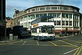
 The Bransholme Centre in 1984 - geograph.org.uk - 2737731.jpg 1,798 × 1,129; 1.97 MB
-

-
 The Coastguard Search ^ Rescue on Plimsoll Way - geograph.org.uk - 3769033.jpg 1,024 × 681; 204 KB
-
 The former Osborne Street multi storey car park, Hull - geograph.org.uk - 5120324.jpg 1,600 × 1,065; 408 KB
-

-
-
 The Highway public house, Hull (geograph 6081677).jpg 4,758 × 3,299; 2.89 MB
-
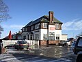
 The Oddbottle public house on Wold Road, Hull (geograph 3305775).jpg 800 × 600; 97 KB
-
 The Waterfront Hotel - geograph.org.uk - 1308367.jpg 640 × 445; 94 KB
-
 There is smoke without fire - geograph.org.uk - 5239361.jpg 1,200 × 799; 324 KB


.jpg)
_(14)_(26831028725).jpg)


.jpg)

.jpg)
.jpg)
.jpg)
.jpg)


.jpg)


.jpg)
.jpg)
.jpg)

.jpg)


.jpg)
.jpg)
.jpg)
.jpg)
.jpg)


.jpg)
_(16)_(26558343240).jpg)

.jpg)

.jpg)
.jpg)
.jpg)
.jpg)


.jpg)


.jpg)
.jpg)
.jpg)
.jpg)
.jpg)


.jpg)
.jpg)


.jpg)
.jpg)
.jpg)
.jpg)
.jpg)
.jpg)


.jpg)
.jpg)
.jpg)
.jpg)
.jpg)
.jpg)
.jpg)
.jpg)
.jpg)
.jpg)
.jpg)
.jpg)
.jpg)
.jpg)
.jpg)
.jpg)
.jpg)


.jpg)


.jpg)

.jpg)


.jpg)
.jpg)
.jpg)
.jpg)

.jpg)
.jpg)
.jpg)
.jpg)
.jpg)
.jpg)
.jpg)

.jpg)
.jpg)
.jpg)

.jpg)

.jpg)


.jpg)
.jpg)

.jpg)
.jpg)

.jpg)
.jpg)
.jpg)
.jpg)
.jpg)


.jpg)
.jpg)
.jpg)

.jpg)


.jpg)
.jpg)
.jpg)
.jpg)
.jpg)


_(39)_(26225760174).jpg)


.jpg)
.jpg)
.jpg)
.jpg)

