Category:Büchel (Thüringen)
municipality in Thuringia, Germany    | |||||
| Upload media | |||||
| Instance of |
| ||||
|---|---|---|---|---|---|
| Location | Landkreis Sömmerda, Thuringia, Germany | ||||
| Population |
| ||||
| Area |
| ||||
| Elevation above sea level |
| ||||
| Different from | |||||
| official website | |||||
 | |||||
Subcategories
This category has the following 3 subcategories, out of 3 total.
Media in category "Büchel (Thüringen)"
The following 23 files are in this category, out of 23 total.
-
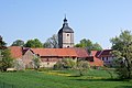
 Blick auf Büchel von Süden.jpg 3,000 × 2,000; 4.47 MB
-
 Büchel 2011-04-22 01.jpg 4,912 × 3,264; 9.15 MB
-
 Büchel 2011-04-22 02.jpg 4,833 × 3,184; 10.92 MB
-
 Büchel 2011-04-22 03.jpg 4,912 × 3,264; 9.95 MB
-
 Büchel 2011-04-22 04.jpg 4,912 × 3,264; 6.96 MB
-
 Büchel 2011-04-22 05.jpg 4,912 × 3,264; 7.32 MB
-
 Büchel 2011-04-22 06.jpg 4,809 × 3,148; 8.59 MB
-
 Büchel 2011-04-22 07.jpg 4,912 × 3,264; 6.8 MB
-
 Büchel 2011-04-22 08.jpg 4,779 × 3,130; 7.57 MB
-
 Büchel 2011-04-22 09.jpg 4,773 × 3,178; 8.9 MB
-
 Büchel 2011-04-22 10.jpg 4,786 × 3,065; 9.11 MB
-
 Büchel 2011-04-22 11.jpg 4,912 × 3,264; 9.07 MB
-
 Büchel 2011-04-22 12.jpg 4,768 × 3,107; 8.35 MB
-
 Büchel 2011-04-22 14.jpg 4,912 × 3,264; 9.3 MB
-
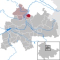 Büchel in SÖM.png 299 × 299; 6 KB
-
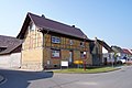
 Büchel, Thuringia 1.jpg 4,608 × 3,456; 3.14 MB
-
 Büchel, Thuringia 2.jpg 3,456 × 4,608; 3.53 MB
-
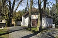 Büchel-Thüringen-Friedhof-CTH.JPG 2,144 × 1,424; 2.48 MB
-
 Büchel-Thüringen-Gutshaus-CTH.JPG 1,408 × 1,592; 1.85 MB
-
 Büchel-Thüringen-Losse-CTH.JPG 2,144 × 1,424; 2.43 MB
-
 Fire station Büchel, Thuringia.jpg 4,608 × 3,456; 3.27 MB
-
 Village pump Büchel, Thuringia.jpg 3,456 × 4,608; 3.47 MB
-
 Wappen Buechel.png 175 × 185; 35 KB


