Category:B184 road (England)

road in England | |||||
| Upload media | |||||
| Instance of |
| ||||
|---|---|---|---|---|---|
| Location | England | ||||
| Transport network |
| ||||
| |||||
Subcategories
This category has only the following subcategory.
B
Media in category "B184 road (England)"
The following 17 files are in this category, out of 17 total.
-

-

-
 Axe & Compasses public house, Aythorpe Roding, Essex, England.jpg 6,021 × 3,387; 17.56 MB
-
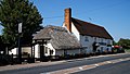
 A thatched and tile-roofed cottage at High Roding, Essex, England 01.jpg 5,472 × 3,648; 6.79 MB
-
 A thatched and tile-roofed cottage at High Roding, Essex, England 02.jpg 5,472 × 3,648; 7 MB
-
 B184 approach to Thaxted - geograph.org.uk - 24914.jpg 640 × 448; 45 KB
-
 B184 from south entering High Roding, Essex, England.jpg 3,993 × 2,535; 6.21 MB
-

-
 Newbiggen Street, Thaxted - geograph.org.uk - 1154074.jpg 640 × 427; 79 KB
-

-
 The B184 near Beauchamp Roding - geograph.org.uk - 723086.jpg 640 × 480; 80 KB
-
 The B184 near Little Cambridge - geograph.org.uk - 288712.jpg 640 × 424; 60 KB
-
 The B184 through High Roding, Essex - geograph.org.uk - 1371517.jpg 640 × 480; 82 KB
-
 Water tower along the B.184 - geograph.org.uk - 368796.jpg 640 × 462; 69 KB
-
 Watling Street, B184, Thaxted - geograph.org.uk - 1363073.jpg 640 × 520; 105 KB
-
 Blamster's Hall, Essex - geograph.org.uk - 192494.jpg 640 × 480; 81 KB
-
 Maysland, near Great Dunmow, Essex - geograph.org.uk - 223301.jpg 640 × 480; 85 KB


