Category:Babuurstermolen
| Object location | | View all coordinates using: OpenStreetMap |
|---|
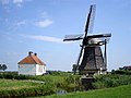
windmill in Tjerkwerd, Netherlands  | |||||
| Upload media | |||||
| Instance of |
| ||||
|---|---|---|---|---|---|
| Location | Tjerkwerd, Friesland, Netherlands | ||||
| Street address |
| ||||
| Has use |
| ||||
| Heritage designation |
| ||||
| Source of energy | |||||
 | |||||
|
This is a category about rijksmonument number 39431
|
| Address |
|
Media in category "Babuurstermolen"
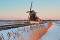
The following 19 files are in this category, out of 19 total.
-
 20190821 zicht op de Babuurstermolen vanuit het noordwesten.jpg 5,184 × 3,456; 3.65 MB
-

-

-

-
 Babuurstermolen 18.JPG 1,024 × 768; 100 KB
-
 Beabuorstermûne, Tsjerkwerd.jpg 1,804 × 1,203; 893 KB
-

-

-
 Gevelsteen van achtkante grondzeiler - AMR Molenfoto - 20539295 - RCE.jpg 1,200 × 900; 273 KB
-
 Interieur van achtkante grondzeiler - AMR Molenfoto - 20539303 - RCE.jpg 1,200 × 900; 189 KB
-

-
 Tsjerkwert, Beabuorstermûne.jpg 3,872 × 2,592; 4.13 MB
-
 Vergezicht met achtkante grondzeiler - AMR Molenfoto - 20539292 - RCE.jpg 1,200 × 900; 131 KB
-
 Watermolen van waterschap "Exmorra" - Tjerkwerd - 20209697 - RCE.jpg 788 × 1,200; 178 KB
-
 Watermolen van waterschap "Exmorra" - Tjerkwerd - 20209698 - RCE.jpg 788 × 1,200; 182 KB
-
 Woonhuis bij achtkante grondzeiler - AMR Molenfoto - 20539298 - RCE.jpg 1,200 × 900; 168 KB
-
 Woonhuis bij achtkante grondzeiler - AMR Molenfoto - 20539299 - RCE.jpg 1,200 × 900; 183 KB
-
 Woonhuis bij achtkante grondzeiler - AMR Molenfoto - 20539300 - RCE.jpg 1,200 × 900; 181 KB
-
 Woonhuis bij achtkante grondzeiler - AMR Molenfoto - 20539301 - RCE.jpg 1,200 × 900; 137 KB


