Category:Bad Gams
former municipality in Austria   | |||||
| Upload media | |||||
| Instance of |
| ||||
|---|---|---|---|---|---|
| Location | |||||
| Population |
| ||||
| Area |
| ||||
| Elevation above sea level |
| ||||
 | |||||
Subcategories
This category has the following 14 subcategories, out of 14 total.
F
G
H
J
M
- Märchensee (Bad Gams) (4 F)
P
- Pfarrhof Bad Gams (6 F)
R
- Rosenkogel (Koralpe) (21 F)
S
- Schrattelofen, Bad Gams (14 F)
W
- Wohnhaus Furth 11, Bad Gams (10 F)
- Wohnhaus Furth 14, Bad Gams (19 F)
Media in category "Bad Gams"
The following 44 files are in this category, out of 44 total.
-
 20240330-bücherzelle-volksschule-bad-gams.jpg 3,773 × 3,239; 2.58 MB
-
 AUT Bad Gams COA.jpg 414 × 497; 132 KB
-
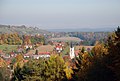
 Bad Gams aus dem Süden.jpg 2,896 × 1,944; 1.44 MB
-
 Bad Gams aus dem Süden2.jpg 2,896 × 1,944; 4.65 MB
-
 Bad Gams Denkmal Eduard Wagnes cropped.jpg 416 × 515; 247 KB
-
 Bad Gams Denkmal Eduard Wagnes.jpg 1,944 × 2,896; 6.3 MB
-
 Bad Gams im Bezirk DL.png 645 × 645; 29 KB
-
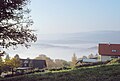
 Bad Gams Ortsteil Furth.jpg 2,896 × 1,944; 1.46 MB
-
 Bad Gams Pfarrkirche von Joslannerkapelle.jpg 2,896 × 1,944; 1.51 MB
-
 Bad Gams Pfarrkirche von Süden.jpg 2,896 × 1,944; 3.76 MB
-
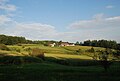
 Bad Gams Sallegg mittleres Wildbachtal.jpg 2,896 × 1,944; 3.86 MB
-
 Bad Gams von Joslannerkapelle.jpg 1,944 × 2,896; 1.6 MB
-
 Bad Gams westl Ort von Joslannerlkapelle.jpg 1,944 × 2,896; 3.91 MB
-
 Bad Gams, westlicher Ort von der Joslannerlkapelle.jpg 2,896 × 1,944; 1.67 MB
-
 Beichtzettel Gams 1926.jpg 4,008 × 1,900; 4.11 MB
-
De-Bad Gams.ogg 2.1 s; 20 KB
-
 Ehem Volksschule Sallegg.jpg 2,896 × 1,944; 1.94 MB
-
 Fahrplan Sommer 1939 Graz - Stainz - Deutschlandsberg Bahn-Bus.jpg 3,294 × 4,704; 10.49 MB
-
 Fahrpläne Deutschlandsberg Stainz Köflach 1975-76.jpg 10,622 × 8,295; 12.73 MB
-
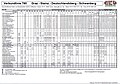
 Fahrpläne Graz Stainz Deutschlandsberg Arnfels 1969-70.jpg 5,324 × 4,126; 11.75 MB
-
 Fahrpläne Köflach Lankowitz Wies Stainz Schwanberg 1961-62.jpg 5,286 × 4,180; 16.75 MB
-
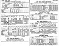
 Fahrpläne Stainz Deutschlandsberg Schwanberg Köflach Sommer 1956.jpg 5,352 × 4,315; 6.62 MB
-
 Fahrpläne Stainz Deutschlandsberg Schwanberg Preding 1956-57.jpg 5,520 × 4,284; 6.47 MB
-
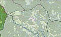 Gebiet der Pfarre St Oswald in Freiland 2018.jpg 958 × 579; 442 KB
-
 GKB Bus Streckenliste 2019.jpg 419 × 868; 85 KB
-
 GKB Deutschlandsberg Stainz Graz 2019.jpg 1,271 × 901; 332 KB
-
 GKB Graz Stainz Deutschlandsberg 2019.jpg 1,279 × 900; 340 KB
-
 Grenzen Gersdorf Tanzelsdorf Schamberg Rassach.jpg 1,052 × 669; 428 KB
-
 Kothvogl Bad Gams.JPG 2,896 × 1,944; 1.75 MB
-
 Kriegerdenkmal War Memorial Bad Gams.jpg 5,511 × 3,674; 5.72 MB
-
 Map at bad-gams.png 400 × 240; 3 KB
-
 Personalstand 1817.jpg 3,295 × 2,664; 5.61 MB
-
 Rechnung Pieber Deutschlandsberg Dicopur+Sense 1963-05-17 Rückseite.jpg 5,756 × 6,960; 26.69 MB
-
 Rechnung Pieber Deutschlandsberg Dicopur+Sense 1963-05-17.jpg 5,733 × 6,960; 20.1 MB
-
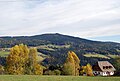
 Rosenkogel mit Sallegg.jpg 2,896 × 1,944; 502 KB
-
 Sallegg mit Rosenkogel.jpg 2,896 × 1,944; 636 KB
-
 Sallegg von Freiland aus.jpg 2,896 × 1,944; 691 KB
-
 Schloß Deutschlandsberg Eingangstor 1935 Textseite.jpg 6,516 × 4,212; 13.53 MB
-
 StmkLGBl 1850 Gemeindegliederung Stainz Gams.jpg 22,940 × 17,495; 12.28 MB
-
 Vochera am Abhang der Koralpe.jpg 2,896 × 1,944; 3.75 MB
-
 Vochera Bad Gams.JPG 2,896 × 1,944; 1.78 MB
-
 Vochera Bad Gams2.JPG 2,896 × 1,944; 1.48 MB
-
 Wandbild Volksschule Sallegg.jpg 2,896 × 1,944; 1.67 MB
-
 Wildbachtal breit.jpg 2,896 × 1,944; 4.51 MB


