Category:Bakkerstraat 21, Arnhem
| Object location | | View all coordinates using: OpenStreetMap |
|---|
building in Arnhem, Netherlands  | |||||
| Upload media | |||||
| Instance of | |||||
|---|---|---|---|---|---|
| Location | Arnhem, Gelderland, Netherlands | ||||
| Street address |
| ||||
| Located on street | |||||
| Heritage designation |
| ||||
 | |||||
|
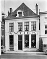
This is a category about rijksmonument number 8299
|
| Address |
|
Media in category "Bakkerstraat 21, Arnhem"
The following 4 files are in this category, out of 4 total.
-
 Arnhem - Bakkerstraat 21.jpg 1,944 × 2,592; 1.34 MB
-
 Tot eind, voorgevels - Arnhem - 20025226 - RCE.jpg 964 × 1,200; 212 KB
-
 Voorgevel - Arnhem - 20025227 - RCE.jpg 953 × 1,200; 241 KB
-
 Voorgevel - Arnhem - 20025228 - RCE.jpg 954 × 1,200; 246 KB


