Category:Balat (Istanbul)
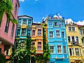
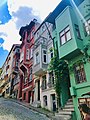
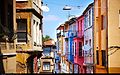
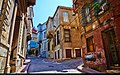
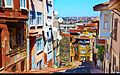
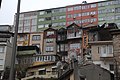
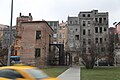
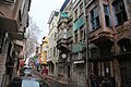
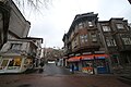
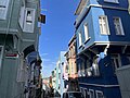
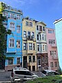
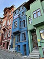
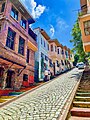
neighborhood in Fatih, Istanbul, Turkey  Balat – colourful houses in the historic center | |||||
| Upload media | |||||
| Instance of |
| ||||
|---|---|---|---|---|---|
| Location |
| ||||
| Population |
| ||||
 | |||||
Subcategories
This category has the following 16 subcategories, out of 16 total.
A
- Akçin Street, Fatih (7 F)
- Ayvansaray Avenue (5 F)
B
- Balat Or-Ahayim Hospital (8 F)
C
- Cistern of Aspar (1 F)
E
- Estipol Synagogue (1 F)
F
- Fethiye Street, Fatih (1 F)
H
- Halil Ağa Fountain (1 F)
P
- Phanar Greek Orthodox college (60 F)
S
- Sancaktar Yokuşu (3 F)
T
- Tevkîî Cafer Çelebi Mosque (1 F)
V
- Vodina Street (2 F)
Y
- Yanbol Synagogue (2 F)
- Yıldırım Street, Fatih (1 F)
Ş
- Şair Nedim Park (1 F)
Media in category "Balat (Istanbul)"
The following 120 files are in this category, out of 120 total.
-
 46 Vodina St, Istanbul.jpg 3,024 × 3,817; 4.27 MB
-
 68 Camcı Çeşmesi St, Istanbul.jpg 3,024 × 4,001; 8.13 MB
-
 A building in Balat, Istanbul.jpg 3,024 × 4,032; 2.31 MB
-
 A building in Balat.jpg 3,024 × 4,032; 1.62 MB
-
 A mosque and wooden house in the Balat neighbourhood of Istanbul.jpg 5,472 × 3,648; 6.37 MB
-
 A wooden house in the Balat neighbourhood of Istanbul 1.jpg 5,472 × 3,648; 7.84 MB
-
 A wooden house in the Balat neighbourhood of Istanbul 2.jpg 5,472 × 3,648; 7.01 MB
-
 A wooden Yali being repaired by the Bosphorous, Balat neighbourhood, Istanbul.jpg 5,472 × 3,648; 6.89 MB
-
 An apartment in Balat.jpg 3,024 × 4,032; 2.8 MB
-
 An old stone house in the Balat neighbourhood of Istanbul.jpg 5,472 × 3,648; 6.29 MB
-
 Balat (Fatih, Istanbul) 01.jpg 4,160 × 3,120; 1.55 MB
-
 Balat (Fatih, Istanbul) 02.jpg 4,160 × 3,120; 2.1 MB
-
 Balat (Fatih, Istanbul) 03.jpg 2,631 × 1,911; 2.66 MB
-
 Balat (Fatih, Istanbul) 04.jpg 3,072 × 4,160; 5.98 MB
-
 Balat (Fatih, Istanbul) 05.jpg 4,160 × 3,120; 6.06 MB
-
 Balat (Fatih, Istanbul) 06.jpg 3,592 × 3,120; 5.29 MB
-
 Balat (Fatih, Istanbul) 07.jpg 2,724 × 3,836; 4.48 MB
-
 Balat (Fatih, Istanbul) 08.jpg 4,160 × 2,848; 5.73 MB
-
 Balat (Fatih, Istanbul) 09.jpg 4,160 × 3,120; 2.05 MB
-
 Balat (Fatih, Istanbul) 10.jpg 4,160 × 2,304; 4.4 MB
-
 Balat (Fatih, Istanbul) 11.jpg 3,838 × 2,751; 5.59 MB
-
 Balat (Fatih, Istanbul) 12.jpg 3,900 × 2,437; 4.66 MB
-
 Balat (Fatih, Istanbul) 13.jpg 4,160 × 2,232; 4.04 MB
-
 Balat houses.jpg 4,032 × 3,024; 2.8 MB
-
 Balat Mistik Dükkan.jpg 1,536 × 2,048; 640 KB
-
 Balat Nostaljik Bakkal.jpg 1,536 × 2,048; 682 KB
-
 Balat Renkleri.jpg 1,536 × 2,048; 689 KB
-
 Balat Sokakları.jpg 1,536 × 2,048; 661 KB
-
 Balat Street (1).jpg 6,016 × 4,000; 17.36 MB
-
 Balat Şemsiyeleri.jpg 1,756 × 2,048; 764 KB
-
 Balat.jpg 768 × 1,024; 479 KB
-
 Balatın Renkli Evleri.jpg 1,536 × 2,048; 521 KB
-
 Casa di legno.jpg 6,110 × 4,089; 17.13 MB
-
 Cennet Mahallesi dizisi.jpg 3,236 × 4,506; 10.14 MB
-
 Church of St Mary of the Mongols, Balat, 34087 Fatih, İstanbul, Turkey.jpg 3,648 × 5,472; 6.14 MB
-
 Colorful apartment buildings, Istanbul, Turkey.jpg 4,032 × 3,024; 2.75 MB
-
 Colorful Balat houses.jpg 3,024 × 4,032; 2.87 MB
-
 Colourful houses in Fethiye-Balat district, Istanbul 2.jpg 5,472 × 3,648; 6.34 MB
-
 Colourful houses in Fethiye-Balat district, Istanbul 3.jpg 5,472 × 3,648; 7.17 MB
-
 Colourful houses in Fethiye-Balat district, Istanbul 4.jpg 5,472 × 3,648; 5.67 MB
-
 Colourful houses in Fethiye-Balat district, Istanbul 5.jpg 5,472 × 3,648; 5.53 MB
-
 Colourful houses in Fethiye-Balat district, Istanbul.jpg 5,472 × 3,648; 7.19 MB
-
 DM01 - Balat.jpg 2,272 × 1,704; 2.19 MB
-
 Fener Rum Lisesi yan.jpg 1,080 × 1,329; 173 KB
-
 Fener street.jpg 4,000 × 6,016; 16.87 MB
-
 Houses in Balat.jpg 3,024 × 4,032; 2.59 MB
-
 Istanbul (10777821154).jpg 2,448 × 3,264; 2.87 MB
-
 Istanbul (8082262927).jpg 3,840 × 2,391; 4.69 MB
-
 Istanbul (8273665835).jpg 3,840 × 2,392; 4.68 MB
-
 Istanbul (8273666591).jpg 3,840 × 2,391; 4.47 MB
-
 Istanbul (8274731030).jpg 3,840 × 2,391; 4.63 MB
-
 Istanbul 120 (40761753922).jpg 1,536 × 2,048; 314 KB
-
 Istanbul Balat 2022.jpg 4,032 × 3,024; 9.87 MB
-
 Istanbul photos by J.Lubbock 2014 343.jpg 5,472 × 3,648; 8.25 MB
-
 Istanbul photos by J.Lubbock 2014 344.jpg 5,472 × 3,648; 4.96 MB
-
 Istanbul photos by J.Lubbock 2014 345.jpg 3,648 × 5,472; 5.15 MB
-
 Istanbul photos by J.Lubbock 2014 346.jpg 5,472 × 3,648; 8.11 MB
-
 Istanbul photos by J.Lubbock 2014 347.jpg 5,472 × 3,648; 7.05 MB
-
 Istanbul photos by J.Lubbock 2014 355.jpg 5,472 × 3,648; 7.24 MB
-
 Istanbul photos by J.Lubbock 2014 356.jpg 3,648 × 5,472; 4.83 MB
-
 Istanbul photos by J.Lubbock 2014 362.jpg 5,472 × 3,648; 6.22 MB
-
 Istanbul photos by J.Lubbock 2014 364.jpg 5,472 × 3,648; 5.9 MB
-
 Istanbul photos by J.Lubbock 2014 365.jpg 5,472 × 3,648; 6.12 MB
-
 Istanbul photos by J.Lubbock 2014 366.jpg 5,472 × 3,648; 5.33 MB
-
 Istanbul photos by J.Lubbock 2014 367.jpg 5,472 × 3,648; 5.56 MB
-
 Istanbul photos by J.Lubbock 2014 368.jpg 5,472 × 3,648; 8.26 MB
-
 Istanbul photos by J.Lubbock 2014 369.jpg 5,472 × 3,648; 7.89 MB
-
 Istanbul photos by J.Lubbock 2014 370.jpg 5,472 × 3,648; 6.77 MB
-
 Istanbul photos by J.Lubbock 2014 371.jpg 5,472 × 3,648; 7.52 MB
-
 Istanbul photos by J.Lubbock 2014 372.jpg 5,472 × 3,648; 5.74 MB
-
 Istanbul photos by J.Lubbock 2014 373.jpg 5,472 × 3,648; 6.27 MB
-
 Istanbul photos by J.Lubbock 2015 374.jpg 5,472 × 3,648; 5.96 MB
-
 Istanbul photos by J.Lubbock 2015 375.jpg 5,472 × 3,648; 5.91 MB
-
 Istanbul photos by J.Lubbock 2015 385.jpg 5,472 × 3,648; 6.58 MB
-
 Istanbul photos by J.Lubbock 2015 386.jpg 5,472 × 3,648; 5.87 MB
-
 Istanbul photos by J.Lubbock 2015 387.jpg 3,648 × 5,472; 6.1 MB
-
 Istanbul photos by J.Lubbock 2015 390.jpg 3,648 × 5,472; 6.38 MB
-
 Istanbul photos by J.Lubbock 2015 391.jpg 5,472 × 3,648; 4.94 MB
-
 Istanbul photos by J.Lubbock 2015 392.jpg 5,472 × 3,648; 6.16 MB
-
 Istanbul photos by J.Lubbock 2015 393.jpg 5,472 × 3,648; 5.89 MB
-
 Istanbul photos by J.Lubbock 2015 394.jpg 5,472 × 3,648; 6.36 MB
-
 Istanbul photos by J.Lubbock 2015 395.jpg 5,472 × 3,648; 7.58 MB
-
 Istanbul photos by J.Lubbock 2015 396.jpg 5,472 × 3,648; 7.41 MB
-
 Istanbul photos by J.Lubbock 2015 397.jpg 5,472 × 3,648; 5.67 MB
-
 Istanbul photos by J.Lubbock 2015 398.jpg 5,472 × 3,648; 7.44 MB
-
 Istanbul, Turkey (November 2023) - 711.jpg 4,032 × 3,024; 3.74 MB
-
 Istanbul, Turkey (November 2023) - 723.jpg 4,032 × 3,024; 3.98 MB
-
 Istanbul, Turkey (November 2023) - 724.jpg 3,024 × 4,032; 3.31 MB
-
 Istanbul, Turkey (November 2023) - 725.jpg 4,032 × 3,024; 3.29 MB
-
 Istanbul, Turkey (November 2023) - 726.jpg 4,032 × 3,024; 4 MB
-
 Istanbul, Turkey (November 2023) - 727.jpg 3,024 × 4,032; 3.62 MB
-
 Istanbul, Turkey (November 2023) - 728.jpg 3,024 × 4,032; 5.01 MB
-
 Istanbul, Turkey (November 2023) - 729.jpg 4,032 × 3,024; 3.74 MB
-
 Istanbul, Turkey (November 2023) - 730.jpg 3,024 × 4,032; 3.95 MB
-
 Istanbul, Turkey (November 2023) - 733.jpg 4,032 × 3,024; 3.04 MB
-
 Istanbul, Turkey, old town. (33448470451).jpg 4,928 × 3,264; 4.85 MB
-
 Istanbul, İstanbul, Turkey - panoramio (40).jpg 5,040 × 3,360; 6.25 MB
-
 Mesnevihane Street, Fatih, Istanbul (November 2023).jpg 3,024 × 4,032; 3.89 MB
-
 Mürselpaşa Caddesi Fenerli Oda 5 (b).jpg 6,016 × 4,000; 17.32 MB
-
 Mürselpaşa Caddesi Fenerli Oda 5.jpg 6,016 × 4,000; 16.62 MB
-
 Old stone building near the Greek Orthodox Ecumenical Patriarchate, Balat, Istanbul.jpg 5,472 × 3,648; 6.99 MB
-
 PierreLottiHill.jpg 3,024 × 4,032; 6.57 MB
-
 Selvi Boylum Al Yazmalım poster.jpg 3,024 × 4,032; 2.32 MB
-
 Sleepy cat in Balat.jpg 2,819 × 2,114; 1.83 MB
-
 Streundende Katze Istanbul Balat.jpg 2,400 × 1,600; 1.74 MB
-
 Tahta Minare mosque.jpg 3,024 × 3,945; 2.75 MB
-
 The Colorful Balat.jpg 3,024 × 4,032; 4.04 MB
-
 Traditional Istanbul Houses in Balat.jpg 1,536 × 2,040; 520 KB
-
 View of Balat.jpg 3,024 × 2,268; 4.31 MB
-
 Vodina St, Istanbul.jpg 3,024 × 3,722; 4.87 MB
-
 Wooden houses in Balat, Fatih.jpg 3,024 × 4,032; 2.7 MB
-
 Wooden houses near the Greek Orthodox Ecumenical Patriarchate, Balat, Istanbul.jpg 5,472 × 3,648; 5.89 MB
-
 Çimen St, Istanbul.jpg 3,024 × 3,563; 2.98 MB
-
 İstanbul - Balat - Mart 2013 - banner.jpg 2,471 × 353; 185 KB
-
 İstanbul - Balat - Mart 2013 - R1.jpg 2,416 × 1,455; 601 KB
-
 İstanbul - Balat - Mart 2013 - R2.jpg 2,048 × 1,536; 569 KB
-
 İstanbul - Balat - Mart 2013.jpg 2,471 × 1,610; 709 KB
-
 İstanbul - Fener - Mart 2013.jpg 2,431 × 1,286; 683 KB
-
 İstanbul balat.jpg 2,048 × 1,536; 503 KB
-
 İstanbul Balat.jpg 1,200 × 1,500; 667 KB


_01.jpg)
_02.jpg)
_03.jpg)
_04.jpg)
_05.jpg)
_06.jpg)
_07.jpg)
_08.jpg)
_09.jpg)
_10.jpg)
_11.jpg)
_12.jpg)
_13.jpg)


.jpg)


.jpg)
.jpg)
.jpg)
.jpg)
.jpg)
.jpg)


_-_711.jpg)
_-_723.jpg)
_-_724.jpg)
_-_725.jpg)
_-_726.jpg)
_-_727.jpg)
_-_728.jpg)
_-_729.jpg)
_-_730.jpg)
_-_733.jpg)
.jpg)
.jpg)
.jpg)
.jpg)


