Category:Barmby Moor
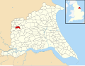
English: Barmby Moor is a village and civil parish in the East Riding of Yorkshire, England. It is situated approximately 1.5 miles (2.4 km) west of Pocklington. It lies north of the A1079 road where it is met by the B1246 road that passes through the village.
a village located in East Riding of Yorkshire, United Kingdom  | |||||
| Upload media | |||||
| Instance of | |||||
|---|---|---|---|---|---|
| Location | East Riding of Yorkshire, Yorkshire and the Humber, England | ||||
 | |||||
Subcategories
This category has only the following subcategory.
S
Media in category "Barmby Moor"
The following 111 files are in this category, out of 111 total.
-
 A fine pheasant - geograph.org.uk - 793645.jpg 640 × 427; 98 KB
-

-
 A minor road near the Steer Inn - geograph.org.uk - 3130951.jpg 800 × 600; 300 KB
-
 A shower approaching the gliding club - geograph.org.uk - 6163132.jpg 1,024 × 576; 50 KB
-
 A walk from Wilberfoss ^49 - geograph.org.uk - 2003607.jpg 800 × 600; 263 KB
-
 A walk from Wilberfoss ^50 - geograph.org.uk - 2003610.jpg 800 × 600; 233 KB
-
 A walk from Wilberfoss ^51 - geograph.org.uk - 2003618.jpg 800 × 600; 339 KB
-
 A walk from Wilberfoss ^52 - geograph.org.uk - 2003622.jpg 800 × 600; 299 KB
-
 A walk from Wilberfoss ^53 - geograph.org.uk - 2003625.jpg 800 × 600; 240 KB
-
 A walk from Wilberfoss ^54 - geograph.org.uk - 2003633.jpg 800 × 600; 287 KB
-
 A walk from Wilberfoss ^55 - geograph.org.uk - 2003637.jpg 800 × 600; 381 KB
-
 A walk from Wilberfoss ^56 - geograph.org.uk - 2003640.jpg 800 × 600; 272 KB
-
 A walk from Wilberfoss ^57 - geograph.org.uk - 2003644.jpg 800 × 600; 249 KB
-
 A1079 junction with Sutton Road - geograph.org.uk - 5356667.jpg 640 × 427; 249 KB
-
 Along Sutton Lane - geograph.org.uk - 5356657.jpg 640 × 427; 218 KB
-
 Approaching crossroads on A1079 west of Barmby Moor - geograph.org.uk - 3166295.jpg 2,560 × 1,920; 1.76 MB
-
 Avenue of Trees - geograph.org.uk - 386528.jpg 640 × 480; 98 KB
-
 Barmby Moor 1927 (archive ref PO-1-7-2) (30433370436).jpg 658 × 413; 66 KB
-
 Barmby Moor Post Office - geograph.org.uk - 361021.jpg 640 × 480; 80 KB
-
 Barmby Moor UK parish locator map.svg 1,425 × 1,107; 1.68 MB
-
 Barmby Moor Village - geograph.org.uk - 107838.jpg 640 × 480; 120 KB
-
 Barmby Moor Village.jpg 640 × 519; 114 KB
-
 Barmbyfield House - geograph.org.uk - 1048873.jpg 640 × 474; 79 KB
-
 Barony of Moor.jpg 5,242 × 3,660; 1.75 MB
-
 Beck near Beck Farm - geograph.org.uk - 1846047.jpg 640 × 480; 122 KB
-
 Beck Side from Spout Hall - geograph.org.uk - 1053408.jpg 640 × 405; 394 KB
-
 Bramble Dean - geograph.org.uk - 5356673.jpg 640 × 427; 183 KB
-
 Calley Heath Nature Reserve - geograph.org.uk - 3133485.jpg 800 × 600; 251 KB
-
 Canal Lane, Pocklington - geograph.org.uk - 1571510.jpg 640 × 426; 190 KB
-
 Canal Lane, Pocklington - geograph.org.uk - 4463878.jpg 2,448 × 1,624; 1.58 MB
-
 Carr Lane towards the A1079 - geograph.org.uk - 3130957.jpg 800 × 600; 289 KB
-
 Chicken farm - geograph.org.uk - 5356647.jpg 640 × 427; 200 KB
-
 Cottage on Hull Road, near Wilberfoss - geograph.org.uk - 5746590.jpg 640 × 604; 610 KB
-
 Doomsday Book Entry 2 Barmby (Moor).png 1,665 × 2,245; 278 KB
-
 Doomsday Book, Entry 1 Barmby (Moor).png 1,665 × 2,245; 335 KB
-
 Drive to Castle Farm - geograph.org.uk - 5356653.jpg 640 × 427; 242 KB
-
 Entering Barmby Moor from the east - geograph.org.uk - 1051617.jpg 640 × 427; 413 KB
-
 Entering Barmby Moor, East Yorkshire - geograph.org.uk - 2518045.jpg 800 × 600; 227 KB
-
 Entering Pocklington from the west - geograph.org.uk - 1053400.jpg 640 × 382; 281 KB
-
 Farm track near Barmby Moor - geograph.org.uk - 1846012.jpg 640 × 480; 97 KB
-
 Farmland near Barmby Moor - geograph.org.uk - 1846017.jpg 640 × 480; 72 KB
-
 Farmland off Sutton Lane - geograph.org.uk - 5356661.jpg 640 × 427; 206 KB
-
 Field drain beside Kedspring Lane - geograph.org.uk - 1845992.jpg 640 × 480; 115 KB
-
 Field of rape near Pocklington airfield - geograph.org.uk - 1415525.jpg 640 × 480; 149 KB
-
 Garage on the A1079 - geograph.org.uk - 5356678.jpg 640 × 427; 213 KB
-
 Hodsow Lane, Pocklington - geograph.org.uk - 4463830.jpg 2,448 × 1,624; 1.69 MB
-
 Hull Road from Hull Road - geograph.org.uk - 5356696.jpg 640 × 427; 225 KB
-
 Hull Road junction - geograph.org.uk - 5356699.jpg 640 × 427; 215 KB
-
 Junction Main Street and St Helen's Square Barmby Moor - geograph.org.uk - 724711.jpg 1,744 × 1,308; 1.16 MB
-
 Lane to Castle Farm - geograph.org.uk - 5717940.jpg 1,600 × 1,200; 684 KB
-
 Lane to Tithe Farm - geograph.org.uk - 5717938.jpg 1,600 × 1,200; 401 KB
-
 Lane to Westfield Farm - geograph.org.uk - 5717943.jpg 1,600 × 1,200; 786 KB
-
 Lane towards Frog Hall - geograph.org.uk - 5717942.jpg 1,600 × 1,200; 933 KB
-
 Large buildings near the A1079 - geograph.org.uk - 5274475.jpg 4,608 × 3,456; 2.76 MB
-
 Long straight road - geograph.org.uk - 107831.jpg 640 × 480; 98 KB
-
 Looking across the Broats - geograph.org.uk - 2518073.jpg 800 × 600; 256 KB
-
 Main Street Barmby Moor.jpg 640 × 427; 294 KB
-
 Main Street, Barmby Moor - geograph.org.uk - 1055568.jpg 640 × 427; 275 KB
-
 Main Street, Barmby Moor - geograph.org.uk - 1846000.jpg 640 × 480; 66 KB
-
 Main Street, Barmby Moor - geograph.org.uk - 2518053.jpg 800 × 600; 209 KB
-
 Modern housing, Barmby Moor - geograph.org.uk - 1845995.jpg 640 × 510; 66 KB
-
 New housing in Pocklington - geograph.org.uk - 1051647.jpg 640 × 427; 335 KB
-
 New Shell garage for the A1079 near Pocklington - geograph.org.uk - 4131358.jpg 1,600 × 1,027; 387 KB
-
 Old Caravan - geograph.org.uk - 383023.jpg 640 × 467; 116 KB
-
 Paddock, Barmby Moor Manor House - geograph.org.uk - 1092570.jpg 640 × 454; 140 KB
-
 Petrol station and services on A1079 York Road - geograph.org.uk - 5558654.jpg 4,153 × 3,023; 3.44 MB
-
 Pocklington Airfield - geograph.org.uk - 107841.jpg 640 × 480; 89 KB
-
 Pocklington Airfield - geograph.org.uk - 5412717.jpg 640 × 500; 330 KB
-
 Pocklington Airfield, Pocklington - geograph.org.uk - 4463717.jpg 2,448 × 1,624; 1.5 MB
-

-
 Pocklington entrance sign on Hodsow Lane - geograph.org.uk - 4463848.jpg 2,448 × 1,624; 1.58 MB
-
 Pocklington Industrial Estate - geograph.org.uk - 1051668.jpg 640 × 344; 264 KB
-
 Pocklington Industrial Estate - geograph.org.uk - 132976.jpg 640 × 425; 60 KB
-
 Pocklington Industrial Estate - geograph.org.uk - 9238.jpg 640 × 480; 73 KB
-
 Pocklington Industrial Estate, Pocklington - geograph.org.uk - 4463706.jpg 2,448 × 1,624; 1.65 MB
-
 Power Lines - geograph.org.uk - 107834.jpg 640 × 480; 79 KB
-
 Road exiting Allerthorpe Common - geograph.org.uk - 5356646.jpg 640 × 427; 218 KB
-

-
 Shell Garage on the A1079 near Pocklington - geograph.org.uk - 4463690.jpg 2,448 × 1,624; 1.1 MB
-
 Shell Garage on the A1079 near Pocklington - geograph.org.uk - 4463697.jpg 2,448 × 1,624; 974 KB
-
 Slow marking - geograph.org.uk - 5356655.jpg 640 × 427; 209 KB
-
 St. Catherine's Church, Barmby Moor - geograph.org.uk - 1846005.jpg 640 × 480; 72 KB
-
 Sutton Lane - geograph.org.uk - 5356648.jpg 640 × 427; 226 KB
-
 Sutton Lane - geograph.org.uk - 5356669.jpg 640 × 427; 198 KB
-
 Sutton Lane in Barmby Moor - geograph.org.uk - 5356665.jpg 640 × 427; 199 KB
-
 Sutton Lane towards Sutton upon Derwent - geograph.org.uk - 1846027.jpg 640 × 478; 103 KB
-
 Thai Season - geograph.org.uk - 5356680.jpg 640 × 427; 174 KB
-
 Thai Season - geograph.org.uk - 5717620.jpg 1,600 × 1,200; 443 KB
-
 The Beck, Barmby Moor - geograph.org.uk - 1092563.jpg 640 × 451; 117 KB
-
 The Beck, Barmby Moor - geograph.org.uk - 1092567.jpg 640 × 452; 136 KB
-
 The Boot and Slipper, Barmby Moor - geograph.org.uk - 1051491.jpg 640 × 460; 308 KB
-
 The Boot and Slipper, Barmby Moor - geograph.org.uk - 1845998.jpg 640 × 489; 58 KB
-
 The Calley Heath nature reserve - geograph.org.uk - 3130966.jpg 800 × 600; 191 KB
-
 The Manor House, Barmby Moor - geograph.org.uk - 1092560.jpg 640 × 461; 128 KB
-
 The road out of Barmby Moor - geograph.org.uk - 107836.jpg 640 × 480; 130 KB
-
 The road to Barmby Moor - geograph.org.uk - 107839.jpg 640 × 480; 94 KB
-
 The road to Sutton-upon-Derwent - geograph.org.uk - 107832.jpg 640 × 480; 78 KB
-
 The Steer - geograph.org.uk - 109048.jpg 640 × 425; 71 KB
-
 The Steer Inn - geograph.org.uk - 1846041.jpg 640 × 480; 55 KB
-
 The Steer Inn - geograph.org.uk - 3130945.jpg 800 × 600; 210 KB
-
 Tithe Farm - geograph.org.uk - 5365581.jpg 640 × 427; 178 KB
-
 Towards Allerthorpe Common - geograph.org.uk - 5356662.jpg 640 × 427; 172 KB
-
 Track off the A1079 near Barmby Moor - geograph.org.uk - 1846037.jpg 640 × 480; 140 KB
-
 Track to Barmbyfield House Farm - geograph.org.uk - 1845989.jpg 640 × 480; 58 KB
-
 Track to Westfield Farm - geograph.org.uk - 2371690.jpg 1,600 × 1,200; 361 KB
-
 Turn left for Newton on Derwent - geograph.org.uk - 5274509.jpg 3,836 × 2,881; 3.13 MB
-

-
 Water pumping station, Barmby Moor - geograph.org.uk - 1846009.jpg 640 × 480; 128 KB
-
 West of Barmby Moor - geograph.org.uk - 5356671.jpg 640 × 427; 211 KB
-
 William Wilberforce Residential Care Home - geograph.org.uk - 4463844.jpg 2,448 × 1,624; 2.22 MB
-
 William Wilberforce Residential Care Home - geograph.org.uk - 4463870.jpg 2,448 × 1,624; 2.08 MB


_(30433370436).jpg)


.png)
.png)


