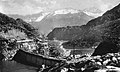
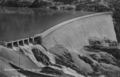
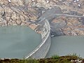
Category:Barrage de Barberine
| Object location | | View all coordinates using: OpenStreetMap |
|---|
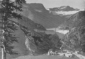
former dam in Saint-Maurice District of the canton of Valais, Switzerland  Le barrage de Barberine dans les années 1930. | |||||
| Upload media | |||||
| Instance of | |||||
|---|---|---|---|---|---|
| Location | Saint-Maurice District, Valais, Switzerland | ||||
| Located in or next to body of water | |||||
| Inception |
| ||||
| Dissolved, abolished or demolished date |
| ||||
| Mountain range | |||||
| Elevation above sea level |
| ||||
| Structure replaced by | |||||
| Different from | |||||
| Said to be the same as | Lac de Barberine | ||||
 | |||||
Media in category "Barrage de Barberine"
The following 20 files are in this category, out of 20 total.
-
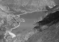
 Ancien barrage de Barberine.JPG 2,592 × 1,944; 882 KB
-
 Barberine, Barrage et bassin de retenue.png 972 × 681; 871 KB
-
 Barberine, Barrage.png 1,299 × 891; 1.55 MB
-
 Barberine, construction du barrage b.jpg 1,546 × 925; 819 KB
-
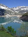
 Barberine. Lac et Barrage.png 670 × 430; 173 KB
-
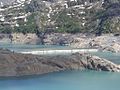
 Barrage de Barberine au 13 juillet 2013.JPG 2,592 × 1,944; 1.3 MB
-
 Barrage de barberine au 27 juin 2013.JPG 2,592 × 1,944; 1.48 MB
-
 Barrage de Barberine.JPG 2,592 × 1,944; 1.51 MB
-
 Emosson Alte Gewichtsmauer.jpg 4,912 × 3,264; 6.38 MB
-
 ETH-BIB-Barrage de Barberine (Finhaut)-LBS H1-024942.tif 7,818 × 5,535; 123.85 MB
-
 ETH-BIB-Barrage de Barberine (Finhaut)-LBS H1-024968.tif 7,760 × 5,489; 121.9 MB
-
 ETH-BIB-Barrage de Barberine (Finhaut)-LBS H1-024993.tif 6,458 × 4,504; 83.26 MB
-
 ETH-BIB-Staumauer Barberine (Détail)-Dia 247-F-00311.tif 3,672 × 2,974; 10.52 MB
-
 ETH-BIB-Staumauer Barberine (Übersicht)-Dia 247-F-00310.tif 3,094 × 3,440; 10.25 MB
-
 Lac d'Emosson 10.jpg 5,936 × 3,930; 12.15 MB
-
 Lac de Barberine, Tour Sallières et Ruan b.jpg 1,530 × 939; 821 KB
-
 Neversex's area sight to Emmosson's dam on summer, panorama - panoramio.jpg 9,132 × 4,096; 14.23 MB
-
-
-
 Tête du Largey's area sight toward "Combe des fonds" on summer - panoramio.jpg 4,896 × 3,672; 9.43 MB


