Category:Barton Turf
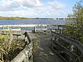
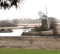
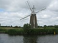
English: Barton Turf is a village and civil parish in the English county of Norfolk. The village is situated some 20 km north-east of the city of Norwich, on the northwestern edge of Barton Broad, the second largest broad of the Norfolk Broads within The Broads National Park.
village in the United Kingdom  | |||||
| Upload media | |||||
| Instance of | |||||
|---|---|---|---|---|---|
| Location | North Norfolk, Norfolk, East of England, England | ||||
| Area |
| ||||
 | |||||
Subcategories
This category has the following 3 subcategories, out of 3 total.
B
- Barton Broad (40 F)
T
- Turf Fen Mill (14 F)
Media in category "Barton Turf"
The following 182 files are in this category, out of 182 total.
-
 A Reed Cutters Boat - geograph.org.uk - 5661809.jpg 2,400 × 1,599; 692 KB
-
 Alderfen Broad, Norfolk - geograph.org.uk - 3622613.jpg 640 × 342; 61 KB
-
 Algae-covered drainage ditch, Irstead - geograph.org.uk - 2863811.jpg 480 × 640; 279 KB
-

-
 AnthonyNorris 1711-1786 of BartonTurf Norfolk.png 982 × 1,174; 1.93 MB
-
 Barton Broad - Gayes Staithe 1980 - geograph.org.uk - 2793171.jpg 640 × 458; 96 KB
-
 Barton Broad and Viewpoint - geograph.org.uk - 5587731.jpg 640 × 480; 99 KB
-
 Barton Broad Boardwalk - geograph.org.uk - 5587728.jpg 640 × 480; 130 KB
-
 Barton Turf - geograph.org.uk - 561991.jpg 640 × 478; 147 KB
-
 Barton Turf parish staithe - geograph.org.uk - 967077.jpg 640 × 427; 117 KB
-

-
 Barton Turf staithe - geograph.org.uk - 561992.jpg 478 × 640; 172 KB
-
 Barton Turf Staithe in 2002 - geograph.org.uk - 960658.jpg 640 × 331; 82 KB
-
 Barton Turf War Memorial - geograph.org.uk - 4774400.jpg 3,456 × 2,592; 3.23 MB
-
 Barton Turf WW1 War memorial - geograph.org.uk - 4774407.jpg 2,592 × 3,456; 3.09 MB
-
 Barton Turf, St. Michael's Church - geograph.org.uk - 6058752.jpg 4,056 × 6,083; 6.67 MB
-
 Barton Turf, St. Michael's Church, Blocked south porch - geograph.org.uk - 6060532.jpg 5,951 × 3,967; 6.68 MB
-

-
 Barton Turf, St. Michael's Church, Flushwork detail - geograph.org.uk - 6060536.jpg 4,440 × 6,659; 6.59 MB
-

-

-

-
-
 Barton Turf, St. Michael's Church, North buttress detail - geograph.org.uk - 6060535.jpg 5,393 × 3,595; 4.77 MB
-
-
-

-

-

-

-

-
-
 Barton Turf, St. Michael's Church, Southern aspect - geograph.org.uk - 6058784.jpg 5,268 × 3,512; 5.59 MB
-
 Barton Turf, St. Michael's Church, The altar - geograph.org.uk - 6060483.jpg 6,056 × 4,037; 4.74 MB
-
 Barton Turf, St. Michael's Church, The chapel of St. Thomas - geograph.org.uk - 6060487.jpg 4,915 × 7,374; 6.45 MB
-
 Barton Turf, St. Michael's Church, The Lych Gate - geograph.org.uk - 6058750.jpg 7,183 × 4,789; 7.75 MB
-
 Barton Turf, St. Michael's Church, The nave - geograph.org.uk - 6060528.jpg 7,363 × 4,908; 6.75 MB
-
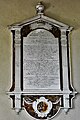 Barton Turf, St. Michael's Church, The Norris memorial - geograph.org.uk - 6060525.jpg 4,644 × 6,964; 7.58 MB
-

-
-

-

-
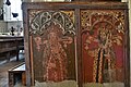
 Barton Turf, St. Michael's Church, The rood screen 1 - geograph.org.uk - 6060473.jpg 7,166 × 4,777; 7.32 MB
-
 Barton Turf, St. Michael's Church, The rood screen 2 - geograph.org.uk - 6060475.jpg 7,132 × 4,754; 7.78 MB
-

-

-

-

-

-
-

-

-
-

-

-

-
-

-

-
-
 Barton Turf, St. Michael's Church, West doorway - geograph.org.uk - 6060529.jpg 5,089 × 3,393; 5.24 MB
-
 BartonTurfDolly.jpg 1,024 × 768; 427 KB
-
-
 Berry Hall Lane, Pennygate - geograph.org.uk - 6103744.jpg 3,456 × 2,592; 3.94 MB
-
 Boathouse by the staithe - geograph.org.uk - 1146654.jpg 640 × 460; 89 KB
-
 Boatyard by the staithe - geograph.org.uk - 1146652.jpg 640 × 456; 82 KB
-
 Browns Hill - geograph.org.uk - 2863897.jpg 640 × 466; 214 KB
-
 Bus shelter on The Street - geograph.org.uk - 1146513.jpg 640 × 480; 87 KB
-
 Car park for Barton Broad - geograph.org.uk - 3590586.jpg 2,592 × 1,944; 1.06 MB
-

-
 Common Road - geograph.org.uk - 1146566.jpg 640 × 480; 112 KB
-
 Cottage by village green - geograph.org.uk - 1146671.jpg 640 × 579; 130 KB
-
 Cottage on Common Road - geograph.org.uk - 1146586.jpg 640 × 480; 76 KB
-
 Cottage on Common Road - geograph.org.uk - 1146591.jpg 640 × 480; 76 KB
-
 Cottage on The Street - geograph.org.uk - 1146680.jpg 640 × 480; 132 KB
-
 Cottages on Common Road - geograph.org.uk - 1146578.jpg 640 × 480; 77 KB
-
 Cox's Boatyard, Barton Turf - geograph.org.uk - 3329188.jpg 2,592 × 1,944; 1.36 MB
-
 Crossing a field boundary - geograph.org.uk - 1147459.jpg 640 × 480; 134 KB
-
 Cut Reeds - geograph.org.uk - 5661798.jpg 2,398 × 1,599; 706 KB
-

-
-
 Drainage pump at Callow Green - geograph.org.uk - 6103751.jpg 3,456 × 2,592; 4.05 MB
-
 Entrance to Barton Turf Adventure Centre - geograph.org.uk - 1146630.jpg 640 × 480; 104 KB
-
 Exiting the village of Barton Turf - geograph.org.uk - 1146564.jpg 640 × 480; 94 KB
-
 Farm cottages near Berry Hall - geograph.org.uk - 6103747.jpg 3,456 × 2,592; 3.92 MB
-
 Fen Turf Windpump and River Ant - geograph.org.uk - 5540853.jpg 3,944 × 2,958; 3.29 MB
-
 Field adjoining the Street - geograph.org.uk - 1146540.jpg 640 × 477; 94 KB
-
 Footpath from Smallburgh to Pennygate - geograph.org.uk - 1147561.jpg 537 × 640; 133 KB
-
 Footpath north of Berry Hall Road - geograph.org.uk - 1147455.jpg 640 × 480; 74 KB
-
 Footpath past Browns Hill Cottage - geograph.org.uk - 2863894.jpg 640 × 497; 226 KB
-
 Footpath to Browns Hill - geograph.org.uk - 2863888.jpg 640 × 480; 308 KB
-
 Frozen pond on the Green - geograph.org.uk - 1146503.jpg 640 × 480; 138 KB
-
 Grooms Cottage - geograph.org.uk - 1146527.jpg 640 × 480; 82 KB
-
 Houses on Berry Hall Road - geograph.org.uk - 1147496.jpg 640 × 480; 77 KB
-
 Houses on Staithe Road - geograph.org.uk - 1146658.jpg 640 × 448; 90 KB
-
 Ice-covered pond - geograph.org.uk - 1146675.jpg 640 × 567; 143 KB
-
 Irstead First World War Memorial - geograph.org.uk - 4774589.jpg 2,592 × 3,456; 2.54 MB
-

-
 Irstead St. Michael's church - geograph.org.uk - 2199779.jpg 640 × 480; 172 KB
-
 Irstead Staithe, River Ant - geograph.org.uk - 5587743.jpg 640 × 480; 80 KB
-
 Irstead World War Two Memorial - geograph.org.uk - 4774590.jpg 2,136 × 3,041; 1.42 MB
-

-
-

-

-
 Little house in the wood - geograph.org.uk - 3590592.jpg 2,592 × 1,944; 1.18 MB
-
 Long shadows - geograph.org.uk - 1147564.jpg 640 × 538; 120 KB
-
 Marsh pasture by Irstead - geograph.org.uk - 2863801.jpg 640 × 480; 240 KB
-
 Marshes on the other side of the gate on Irstead Street - geograph.org.uk - 6103768.jpg 3,456 × 2,592; 3.89 MB
-
 Marshland off Irstead Street - geograph.org.uk - 6103775.jpg 3,456 × 2,592; 4.01 MB
-
 Marshland off Irstead Street - geograph.org.uk - 6103777.jpg 3,456 × 2,592; 3.95 MB
-
 Moorings and boatyard on Barton Broad - geograph.org.uk - 967040.jpg 640 × 427; 108 KB
-
 Narrow path across field - geograph.org.uk - 1147557.jpg 640 × 480; 75 KB
-
 Neatishead Remote Radar Head - geograph.org.uk - 1994555.jpg 640 × 480; 65 KB
-
 Neatishead Staithe - geograph.org.uk - 5011371.jpg 2,000 × 1,500; 538 KB
-
 Neatishead Staithe - geograph.org.uk - 960699.jpg 640 × 433; 145 KB
-
 No longer a permissive path beyond the gate - geograph.org.uk - 6103770.jpg 3,456 × 2,592; 3.9 MB
-

-
 Pink cherry blossom in Berry Lane, Pennygate - geograph.org.uk - 6103745.jpg 3,456 × 2,592; 3.88 MB
-
 Pink cottages - geograph.org.uk - 1146614.jpg 640 × 480; 82 KB
-
 Ploughing the headland - geograph.org.uk - 6103717.jpg 3,456 × 2,592; 3.86 MB
-
 Private - Keep Out - geograph.org.uk - 6103763.jpg 3,456 × 2,592; 3.96 MB
-
 Racing along a field's edge - geograph.org.uk - 1147465.jpg 517 × 640; 117 KB
-
 Red-brick cottages on The Street - geograph.org.uk - 1146521.jpg 640 × 480; 91 KB
-
 Reedham Marsh near How Hill - geograph.org.uk - 3635306.jpg 640 × 420; 83 KB
-
 Reedham Marsh near How Hill - geograph.org.uk - 3635697.jpg 640 × 430; 68 KB
-
 River Ant - geograph.org.uk - 5541510.jpg 5,184 × 3,456; 7.48 MB
-
 Road liable to flooding sign on Berry Hall Road - geograph.org.uk - 6103773.jpg 3,456 × 2,592; 4 MB
-
 Road to Hall Farm, Barton Turf - geograph.org.uk - 6103754.jpg 3,456 × 2,592; 3.46 MB
-
 Scene across the arable fields off Water Lane - geograph.org.uk - 6103767.jpg 3,456 × 2,592; 3.83 MB
-
-
 St Michael's church in Barton Turf - geograph.org.uk - 1995077.jpg 640 × 521; 122 KB
-
 St Michael's church in Barton Turf - geograph.org.uk - 1995079.jpg 501 × 640; 115 KB
-

-

-

-

-

-
 Staithe House - geograph.org.uk - 1146643.jpg 640 × 480; 98 KB
-
 Straw bales - geograph.org.uk - 1147502.jpg 640 × 480; 74 KB
-

-
 Swans in drainage ditch, Irstead - geograph.org.uk - 2863814.jpg 640 × 540; 258 KB
-
 Thatched cottage on Staithe Road - geograph.org.uk - 1146620.jpg 640 × 480; 97 KB
-
 The pond at Berry Hall, Barton Turf - geograph.org.uk - 6103749.jpg 3,456 × 2,592; 3.95 MB
-

-
 Timber at Workhouse Common - geograph.org.uk - 5850710.jpg 800 × 533; 153 KB
-
 Track to Callow Green - geograph.org.uk - 6103753.jpg 3,456 × 2,592; 4.26 MB
-
 Tree casting its shadow - geograph.org.uk - 1147471.jpg 640 × 586; 124 KB
-
 Trees growing beside drain - geograph.org.uk - 1147556.jpg 640 × 480; 114 KB
-
 Trees growing on field boundary - geograph.org.uk - 1147559.jpg 640 × 480; 118 KB
-
 Turf Fen drainage mill - geograph.org.uk - 2812400.jpg 640 × 583; 189 KB
-
 Turf Fen Drainage Mill - geograph.org.uk - 3723121.jpg 480 × 640; 65 KB
-
 Turf Fen Drainage Mill - geograph.org.uk - 4032900.jpg 640 × 480; 55 KB
-
 Turf Fen Drainage Mill, How Hill - geograph.org.uk - 2079241.jpg 800 × 531; 85 KB
-
 Turf Fen Drainage Mill, How Hill - geograph.org.uk - 2079244.jpg 800 × 531; 72 KB
-
 Turf Fen Drainage Mill, How Hill - geograph.org.uk - 2079250.jpg 800 × 531; 67 KB
-
 Turf Fen Drainage Mill, How Hill - geograph.org.uk - 2079256.jpg 800 × 536; 64 KB
-
 Underside of 'Unidentified fungus' - geograph.org.uk - 2000356.jpg 640 × 480; 78 KB
-
 Unidentified Fungus - geograph.org.uk - 1992909.jpg 640 × 480; 111 KB
-
 Victorian Post box in Pennygate - geograph.org.uk - 6103743.jpg 3,456 × 2,592; 3.94 MB
-
 Victorian Post box on Berry Hall Road, Pennygate - geograph.org.uk - 6103742.jpg 2,592 × 3,456; 3.24 MB
-
 View across a winter cereal crop - geograph.org.uk - 1147493.jpg 640 × 548; 85 KB
-
 View across the village green - geograph.org.uk - 1146599.jpg 640 × 480; 110 KB
-
 View from How Hill, Ludham - geograph.org.uk - 2812398.jpg 640 × 389; 143 KB
-
 View north along Common Road - geograph.org.uk - 1146573.jpg 640 × 480; 101 KB
-
 View north along The Street - geograph.org.uk - 1146531.jpg 640 × 480; 78 KB
-
 View west along Staithe Road - geograph.org.uk - 1146625.jpg 640 × 480; 66 KB
-

-
 Village shop - Neatisham - geograph.org.uk - 561987.jpg 640 × 478; 139 KB
-
 Village sign - detail - geograph.org.uk - 1146695.jpg 640 × 590; 238 KB
-
 Village sign - geograph.org.uk - 1146692.jpg 480 × 640; 132 KB
-
 Village sign for Barton Turf and Pennygate Staithe - geograph.org.uk - 6103755.jpg 3,456 × 2,592; 3.99 MB
-
 West On Beeston Lane - geograph.org.uk - 548539.jpg 640 × 480; 141 KB
-
 Wet tracks in cereal field - geograph.org.uk - 1147560.jpg 640 × 480; 130 KB
-
 Wet woodland in Heron Carr - geograph.org.uk - 5850709.jpg 1,600 × 1,067; 644 KB
-

-
 An attractive red-brick cottage - geograph.org.uk - 1146639.jpg 640 × 480; 98 KB
-
 Barton Turf boathouse - geograph.org.uk - 561995.jpg 640 × 478; 134 KB
-
 Moorings - Barton Turf - geograph.org.uk - 561993.jpg 640 × 478; 184 KB
-
 Onto the broads - geograph.org.uk - 561994.jpg 640 × 478; 124 KB
-

-
 The Staithe, Barton Turf - geograph.org.uk - 357965.jpg 640 × 480; 80 KB


_-_geograph.org.uk_-_6060491.jpg)

_-_geograph.org.uk_-_6060493.jpg)


_-_geograph.org.uk_-_6060514.jpg)
_-_geograph.org.uk_-_6060516.jpg)


_-_geograph.org.uk_-_6060507.jpg)


_-_geograph.org.uk_-_1995086.jpg)
_-_geograph.org.uk_-_1995088.jpg)


