Category:Bauernhaus (Dorf 44, Diemtigen)
| Object location | | View all coordinates using: OpenStreetMap |
|---|
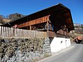
rural residential building in Diemtigen in the canton of Bern, Switzerland  | |||||
| Upload media | |||||
| Instance of | |||||
|---|---|---|---|---|---|
| Part of | |||||
| Location | Diemtigen, Frutigen-Niedersimmental administrative district, Oberland administrative region, Bern, Switzerland | ||||
| Street address |
| ||||
| Heritage designation |
| ||||
| Inception |
| ||||
 | |||||
Media in category "Bauernhaus (Dorf 44, Diemtigen)"
This category contains only the following file.
-
 Diemtigen Dorf 44.jpg 4,608 × 3,456; 6.62 MB