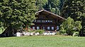
Category:Bauernhaus Obere Walkenmatte (Walkenmatte 13, Horboden)
| Object location | | View all coordinates using: OpenStreetMap |
|---|
rural residential building in Diemtigen in the canton of Bern, Switzerland .jpg) | |||||
| Upload media | |||||
| Instance of | |||||
|---|---|---|---|---|---|
| Part of | |||||
| Location | Diemtigen, Frutigen-Niedersimmental administrative district, Oberland administrative region, Bern, Switzerland | ||||
| Street address |
| ||||
| Heritage designation |
| ||||
| Inception |
| ||||
 | |||||
Media in category "Bauernhaus Obere Walkenmatte (Walkenmatte 13, Horboden)"
The following 4 files are in this category, out of 4 total.
-
 Walkenmatte 13 BE 01 (cropped).jpg 3,635 × 2,150; 7.84 MB
-
 Walkenmatte 13 BE 01.jpg 4,544 × 2,688; 12.15 MB
-
 Walkenmatte 13 BE 02 (cropped).jpg 3,539 × 1,990; 6.75 MB
-
 Walkenmatte 13 BE 02.jpg 4,424 × 2,488; 10.24 MB
.jpg)

