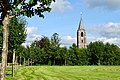
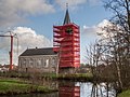
Category:Benedictuskerk, Kootstertille
| Object location | | View all coordinates using: OpenStreetMap |
|---|
church building in Achtkarspelen, Netherlands  | |||||
| Upload media | |||||
| Instance of | |||||
|---|---|---|---|---|---|
| Dedicated to | |||||
| Location | Kootstertille, Achtkarspelen, Friesland, Netherlands | ||||
| Street address |
| ||||
| Located on street |
| ||||
| Heritage designation |
| ||||
| Inception |
| ||||
| official website | |||||
 | |||||
|
This is a category about rijksmonument number 7048
|
| Address |
|
Media in category "Benedictuskerk, Kootstertille"
The following 23 files are in this category, out of 23 total.
-
 20210824 Benedictuskerk1 Koatstertille.jpg 4,102 × 2,735; 2.53 MB
-
 20210824 Benedictuskerk2 Koatstertille.jpg 3,456 × 5,184; 4.02 MB
-
 Exterieur naar het westen - Kooten - 20126942 - RCE.jpg 954 × 1,200; 284 KB
-
 Hervormde kerk Kootstertille.jpg 3,648 × 2,736; 5.05 MB
-
 Interieur naar het oosten - Kooten - 20126943 - RCE.jpg 1,200 × 953; 201 KB
-
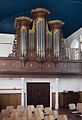 Interieur, aanzicht orgel, orgelnummer 798 - Kootstertille - 20417371 - RCE.jpg 817 × 1,200; 163 KB
-
 Kerk van Kootstertille in de stijgers.jpg 2,309 × 1,732; 1.04 MB
-
 Koatstertille, Benediktustsjerke, keunstwurk.jpg 3,050 × 3,915; 4.91 MB
-
 Koatstertille, Benediktustsjerke.jpg 5,273 × 3,770; 6.77 MB
-
 Kootstertille Klokkenstoel 2010.JPG 4,000 × 3,000; 6.91 MB
-
 Kootstertille NH-kerk.JPG 3,264 × 2,448; 4.14 MB
-
 Noordgevel - Kootstertille - 20126947 - RCE.jpg 1,190 × 1,200; 430 KB
-
 Overzicht - Kootstertille - 20126952 - RCE.jpg 1,190 × 1,200; 344 KB
-
 Overzicht - Kootstertille - 20126953 - RCE.jpg 1,195 × 1,200; 370 KB
-
 Overzicht - Kootstertille - 20126954 - RCE.jpg 1,195 × 1,200; 404 KB
-
 Overzicht - Kootstertille - 20126955 - RCE.jpg 1,190 × 1,200; 420 KB
-
 Overzicht toren - Kootstertille - 20126944 - RCE.jpg 1,195 × 1,200; 462 KB
-
 Toren noord-west zijde - Kootstertille - 20126951 - RCE.jpg 1,188 × 1,200; 291 KB
-
 Toren zuid-west zijde - Kootstertille - 20126950 - RCE.jpg 1,197 × 1,200; 287 KB
-
 Torenvoet - Kootstertille - 20126949 - RCE.jpg 1,200 × 1,197; 445 KB
-
 Zuid-oost gevel - Kootstertille - 20126945 - RCE.jpg 1,193 × 1,200; 332 KB
-
 Zuid-oost gevel - Kootstertille - 20126948 - RCE.jpg 1,188 × 1,200; 410 KB
-
 Zuidgevel - Kootstertille - 20126946 - RCE.jpg 1,200 × 1,200; 441 KB


