Category:Berrigan Shire
English: Berrigan Shire
local government area in New South Wales, Australia  | |||||
| Upload media | |||||
| Instance of | |||||
|---|---|---|---|---|---|
| Location | New South Wales, AUS | ||||
| Located in or next to body of water | |||||
| Capital | |||||
| Legislative body |
| ||||
| Inception |
| ||||
| Highest point |
| ||||
| Population |
| ||||
| Area |
| ||||
| Elevation above sea level |
| ||||
| official website | |||||
 | |||||
Subcategories
This category has the following 7 subcategories, out of 7 total.
Media in category "Berrigan Shire"
The following 9 files are in this category, out of 9 total.
-
 Australia-Map-NSW-LGA-Berrigan.png 720 × 593; 29 KB
-
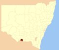 Berrigan LGA NSW.png 400 × 337; 33 KB
-
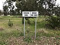 Berrigan Shire Federation Council Municipal Boundary Sign.JPG 4,032 × 3,024; 5.54 MB
-
 Berrigan Yarrawonga Road Road Construction 001.JPG 6,016 × 4,000; 11.27 MB
-
 Berrigan Yarrawonga Road Road Construction 002.JPG 6,016 × 4,000; 9.44 MB
-
 Berrigan Yarrawonga Road Road Construction 003.JPG 6,016 × 4,000; 9.98 MB
-
 Berrigan Yarrawonga Road Road Construction 004.JPG 6,016 × 4,000; 10.77 MB
-
 Finley Water Towers.JPG 5,408 × 3,560; 7 MB
-
 WelcomeToTheBerriganShire.JPG 2,962 × 2,100; 1.42 MB


