Category:Bird's eye view maps of Maine
Subcategories
This category has only the following subcategory.
Media in category "Bird's eye view maps of Maine"
The following 17 files are in this category, out of 17 total.
-
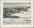
 Birds eye view of Casco Bay, Portland, Maine, and surroundings (2675108052).jpg 1,268 × 2,000; 2.15 MB
-
 Birds eye view of the village of Wiscasset, Lincoln Co., Maine, 1878 (4584054514).jpg 2,000 × 1,475; 2.53 MB
-
 Birds eye view of Waterville, Kennebec Co. Maine (2675086849).jpg 2,000 × 1,409; 2.36 MB
-
 Deering, Cumberland County, Maine (2675893654).jpg 2,000 × 1,619; 2.87 MB
-
 Dover & Foxcroft (2675894532).jpg 2,000 × 1,255; 1.96 MB
-

-

-
 Fort Fairfield, Maine (2675079469).jpg 2,000 × 1,663; 2.28 MB
-
 Greens Landing, Me. (2675075381).jpg 2,000 × 1,663; 2.3 MB
-
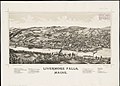 Livermore Falls, Maine (2675897410).jpg 2,000 × 1,441; 1.95 MB
-
 Monson, Maine (2675080893).jpg 2,000 × 1,389; 1.85 MB
-
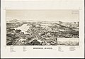
 Pittsfield, Maine (2675898818).jpg 2,000 × 1,412; 2.02 MB
-
 Sanford, Maine (2675083199).jpg 2,000 × 1,386; 1.88 MB
-
 Skowhegan, Me. (2675901242).jpg 2,000 × 1,319; 2.09 MB
-
 Springvale, Maine (2675084727).jpg 2,000 × 1,382; 1.72 MB
-
 St. Stephen, New Brunswick and Calais, Maine (2675890254).jpg 2,000 × 1,421; 2.8 MB
-
 Vinalhaven, Me. (2675885706).jpg 2,000 × 1,662; 2.46 MB
.jpg)
.jpg)
.jpg)
.jpg)
.jpg)
.jpg)
.jpg)
.jpg)
.jpg)
.jpg)
.jpg)
.jpg)
.jpg)
.jpg)
.jpg)
.jpg)
.jpg)