Category:Birmingham Union workhouse
| Object location | | View all coordinates using: OpenStreetMap |
|---|
former workhouse in Birmingham, England  | |||||
| Upload media | |||||
| Instance of | |||||
|---|---|---|---|---|---|
| Location | Birmingham, West Midlands, England | ||||
| Architect | |||||
 | |||||
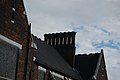
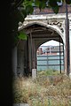
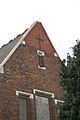
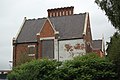
English: The former Birmingham Union workhouse, in the grounds of the later City Hospital. The derelict building was demolished in 2017.
Media in category "Birmingham Union workhouse"
The following 29 files are in this category, out of 29 total.
-
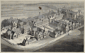 Birmingham New Workhouse, England, c.1852.png 1,197 × 747; 2.1 MB
-
 Birmingham Workhouse 01.JPG 2,000 × 3,008; 2.39 MB
-
 Birmingham Workhouse 02 CROP.JPG 2,452 × 1,689; 1.95 MB
-
 Birmingham Workhouse 02.JPG 3,008 × 2,000; 2.73 MB
-
 Birmingham Workhouse 03.JPG 3,008 × 2,000; 2.63 MB
-
 Birmingham Workhouse 04.JPG 3,008 × 2,000; 2.32 MB
-
 Birmingham Workhouse 05.JPG 3,008 × 2,000; 1.97 MB
-
 Birmingham Workhouse 06.JPG 3,008 × 2,000; 1.94 MB
-
 Birmingham Workhouse 07.JPG 3,008 × 2,000; 2.4 MB
-
 Birmingham Workhouse 08.JPG 2,000 × 3,008; 2.36 MB
-
 Birmingham Workhouse 09.JPG 3,008 × 2,000; 2.46 MB
-
 Birmingham Workhouse 10.JPG 3,008 × 2,000; 2.06 MB
-
 Birmingham Workhouse 11.JPG 3,008 × 2,000; 2.2 MB
-
 Birmingham Workhouse 12.JPG 3,008 × 2,000; 2.22 MB
-
 Birmingham Workhouse 13.JPG 3,008 × 2,000; 2.32 MB
-
 Birmingham Workhouse 14.JPG 2,000 × 3,008; 2.72 MB
-
 Birmingham Workhouse 15.JPG 2,000 × 3,008; 2.67 MB
-
 Birmingham Workhouse 16.JPG 2,000 × 3,008; 2.6 MB
-
 Birmingham Workhouse 17.JPG 3,008 × 2,000; 2.1 MB
-
 Birmingham Workhouse 18.JPG 3,008 × 2,000; 2.63 MB
-
 Birmingham Workhouse 19.JPG 3,008 × 2,000; 2.37 MB
-
 Birmingham Workhouse 20.JPG 2,000 × 3,008; 2.33 MB
-
 Birmingham Workhouse 21.JPG 2,000 × 3,008; 2.62 MB
-
 Birmingham Workhouse 22.JPG 3,008 × 2,000; 2.65 MB
-
 Birmingham Workhouse 23.JPG 3,008 × 2,000; 2.68 MB
-
 Birmingham Workhouse site - Andy Mabbett - 2017-09-15 - 01.jpg 3,872 × 2,592; 3.39 MB
-
 Birmingham Workhouse site - Andy Mabbett - 2017-09-15 - 02.jpg 3,872 × 2,592; 4.45 MB
-
 Birmingham Workhouse site - Andy Mabbett - 2017-09-15 - 03.jpg 3,872 × 2,592; 3.87 MB
-
 Birmingham Workhouse site - Andy Mabbett - 2017-09-15 - 04.jpg 3,872 × 2,592; 4.21 MB


