Category:Blacktoft
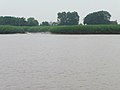
English: Blacktoft is a village and civil parish in the East Riding of Yorkshire, England. It is situated on the north bank of the River Ouse, not far from where it flows into the River Trent and becomes the Humber. It is approximately 6 miles (9.7 km) east of Goole town centre.
village in the East Riding of Yorkshire, England, UK  | |||||
| Upload media | |||||
| Instance of | |||||
|---|---|---|---|---|---|
| Location | East Riding of Yorkshire, Yorkshire and the Humber, England | ||||
| Said to be the same as | Blacktoft (Wikimedia duplicated page, civil parish) | ||||
 | |||||
Subcategories
This category has the following 9 subcategories, out of 9 total.
B
- Bellasize (3 F)
F
- Faxfleet Grange (5 F)
H
- Holy Trinity Church, Blacktoft (21 F)
O
- Oxmardyke level crossing (5 F)
R
- River Ouse at Blacktoft (17 F)
W
Y
Media in category "Blacktoft"
The following 200 files are in this category, out of 480 total.
(previous page) (next page)-
 A Country Road - geograph.org.uk - 250354.jpg 639 × 479; 101 KB
-
 A course of the River Humber - geograph.org.uk - 3688018.jpg 1,024 × 692; 114 KB
-
 A Harrow - geograph.org.uk - 253389.jpg 638 × 480; 101 KB
-
 A Metal Shed - geograph.org.uk - 253388.jpg 636 × 480; 103 KB
-
 A minor road to Yokefleet - geograph.org.uk - 2209017.jpg 800 × 600; 186 KB
-
 A really tall pylon - geograph.org.uk - 5702318.jpg 480 × 640; 21 KB
-

-
 A Tidy Field - geograph.org.uk - 250350.jpg 640 × 480; 101 KB
-
 A Track Across The Warwicks - geograph.org.uk - 250196.jpg 640 × 480; 106 KB
-
 A wet day north of Faxfleet - geograph.org.uk - 6176006.jpg 1,024 × 768; 147 KB
-
 Access road to Bellasize Grange - geograph.org.uk - 6186380.jpg 4,608 × 3,456; 4.98 MB
-
 Acres of reeds at Faxfleet Ness - geograph.org.uk - 3786979.jpg 640 × 427; 69 KB
-
 Across A Field To Blacktoft House - geograph.org.uk - 253236.jpg 640 × 480; 97 KB
-
 After the Harvest - geograph.org.uk - 2037390.jpg 3,648 × 2,736; 5.9 MB
-
 Alkborough from Faxfleet - geograph.org.uk - 381319.jpg 640 × 480; 67 KB
-
 All Pylon - geograph.org.uk - 2037446.jpg 2,562 × 3,024; 1.86 MB
-
 An Artificial Pond - geograph.org.uk - 253386.jpg 640 × 480; 100 KB
-
 An Avenue Of Trees - geograph.org.uk - 253378.jpg 640 × 480; 103 KB
-
 Another Field Prepared - geograph.org.uk - 250352.jpg 640 × 480; 100 KB
-
 Anserdam Drain and the bridleway to Blacktoft - geograph.org.uk - 3721191.jpg 1,024 × 768; 138 KB
-
 Apex of the tidal pond, Trent Falls - geograph.org.uk - 3597321.jpg 1,024 × 768; 125 KB
-
 Approaching Oxmardyke Crossing - geograph.org.uk - 5699634.jpg 640 × 461; 47 KB
-
 Approaching Sober Hill - geograph.org.uk - 253256.jpg 640 × 480; 103 KB
-
 Approaching Weighton Lock - geograph.org.uk - 3688110.jpg 1,024 × 768; 167 KB
-
 Approaching Weighton Lock and Humber Lock Farm - geograph.org.uk - 5282077.jpg 5,256 × 2,792; 2.16 MB
-
 Arable field, west of Bellasize Grange - geograph.org.uk - 5675948.jpg 1,024 × 614; 189 KB
-
 Are there wise owls at Faxfleet^ - geograph.org.uk - 5282060.jpg 5,376 × 3,024; 3.03 MB
-
 Arriving at Blacktoft from Faxfleet - geograph.org.uk - 3787177.jpg 640 × 427; 51 KB
-
 Barn at Ella Farm, Yokefleet - geograph.org.uk - 3673182.jpg 1,024 × 768; 179 KB
-
 Barn at Manor House Farm, Blacktoft - geograph.org.uk - 5049778.jpg 1,200 × 799; 367 KB
-
 Barn at Sober Hill Farm - geograph.org.uk - 5049022.jpg 1,200 × 720; 391 KB
-
 Beeches Farm - geograph.org.uk - 6021775.jpg 640 × 480; 86 KB
-

-
 Bellasize Drain - geograph.org.uk - 939378.jpg 640 × 480; 117 KB
-
 Bellasize Drain near Blacktoft - geograph.org.uk - 5049983.jpg 1,200 × 799; 378 KB
-
 Bellasize Drain, Blacktoft - geograph.org.uk - 635697.jpg 640 × 439; 105 KB
-
 Bellasize Drain, west of Blacktoft - geograph.org.uk - 860401.jpg 640 × 322; 162 KB
-

-
 Bellasize Lane and Mill Lane junction - geograph.org.uk - 6186389.jpg 4,608 × 3,456; 5.9 MB
-
 Bellasize Lane toward Black Bridge - geograph.org.uk - 6180728.jpg 4,608 × 3,456; 4.35 MB
-
 Bellasize Lane, heading east - geograph.org.uk - 5675953.jpg 1,024 × 614; 163 KB
-
 Bellasize Lane, heading west to Black Bridge - geograph.org.uk - 5675231.jpg 1,024 × 614; 130 KB
-
 Bench by the River Ouse - geograph.org.uk - 6021758.jpg 640 × 480; 74 KB
-

-
 Bishopsoil Drain entering the River Ouse - geograph.org.uk - 3589488.jpg 1,024 × 768; 93 KB
-
 Blacktoft Clough - geograph.org.uk - 635694.jpg 453 × 640; 89 KB
-
 Blacktoft Clough Bridge - geograph.org.uk - 739928.jpg 640 × 480; 107 KB
-
 Blacktoft Clough, north bank of the River Ouse - geograph.org.uk - 3586201.jpg 1,024 × 768; 137 KB
-
 Blacktoft Jetty - geograph.org.uk - 1876361.jpg 4,000 × 3,000; 2.34 MB
-
 Blacktoft Lane - geograph.org.uk - 1168743.jpg 640 × 480; 145 KB
-
 Blacktoft Lane - geograph.org.uk - 5281766.jpg 5,198 × 2,654; 2.3 MB
-
 Blacktoft Lane, Blacktoft - geograph.org.uk - 808344.jpg 640 × 442; 205 KB
-
 Blacktoft Lane, near Blacktoft - geograph.org.uk - 5264646.jpg 480 × 640; 167 KB
-
 Blacktoft Lane, Yokefleet - geograph.org.uk - 5050207.jpg 1,200 × 799; 433 KB
-
 Blacktoft Lane, Yokefleet - geograph.org.uk - 5264355.jpg 640 × 481; 172 KB
-

-
 Blacktoft Pier - panoramio.jpg 3,264 × 2,448; 3.71 MB
-
 Blacktoft to Broomfleet - geograph.org.uk - 860423.jpg 640 × 480; 260 KB
-
 Blacktoft UK parish locator map.svg 1,425 × 1,107; 1.68 MB
-
 Blacktoft Warping Drain - geograph.org.uk - 1603666.jpg 640 × 480; 95 KB
-
 Blacktoft Warping Drain - geograph.org.uk - 3721258.jpg 1,024 × 768; 158 KB
-
 Blacktoft Warping Drain enters the River Ouse - geograph.org.uk - 3718191.jpg 1,024 × 768; 122 KB
-

-
 Blacktoft Warping Drain, Blacktoft - geograph.org.uk - 5049822.jpg 1,200 × 799; 446 KB
-
 Bosky embankment - geograph.org.uk - 3688831.jpg 1,024 × 768; 153 KB
-
 Brickyard Pond, Broomfleet - geograph.org.uk - 3142530.jpg 640 × 427; 80 KB
-

-
 Bridge over the canal, near Broomfleet - geograph.org.uk - 4609846.jpg 640 × 472; 391 KB
-
 Bridge over the Market Weighton Canal - geograph.org.uk - 5437750.jpg 800 × 600; 136 KB
-
 Bridleway leading to Blacktoft - geograph.org.uk - 5049055.jpg 1,200 × 799; 334 KB
-
 Bridleway leading to Blacktoft - geograph.org.uk - 5049066.jpg 1,200 × 799; 326 KB
-
 Bridleway leading to Blacktoft - geograph.org.uk - 5049110.jpg 1,200 × 799; 325 KB
-
 Bridleway leading to Blacktoft - geograph.org.uk - 5049113.jpg 1,200 × 799; 362 KB
-
 Bridleway leading to Blacktoft - geograph.org.uk - 5049115.jpg 1,200 × 799; 357 KB
-
 Bridleway leading to Blacktoft - geograph.org.uk - 5049123.jpg 1,200 × 799; 411 KB
-
 Bridleway off Bellasize Lane - geograph.org.uk - 5048972.jpg 1,200 × 799; 296 KB
-
 Bridleway towards Sober Hill - geograph.org.uk - 5048975.jpg 1,200 × 799; 381 KB
-
 Bridleway towards Sober Hill - geograph.org.uk - 5048977.jpg 1,200 × 799; 292 KB
-
 Bridleway towards Sober Hill - geograph.org.uk - 5048984.jpg 1,200 × 799; 361 KB
-
 Bridleway towards Sober Hill - geograph.org.uk - 5049008.jpg 1,200 × 799; 383 KB
-
 Bridleway towards Sober Hill Farm - geograph.org.uk - 6175984.jpg 1,024 × 768; 187 KB
-
 Building in Yokefleet Park - geograph.org.uk - 3673179.jpg 1,024 × 768; 200 KB
-
 Building off Hutch Lane, Yokefleet - geograph.org.uk - 5050183.jpg 1,200 × 799; 405 KB
-
 Buildings near Riverside Farm - geograph.org.uk - 3786987.jpg 640 × 427; 64 KB
-
 Byway to Oxmardyke Grange - geograph.org.uk - 3786610.jpg 640 × 427; 65 KB
-

-

-
 Chapel Cottage, Blacktoft - geograph.org.uk - 6021726.jpg 640 × 478; 63 KB
-
 Chasing the tide at Trent Falls - geograph.org.uk - 5699599.jpg 640 × 480; 56 KB
-
 Church of Holy Trinity - geograph.org.uk - 6021756.jpg 640 × 456; 114 KB
-
 Clearing the drain - geograph.org.uk - 3688735.jpg 1,024 × 768; 111 KB
-
 Clough House - geograph.org.uk - 6021764.jpg 640 × 480; 91 KB
-
 Clough House from river bank - geograph.org.uk - 2185740.jpg 4,000 × 3,000; 3.2 MB
-
 Commemorative stone at Weighton Lock - geograph.org.uk - 5281811.jpg 5,376 × 2,674; 2.66 MB
-

-
 Contracting Farmland - geograph.org.uk - 253380.jpg 640 × 480; 101 KB
-
 Corner of lane south east of Faxfleet Grange - geograph.org.uk - 3133075.jpg 4,608 × 3,072; 3.19 MB
-

-

-
 Derelict shed at Mill Farm - geograph.org.uk - 5442725.jpg 800 × 600; 143 KB
-
 Dilapidated shed at Riverside Farm - geograph.org.uk - 3687987.jpg 1,024 × 768; 167 KB
-
 Disused gate - geograph.org.uk - 3717813.jpg 1,024 × 768; 202 KB
-
 Drain beside Greenoak Lane - geograph.org.uk - 1603702.jpg 640 × 480; 79 KB
-
 Drain entering Greenoak Goit - geograph.org.uk - 5675975.jpg 1,024 × 768; 247 KB
-
 Drain from Yokefleet to the River Ouse - geograph.org.uk - 1873683.jpg 4,000 × 3,000; 3.87 MB
-
 Drain north of Faxfleet - geograph.org.uk - 3688721.jpg 1,024 × 768; 150 KB
-
 Drain on the north side of Bellasize Lane - geograph.org.uk - 5675961.jpg 1,024 × 768; 229 KB
-
 Drain outfall, north bank of the River Ouse - geograph.org.uk - 3586148.jpg 1,024 × 768; 87 KB
-

-
 East Lodge and gateway - geograph.org.uk - 5442734.jpg 800 × 600; 143 KB
-
 Electricity pylon - geograph.org.uk - 5442616.jpg 800 × 600; 98 KB
-
 Electricity pylon near Blacktoft - geograph.org.uk - 6021717.jpg 640 × 492; 48 KB
-
 Electricity Pylon, Tongue Lane - geograph.org.uk - 1603558.jpg 516 × 640; 46 KB
-
 Electricity Pylons - geograph.org.uk - 1603380.jpg 640 × 480; 36 KB
-
 Embankment east of Faxfleet - geograph.org.uk - 5699608.jpg 640 × 480; 93 KB
-
 Entering Blacktoft - geograph.org.uk - 3133067.jpg 4,608 × 3,072; 3.08 MB
-
 Entering Blacktoft, East Yorkshire - geograph.org.uk - 2291627.jpg 800 × 600; 328 KB
-
 Entering Faxfleet, East Yorkshire - geograph.org.uk - 2291629.jpg 800 × 600; 282 KB
-

-

-

-
 Far Drain - geograph.org.uk - 3718213.jpg 1,024 × 768; 150 KB
-
 Far Drain at Thornton Lands - geograph.org.uk - 5699601.jpg 640 × 480; 81 KB
-

-
 Farm access road at Warwick House - geograph.org.uk - 5050458.jpg 1,200 × 799; 375 KB
-
 Farm access road at Warwick House - geograph.org.uk - 5050461.jpg 1,200 × 799; 322 KB
-
 Farm Track and Hall Farm - geograph.org.uk - 1875731.jpg 4,000 × 3,000; 2.79 MB
-
 Farm track leading to Warwick House - geograph.org.uk - 5050257.jpg 1,200 × 799; 384 KB
-
 Farm track to North Field - geograph.org.uk - 1875818.jpg 4,000 × 3,000; 3.13 MB
-
 Farm track to Staddlethorpe Broad Lane - geograph.org.uk - 3721209.jpg 1,024 × 768; 125 KB
-
 Farm track towards Warwick House - geograph.org.uk - 5050339.jpg 1,200 × 799; 382 KB
-
 Farm track towards Warwick House - geograph.org.uk - 5050352.jpg 1,200 × 799; 393 KB
-
 Farm track towards Warwick House - geograph.org.uk - 5050434.jpg 1,200 × 799; 417 KB
-
 Farmland at SE838278 - geograph.org.uk - 121390.jpg 640 × 480; 157 KB
-
 Farmland at SE849276 - geograph.org.uk - 115316.jpg 640 × 480; 111 KB
-
 Farmland between Eastfield and Lodge Farms - geograph.org.uk - 5675222.jpg 1,024 × 615; 144 KB
-
 Farmland East of Staddlethorpe - geograph.org.uk - 1603540.jpg 640 × 480; 41 KB
-
 Farmland south of Bellasize Lane - geograph.org.uk - 5675240.jpg 1,024 × 768; 243 KB
-
 Faxfleet from across the Humber near sunset - geograph.org.uk - 1894030.jpg 1,600 × 1,200; 266 KB
-

-
 Faxfleet Main Drain outflow - geograph.org.uk - 3141310.jpg 640 × 427; 94 KB
-

-
 Faxfleet Ness and Trent Falls - geograph.org.uk - 860445.jpg 640 × 341; 154 KB
-
 Faxfleet Ness, north bank, River Ouse - geograph.org.uk - 3589515.jpg 1,024 × 768; 89 KB
-
 Faxfleet Ness, with waders on the mud - geograph.org.uk - 3589519.jpg 1,024 × 614; 64 KB
-
 Faxfleet, East Yorkshire - geograph.org.uk - 2208627.jpg 800 × 600; 263 KB
-
 Field access near Faxfleet Drain - geograph.org.uk - 6176008.jpg 1,024 × 768; 144 KB
-
 Field boundary - geograph.org.uk - 3718173.jpg 1,024 × 768; 169 KB
-

-
 Field Drain - geograph.org.uk - 1603527.jpg 640 × 480; 95 KB
-
 Field drain near Blacktoft - geograph.org.uk - 6175996.jpg 1,024 × 768; 144 KB
-
 Field drain near Staddlethorpe - geograph.org.uk - 3721229.jpg 1,024 × 768; 198 KB
-
 Field, pylon, bush and drain - geograph.org.uk - 252801.jpg 640 × 480; 103 KB
-
 Fields by Low Meatham - geograph.org.uk - 6020345.jpg 1,024 × 768; 183 KB
-
 Fields off Staddlethorpe Broad Lane - geograph.org.uk - 1369731.jpg 640 × 480; 84 KB
-
 Fields towards Tongue Lane - geograph.org.uk - 1369741.jpg 640 × 480; 47 KB
-
 Flat Green and a big Sky - geograph.org.uk - 1875768.jpg 4,000 × 3,000; 2.77 MB
-
 Flaxfleet Lane towards Flaxfleet - geograph.org.uk - 2208618.jpg 800 × 600; 184 KB
-

-

-
 Flood prevention work at Blacktoft - geograph.org.uk - 6021722.jpg 640 × 480; 82 KB
-
 Flood prevention work at Blacktoft - geograph.org.uk - 6021725.jpg 640 × 480; 64 KB
-
 Footbridge And Damson Bushes - geograph.org.uk - 255685.jpg 640 × 480; 107 KB
-
 Footbridge to the north of Blacktoft - geograph.org.uk - 5049199.jpg 1,200 × 799; 531 KB
-
 Footpath past Sober Hill Farm - geograph.org.uk - 2185710.jpg 4,000 × 3,000; 3.84 MB
-

-
 Fountain at the Old Vicarage, Blacktoft - geograph.org.uk - 5049242.jpg 1,200 × 799; 479 KB
-

-
 Gear box for an Archimedes Screw - geograph.org.uk - 3673152.jpg 1,024 × 768; 185 KB
-
 Gilberdyke Sewage Treatment Works - geograph.org.uk - 1369856.jpg 640 × 480; 57 KB
-
 Gilberdyke Sewage Works - geograph.org.uk - 806436.jpg 640 × 480; 181 KB
-

-

-
 Glasshouses on Staddlethorpe Broad Lane - geograph.org.uk - 6175992.jpg 1,024 × 768; 149 KB
-
-
 Gowthorpe Lane to Gowthorpe House - geograph.org.uk - 2208842.jpg 800 × 600; 200 KB
-
 Greenhouses at Sober Hill - geograph.org.uk - 5049061.jpg 1,200 × 799; 372 KB
-

-
 Greenoak Crossing from Black Bridge - geograph.org.uk - 6180739.jpg 4,608 × 3,456; 4.7 MB
-
 Greenoak Goit - geograph.org.uk - 3671667.jpg 1,024 × 768; 171 KB
-
 Greenoak Goit, north of Yokefleet - geograph.org.uk - 5675980.jpg 1,024 × 768; 237 KB
-
 Greenoak Lane Level crossing - geograph.org.uk - 1365234.jpg 640 × 480; 54 KB
-
 Hall Farm, Yokefleet - geograph.org.uk - 5050250.jpg 1,200 × 799; 313 KB
-
 Hardy holiday makers - geograph.org.uk - 3718204.jpg 1,024 × 768; 121 KB
-
 Heading down The Landing - geograph.org.uk - 2106410.jpg 800 × 600; 301 KB
-

-
 Heading south to Yokefleet - geograph.org.uk - 2209011.jpg 800 × 600; 189 KB
-
 Hedgerow on White Ings - geograph.org.uk - 3688116.jpg 1,024 × 768; 152 KB
-
 Hedgerow south of Gilberdyke - geograph.org.uk - 6021508.jpg 640 × 480; 86 KB
-
 High tide at Blacktoft Clough - geograph.org.uk - 6176000.jpg 1,024 × 768; 94 KB
-
 Holy Trinity Church, Blacktoft - geograph.org.uk - 5264366.jpg 480 × 640; 191 KB
-
 Holy Trinity, Old St Clement’s, Blacktoft - geograph.org.uk - 5281778.jpg 5,376 × 3,024; 2.36 MB
-
 Hope and Anchor pub at Blacktoft - geograph.org.uk - 5699606.jpg 640 × 480; 127 KB
-
 House in Yokefleet - geograph.org.uk - 3133063.jpg 4,188 × 2,992; 2.78 MB
-
 Houses on Blacktoft Lane, Blacktoft - geograph.org.uk - 5049815.jpg 1,200 × 799; 371 KB
-
 Houses on Blacktoft Lane, Blacktoft - geograph.org.uk - 5049819.jpg 1,200 × 799; 358 KB
-
 Houses on Blacktoft Lane, Yokefleet - geograph.org.uk - 5050203.jpg 1,200 × 799; 345 KB
-
 Houses on Blacktoft Lane, Yokefleet - geograph.org.uk - 5050244.jpg 1,200 × 799; 456 KB
-
 Humber Lock Farm - geograph.org.uk - 5974939.jpg 1,024 × 768; 178 KB
-
 Hutch Lane towards Yokefleet - geograph.org.uk - 5050173.jpg 1,200 × 799; 351 KB


_-_geograph.org.uk_-_3786703.jpg)


