Category:Boeijink Winterswijk
| Object location | | View all coordinates using: OpenStreetMap |
|---|
| Upload media | |||||
| Instance of | |||||
|---|---|---|---|---|---|
| Part of | |||||
| Location | Huppel, Winterswijk, Gelderland, Netherlands | ||||
| Street address |
| ||||
| Heritage designation |
| ||||
 | |||||
|
This is a category about rijksmonumentcomplex number 523461
|
Boerderij:
|
This is a category about rijksmonument number 523462
|
Grote houten landbouwschuur:
|
This is a category about rijksmonument number 523463
|
Houten schuur:
|
This is a category about rijksmonument number 523464
|
Koetshuis (afgebroken):
|
This is a category about rijksmonument number 523465
|
| Address |
|
Media in category "Boeijink Winterswijk"
The following 55 files are in this category, out of 55 total.
-
 Bedrijfsgedeelte - Winterswijk - 20346479 - RCE.jpg 1,190 × 1,200; 384 KB
-
 Bedrijfsgedeelte - Winterswijk - 20346480 - RCE.jpg 1,189 × 1,200; 439 KB
-
 Bedrijfsgedeelte - Winterswijk - 20346520 - RCE.jpg 1,188 × 1,200; 429 KB
-
 Bedrijfsgedeelte met rechts gedeelte gevel voorhuis - Winterswijk - 20346476 - RCE.jpg 1,190 × 1,200; 337 KB
-
 Boeijink boerderij achteraanzicht.jpg 3,648 × 2,736; 3.42 MB
-
 Boeijink boerderij gang.jpg 2,736 × 3,648; 1.72 MB
-
 Boeijink boerderij gangvloer.jpg 2,736 × 3,648; 2.01 MB
-
 Boeijink boerderij gevelsteen links.jpg 3,648 × 2,736; 2.46 MB
-
 Boeijink boerderij gevelsteen rechts.jpg 3,648 × 2,736; 2.7 MB
-
 Boeijink boerderij haard.jpg 2,736 × 3,648; 3.03 MB
-
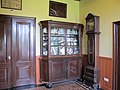 Boeijink boerderij interieur.jpg 3,648 × 2,736; 2.55 MB
-
 Boeijink boerderij vooraanzicht 1.jpg 3,648 × 2,736; 2.87 MB
-
 Boeijink boerderij vooraanzicht 2.jpg 3,648 × 2,736; 3.25 MB
-
 Boeijink schoppe achteraanzicht.jpg 3,648 × 2,736; 3.12 MB
-
 Boeijink schoppe zijaanzicht.jpg 3,648 × 2,736; 2.62 MB
-
 Boeijink schoppe.jpg 2,736 × 3,648; 3.91 MB
-
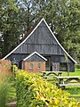
 Boeijink schuur.jpg 3,648 × 2,736; 2.98 MB
-

-
 Gedeelte zijgevel voorhuis met hekwerk - Winterswijk - 20346473 - RCE.jpg 1,188 × 1,200; 353 KB
-
 Gedeelte zijgevel voorhuis met pomp en gedenksteen - Winterswijk - 20346474 - RCE.jpg 1,187 × 1,200; 413 KB
-
 Grote schuur - Winterswijk - 20346518 - RCE.jpg 1,187 × 1,200; 420 KB
-
 Grote schuur - Winterswijk - 20346519 - RCE.jpg 1,190 × 1,200; 489 KB
-
 Hekwerk, begrenzing van het erf - Winterswijk - 20346470 - RCE.jpg 1,189 × 1,200; 451 KB
-
 Hondenhok - Winterswijk - 20346481 - RCE.jpg 1,192 × 1,200; 468 KB
-

-
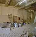
 Interieur grote schuur, kapconstructie - Winterswijk - 20346521 - RCE.jpg 1,187 × 1,200; 340 KB
-
 Interieur voorhuis, "nieuwe" keuken - Winterswijk - 20346498 - RCE.jpg 1,192 × 1,200; 190 KB
-
 Interieur voorhuis, gang - Winterswijk - 20346484 - RCE.jpg 1,191 × 1,200; 250 KB
-

-

-
 Interieur voorhuis, kelder - Winterswijk - 20346507 - RCE.jpg 1,187 × 1,200; 153 KB
-
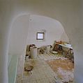
 Interieur voorhuis, oude keuken - Winterswijk - 20346486 - RCE.jpg 1,189 × 1,200; 303 KB
-
 Interieur voorhuis, oude keuken - Winterswijk - 20346488 - RCE.jpg 1,186 × 1,200; 285 KB
-
 Interieur voorhuis, oude keuken - Winterswijk - 20346500 - RCE.jpg 1,191 × 1,200; 286 KB
-
 Interieur voorhuis, oude keuken, detail schouw, links - Winterswijk - 20346490 - RCE.jpg 1,187 × 1,200; 354 KB
-

-
 Interieur voorhuis, plafond gang - Winterswijk - 20346485 - RCE.jpg 1,189 × 1,200; 190 KB
-
 Interieur voorhuis, rommelkamertje - Winterswijk - 20346499 - RCE.jpg 1,189 × 1,200; 206 KB
-

-
 Interieur voorhuis, trap naar opkamer - Winterswijk - 20346497 - RCE.jpg 1,189 × 1,200; 186 KB
-
 Interieur, 'bijkeuken" - Winterswijk - 20346501 - RCE.jpg 1,184 × 1,200; 238 KB
-
 Interieur, de deel - Winterswijk - 20346509 - RCE.jpg 1,184 × 1,200; 253 KB
-
 Interieur, stalruimte, grenzend aan de deel - Winterswijk - 20346515 - RCE.jpg 1,191 × 1,200; 265 KB
-
 Interieur, stalruimte, grenzend aan de deel - Winterswijk - 20346516 - RCE.jpg 1,191 × 1,200; 290 KB
-
 Interieur, toilet op de deel - Winterswijk - 20346502 - RCE.jpg 1,187 × 1,200; 240 KB
-
 Interieur, varkensstallen, naast de deel - Winterswijk - 20346513 - RCE.jpg 1,188 × 1,200; 252 KB
-
 Interieur, varkensstallen, naast de deel - Winterswijk - 20346514 - RCE.jpg 1,190 × 1,200; 254 KB
-
 Kleine schuur - Winterswijk - 20346517 - RCE.jpg 1,194 × 1,200; 453 KB
-
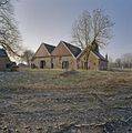
 Overzicht boerderij met schuur - Huppel - 20527949 - RCE.jpg 1,200 × 800; 267 KB
-
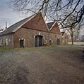
 Overzicht schuur - Huppel - 20527948 - RCE.jpg 1,200 × 800; 261 KB
-
 Overzicht schuur tijdens restauratie - Huppel - 20527950 - RCE.jpg 1,200 × 800; 286 KB
-
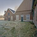
 Overzicht voorgevel van boerderij - Huppel - 20527947 - RCE.jpg 1,200 × 800; 292 KB
-
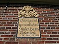
 Voorgevel voorhuis, gedenksteen - Winterswijk - 20346483 - RCE.jpg 1,195 × 1,200; 347 KB
-
 Voorhuis, voorgevel - Winterswijk - 20346471 - RCE.jpg 1,187 × 1,200; 419 KB
-
 Zijgevel voorhuis, gedenksteen - Winterswijk - 20346482 - RCE.jpg 1,194 × 1,200; 324 KB


_-_Winterswijk_-_20346496_-_RCE.jpg)


