Category:Boerhaavehuis, Voorhout
| Object location | | View all coordinates using: OpenStreetMap |
|---|
 | |||||
| Upload media | |||||
| Instance of | |||||
|---|---|---|---|---|---|
| Named after | |||||
| Location | Voorhout, South Holland, Netherlands | ||||
| Street address |
| ||||
| Located on street |
| ||||
| Heritage designation |
| ||||
| official website | |||||
 | |||||
|
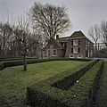
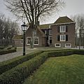
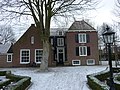
This is a category about rijksmonument number 37982
|
| Address |
|
Media in category "Boerhaavehuis, Voorhout"
The following 14 files are in this category, out of 14 total.
-
 Achtergevel - Voorhout - 20245795 - RCE.jpg 1,195 × 1,200; 494 KB
-
 Achterzijde - Voorhout - 20245796 - RCE.jpg 948 × 1,200; 315 KB
-
 Exterieur - Voorhout - 20245734 - RCE.jpg 1,200 × 886; 308 KB
-
 Gedeelte voorgevel - Voorhout - 20245792 - RCE.jpg 1,200 × 1,195; 420 KB
-
 Gedeelte voorgevel - Voorhout - 20245793 - RCE.jpg 1,200 × 1,200; 351 KB
-

-
 Nederlands Hervormde Pastorie, aanzicht - Voorhout - 20245790 - RCE.jpg 1,200 × 804; 253 KB
-
 Overzicht linker zijgevel met een gedeelte van de tuin - Voorhout - 20365857 - RCE.jpg 1,200 × 1,200; 397 KB
-
 Overzicht linker zijgevel met een gedeelte van de tuin - Voorhout - 20365858 - RCE.jpg 1,200 × 1,200; 406 KB
-
 Overzicht van tuin - Voorhout - 20365856 - RCE.jpg 1,200 × 1,200; 308 KB
-
 Tuin, reproductie naar foto Buiten - Voorhout - 20245732 - RCE.jpg 1,200 × 902; 406 KB
-
 Voorhout Boerhaavehuis.jpg 3,648 × 2,736; 6.12 MB
-
 Zijgevel - Voorhout - 20245794 - RCE.jpg 1,197 × 1,200; 429 KB
-
 Zijgevel, reproductie naar foto Buiten - Voorhout - 20245733 - RCE.jpg 1,200 × 846; 271 KB


