Category:Bohlenständerhaus Schrofen
| Object location | | View all coordinates using: OpenStreetMap |
|---|
building in Switzerland  | |||||
| Upload media | |||||
| Instance of | |||||
|---|---|---|---|---|---|
| Part of | |||||
| Location |
| ||||
| Street address |
| ||||
| Heritage designation |
| ||||
 | |||||
|
This is a category about a cultural property of national significance in Switzerland with KGS number 10150
|
Media in category "Bohlenständerhaus Schrofen"
The following 2 files are in this category, out of 2 total.
-
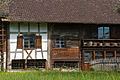 Amriswil-Schrofen-2.jpg 2,700 × 1,800; 4.3 MB
-
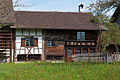 Amriswil-Schrofen.jpg 2,700 × 1,800; 4.93 MB
