Category:Bolivar Heights Battlefield
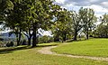
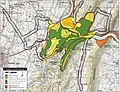
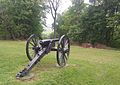
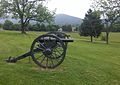
English: The Bolivar Heights Battlefield in Jefferson County, West Virginia, party in the town of Bolivar, is an American Civil War battlefield which was the site of five separate engagements between Union and Confederate troops, in October 1861, May and September 1862, June 1863, and July 1864. The battlefield lies primarily on the Bolivar Heights plateau, but also includes School House Ridge to the west, and the slopes of both, which meet at Bakerton Road. The site was also used by the armies as a campground, and, in 1864, as a Union corral and wagon yard. The battlefield is now part of the Harpers Ferry National Historical Park.
(Description source: National Park Service)
| Upload media | |||||
| Instance of | |||||
|---|---|---|---|---|---|
| Location |
| ||||
| Elevation above sea level |
| ||||
 | |||||
Media in category "Bolivar Heights Battlefield"
The following 13 files are in this category, out of 13 total.
-
 Bolivar Heights Battlefield, fence on Bakerton Road.jpg 4,032 × 3,024; 5.06 MB
-
 Bolivar Heights Battlefield, School House Ridge North fence on Bakerton Road.jpg 3,832 × 2,186; 3.02 MB
-
 Bolivar Heights cannon.png 624 × 468; 762 KB
-
 Bolivar Heights sign.png 740 × 555; 819 KB
-
 Bolivar Heights WV1.jpg 5,472 × 3,264; 19.53 MB
-
 Boom! Check out this color on Bolivar Heights (21791843254).jpg 809 × 1,079; 178 KB
-
 Cannon at Bolivar Heights Battlefield, WV IMG 4689.JPG 4,320 × 3,240; 4.5 MB
-
 Cannons (21117124212).jpg 1,080 × 1,080; 217 KB
-
 Harpers Ferry Battlefield West Virginia.jpg 1,610 × 1,240; 847 KB
-
 Harpers Ferry, gun on Bolivar Heights.jpg 1,420 × 1,000; 738 KB
-
 Harpers Ferry, union guns on Bolivar Heights.jpg 1,420 × 1,000; 662 KB
-
 NPS harpers-ferry-bolivar-heights-schoolhouse-ridge-trail-map.jpg 1,405 × 1,017; 318 KB
-


.jpg)

.jpg)


