Category:Bonifatiuskerk, Arnhem
| Object location | | View all coordinates using: OpenStreetMap |
|---|
church building in Arnhem, Netherlands  | |||||
| Upload media | |||||
| Instance of | |||||
|---|---|---|---|---|---|
| Location | Elden, Arnhem, Gelderland, Netherlands | ||||
| Street address |
| ||||
| Located on street |
| ||||
| Heritage designation |
| ||||
| Inception |
| ||||
 | |||||
Nederlands: Bonifatiuskerk (Elden) - anno 1866
|
This is a category about rijksmonument number 8385
|
| Address |
|
Media in category "Bonifatiuskerk, Arnhem"
The following 23 files are in this category, out of 23 total.
-
 Arnhem-Elden, Bonifaciuskerk foto11 2009-12-19 12.33.JPG 2,592 × 3,456; 949 KB
-
 Arnhem-Elden, Bonifaciuskerk foto6 2009-01-05 13.16.JPG 3,072 × 2,304; 4.05 MB
-
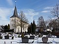 Arnhem-Elden, de Bonifatiuskerk RM8385 met sneeuw foto3 2017-01-15 12.32.jpg 4,269 × 3,202; 8.67 MB
-
 Avondmaalsschotel - Elden - 20069331 - RCE.jpg 1,200 × 938; 239 KB
-
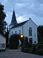
 Bonifatiuskerk (Elden).JPG 3,456 × 4,608; 3.17 MB
-
 Bonifatiuskerk te Elden.jpg 2,112 × 2,816; 3.27 MB
-
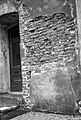 Detail - Elden - 20069333 - RCE.jpg 808 × 1,200; 255 KB
-
 Detail west-gevel toren - Elden - 20069341 - RCE.jpg 1,192 × 1,200; 412 KB
-
 Exterieur - Elden - 20069330 - RCE.jpg 950 × 1,200; 198 KB
-
 Exterieur - Elden - 20069332 - RCE.jpg 960 × 1,200; 218 KB
-

-
 Interieur naar de preekstoel - Elden - 20069342 - RCE.jpg 1,185 × 1,200; 219 KB
-
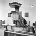
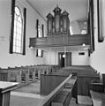 Interieur naar het orgel - Elden - 20069343 - RCE.jpg 1,190 × 1,200; 212 KB
-
 Noord gevel - Elden - 20069340 - RCE.jpg 1,190 × 1,200; 331 KB
-
 Oost-zijde - Elden - 20069335 - RCE.jpg 803 × 1,200; 182 KB
-
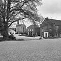 Overzicht met kerk en pastorie - Elden - 20069318 - RCE.jpg 1,197 × 1,200; 467 KB
-
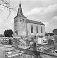 Overzicht vanuit het zuid-westen - Elden - 20069337 - RCE.jpg 1,181 × 1,200; 309 KB
-
 Preekstoel - Elden - 20069344 - RCE.jpg 1,197 × 1,200; 215 KB
-
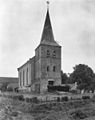 Toren - Elst - 20069726 - RCE.jpg 950 × 1,200; 191 KB
-
 Toren zuid-oost zijde - Elden - 20069334 - RCE.jpg 807 × 1,200; 131 KB
-
 Torenhaan - Elden - 20069336 - RCE.jpg 1,200 × 1,197; 106 KB
-
 Zuid-oost gevel - Elden - 20069338 - RCE.jpg 1,188 × 1,200; 402 KB
-
 Zuid-oost gevel - Elden - 20069339 - RCE.jpg 1,192 × 1,200; 421 KB


.JPG)


