Category:Boomstraat 64, Amsterdam
| Object location | | View all coordinates using: OpenStreetMap |
|---|
 | |||||
| Upload media | |||||
| Instance of |
| ||||
|---|---|---|---|---|---|
| Location | Amsterdam, North Holland, Netherlands | ||||
| Street address |
| ||||
| Located on street | |||||
| Heritage designation |
| ||||
 | |||||
|
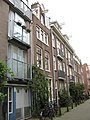
This is a category about rijksmonument number 680
|
| Address |
|
Media in category "Boomstraat 64, Amsterdam"
The following 3 files are in this category, out of 3 total.
-
 Amsterdam - Boomstraat 64.jpg 2,304 × 3,072; 2.55 MB
-
 Voorgevel - Amsterdam - 20016231 - RCE.jpg 1,186 × 1,200; 286 KB
-
 Voorgevels - Amsterdam - 20016229 - RCE.jpg 1,186 × 1,200; 311 KB

