Category:Boothstraat 6, Utrecht
| Object location | | View all coordinates using: OpenStreetMap |
|---|
house in Utrecht, Netherlands  | |||||
| Upload media | |||||
| Instance of | |||||
|---|---|---|---|---|---|
| Location | Utrecht, Netherlands | ||||
| Street address |
| ||||
| Heritage designation |
| ||||
 | |||||
|
This is a category about rijksmonument number 36024
|
| Address |
|
Media in category "Boothstraat 6, Utrecht"
The following 8 files are in this category, out of 8 total.
-
 Beets Papers LTK BEETS G 10, LTK BEETS G 10.pdf 1,239 × 1,752, 284 pages; 206.52 MB
-
 Boothstraat.6.Utrecht.jpg 4,000 × 3,000; 5.45 MB
-
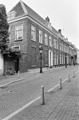 Exterieur OVERZICHT VOORGEVELS - Utrecht - 20314779 - RCE.jpg 788 × 1,200; 231 KB
-
 Exterieur OVERZICHT VOORGEVELS - Utrecht - 20314780 - RCE.jpg 1,200 × 956; 276 KB
-
 Exterieur VOORGEVEL - Utrecht - 20314781 - RCE.jpg 1,200 × 957; 274 KB
-
 Exterieur VOORGEVEL - Utrecht - 20314782 - RCE.jpg 788 × 1,200; 251 KB
-
 Exterieur VOORGEVELS - Utrecht - 20314778 - RCE.jpg 1,200 × 785; 256 KB
-
 Gedenksteen Beets.jpg 640 × 480; 89 KB


