Category:Borough Fen, Cambridgeshire
English: Borough Fen is a civil parish in the City of Peterborough unitary authority in Cambridgeshire, England.
civil parish in Cambridgeshire, United Kingdom | |||||
| Upload media | |||||
| Instance of | |||||
|---|---|---|---|---|---|
| Location | City of Peterborough, Cambridgeshire, East of England, England | ||||
 | |||||
Media in category "Borough Fen, Cambridgeshire"
The following 74 files are in this category, out of 74 total.
-
 A16 southbound - geograph.org.uk - 5697040.jpg 640 × 480; 28 KB
-
 A16 southbound - geograph.org.uk - 5697044.jpg 640 × 480; 32 KB
-
 Across the fields - geograph.org.uk - 2206117.jpg 640 × 480; 54 KB
-
 Ancient Willows - geograph.org.uk - 2206089.jpg 640 × 480; 102 KB
-
 Bend in the road - geograph.org.uk - 2193596.jpg 640 × 427; 54 KB
-
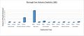 Borough Fen Employment Data (1881).jpg 879 × 378; 52 KB
-
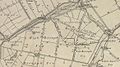 Borough Fen Map 1856.jpg 582 × 324; 100 KB
-
 Bull Bridge Farm - geograph.org.uk - 2198392.jpg 640 × 480; 84 KB
-
 Crowtree Farm near Newborough - geograph.org.uk - 2953475.jpg 4,320 × 3,240; 5.93 MB
-

-
 Eardley Grange - geograph.org.uk - 2198367.jpg 640 × 480; 65 KB
-
 Eardley Grange, Borough Fen - geograph.org.uk - 2345995.jpg 640 × 480; 79 KB
-
 Farm Shop and Pet Centre - geograph.org.uk - 2204893.jpg 640 × 480; 74 KB
-
 Farmland near Eardley Grange - geograph.org.uk - 3119045.jpg 640 × 480; 81 KB
-
 Farmland near Newborough - geograph.org.uk - 3119840.jpg 640 × 447; 80 KB
-
 Farmland near Slip Bridge - geograph.org.uk - 3118938.jpg 640 × 480; 77 KB
-
 Farmland off Decoy Road - geograph.org.uk - 3118925.jpg 640 × 480; 81 KB
-
 Farmland off Speechley's Drove - geograph.org.uk - 3119026.jpg 640 × 480; 73 KB
-
 Farmland off Speechley's Drove - geograph.org.uk - 3119039.jpg 640 × 480; 80 KB
-
 Farmland off Willow Drove - geograph.org.uk - 3119005.jpg 640 × 480; 73 KB
-
 Farmland off Willow Drove - geograph.org.uk - 3119008.jpg 640 × 480; 85 KB
-
 Farmland, Crowtree Farm - geograph.org.uk - 3119013.jpg 640 × 480; 82 KB
-
 Farmland, Flood Farm - geograph.org.uk - 3142623.jpg 640 × 480; 56 KB
-
 Farmland, Newborough - geograph.org.uk - 3118946.jpg 640 × 480; 88 KB
-
 Fenland drain off Bukehorn Road near Eye - geograph.org.uk - 2894144.jpg 4,320 × 3,240; 5.14 MB
-
 Fenland farmland near Eye Green - geograph.org.uk - 1444938.jpg 640 × 480; 52 KB
-
 Flat farmland off Peterborough Road - geograph.org.uk - 4412893.jpg 640 × 480; 72 KB
-
 Grain silos at Moor's Farm - geograph.org.uk - 2894204.jpg 4,320 × 3,240; 5.39 MB
-
 Harvesting off Speechleys Drove (geograph 3119022).jpg 640 × 481; 90 KB
-
 Highland Drain - geograph.org.uk - 5265323.jpg 800 × 450; 209 KB
-
 Horseshoe Bridge on Peterborough Road - geograph.org.uk - 2894211.jpg 4,320 × 3,240; 5.84 MB
-
 Houses at Baxter's Bridge - geograph.org.uk - 2198372.jpg 640 × 480; 60 KB
-
 Looking north along Willow Drove near Newborough - geograph.org.uk - 3011527.jpg 4,320 × 3,240; 5.59 MB
-
 Lower Willow Farm - geograph.org.uk - 2198387.jpg 640 × 480; 111 KB
-
 Middle Drain - geograph.org.uk - 998489.jpg 640 × 480; 58 KB
-
 Moor's Farm - geograph.org.uk - 2306990.jpg 640 × 480; 58 KB
-
 Moor's Farm - geograph.org.uk - 4412889.jpg 640 × 475; 33 KB
-
 Moor's Farm - geograph.org.uk - 5265328.jpg 800 × 450; 202 KB
-
 Moore's Farm on Decoy Road, Newborough - geograph.org.uk - 3793636.jpg 4,320 × 3,240; 5.43 MB
-
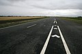
 New A16 (A1073) - geograph.org.uk - 2188008.jpg 640 × 427; 58 KB
-
 North Level - geograph.org.uk - 5265326.jpg 800 × 450; 200 KB
-
 Northbound Crowland Road (A1073) - geograph.org.uk - 3142625.jpg 640 × 480; 57 KB
-
 Peterborough Road - without a windscreen - geograph.org.uk - 5265327.jpg 800 × 450; 158 KB
-
 Peterborough Road, North Level - geograph.org.uk - 5265331.jpg 800 × 450; 190 KB
-
 Pill Box - geograph.org.uk - 2206869.jpg 640 × 480; 104 KB
-

-

-
 Pillbox near Pank's Farm - geograph.org.uk - 3119056.jpg 640 × 480; 113 KB
-
 Pillbox off Speechley's Drove - geograph.org.uk - 3119029.jpg 640 × 399; 67 KB
-
 Pillbox on Speechley's Drove at the end of The Avenue - geograph.org.uk - 3012621.jpg 4,320 × 3,240; 5.52 MB
-
 Pillbox on Speechley's Drove near Pank's Farm - geograph.org.uk - 3012690.jpg 4,320 × 3,240; 5.43 MB
-
 Pillbox on Speechley's Drove south of Eardley Grange - geograph.org.uk - 3012610.jpg 4,320 × 3,240; 5.9 MB
-
-
 Redcow Drain - geograph.org.uk - 3118927.jpg 640 × 480; 114 KB
-
 Roadside ditch and the new A16 near Newborough - geograph.org.uk - 2953492.jpg 4,320 × 3,240; 5.6 MB
-
 Speechley Drove - geograph.org.uk - 1444933.jpg 640 × 480; 43 KB
-
 Speechley's Drove - geograph.org.uk - 2346126.jpg 480 × 640; 65 KB
-
 Speechley's Drove and Pank's Farm - geograph.org.uk - 2346491.jpg 640 × 473; 60 KB
-
 Speechley's Drove heading north - geograph.org.uk - 3119024.jpg 640 × 480; 78 KB
-
 Speechley's Drove heading north - geograph.org.uk - 3119027.jpg 640 × 480; 67 KB
-
 Speechley's Drove heading north - geograph.org.uk - 3119034.jpg 640 × 480; 120 KB
-

-

-
 The lane without a name north of Newborough - geograph.org.uk - 3012470.jpg 4,320 × 3,240; 5.58 MB
-
 Track near Olympia Farm - geograph.org.uk - 2894194.jpg 4,320 × 3,240; 5.34 MB
-
 Track to Pepperlake Farm - geograph.org.uk - 4412892.jpg 640 × 480; 48 KB
-
 Tracks in the wheat - geograph.org.uk - 3012585.jpg 4,320 × 3,240; 5.63 MB
-
 Willow Drove - geograph.org.uk - 2203804.jpg 640 × 480; 72 KB
-
 Willow Drove - geograph.org.uk - 2204991.jpg 640 × 480; 85 KB
-
 Willow Drove - geograph.org.uk - 998517.jpg 640 × 480; 73 KB
-
 Willow Drove heading north - geograph.org.uk - 3119007.jpg 640 × 480; 92 KB
-
 Willow Drove heading north - geograph.org.uk - 3119011.jpg 640 × 480; 84 KB
-
 Willow Drove near Willow Barn Farm - geograph.org.uk - 3011544.jpg 4,320 × 3,240; 6.02 MB
-
 Willow Drove, Newborough - geograph.org.uk - 3011503.jpg 4,320 × 3,240; 5.81 MB


.jpg)


.jpg)


_-_geograph.org.uk_-_2188008.jpg)

_-_geograph.org.uk_-_3142625.jpg)


