Category:Bowscale Fell
English: Bowscale Fell is a hill in the civil parish of Mungrisdale, in the Eden district, in the county of Cumbria, England.
mountain in United Kingdom  | |||||
| Upload media | |||||
| Instance of | |||||
|---|---|---|---|---|---|
| Location | Cumbria, North West England, England | ||||
| Mountain range | |||||
| Elevation above sea level |
| ||||
| Parent peak | |||||
 | |||||
Media in category "Bowscale Fell"
The following 14 files are in this category, out of 14 total.
-
 Bowscale Fell - geograph.org.uk - 2634332.jpg 3,872 × 2,592; 4.82 MB
-
 Bowscale Fell - geograph.org.uk - 639802.jpg 640 × 480; 125 KB
-
 Bowscale Fell - geograph.org.uk - 639805.jpg 640 × 480; 127 KB
-
 Bowscale Fell - geograph.org.uk - 639808.jpg 640 × 480; 125 KB
-
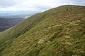
 Bowscale Fell from the north-east - geograph.org.uk - 1835843.jpg 2,048 × 1,536; 1.14 MB
-
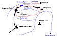 Bowscale Fell sketch map.JPG 512 × 384; 23 KB
-
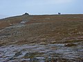
 Bowscale Fell Summit - geograph.org.uk - 2214435.jpg 640 × 480; 92 KB
-
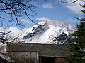 Bowscale Fell.JPG 3,264 × 2,448; 2.24 MB
-
 Looking East from Bowscale Fell - geograph.org.uk - 31101.jpg 600 × 180; 60 KB
-
 Near the summit of Bowscale Fell - geograph.org.uk - 18984.jpg 640 × 425; 33 KB
-
 North ridge of Bowscale Fell - geograph.org.uk - 639796.jpg 640 × 480; 129 KB
-
 Southern slopes of Bowscale Fell - geograph.org.uk - 639807.jpg 640 × 480; 138 KB
-
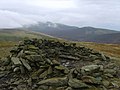
 Summit Cairn, Bowscale Fell - geograph.org.uk - 653053.jpg 640 × 480; 64 KB
-
 Wind Shelter Bowscale Fell - geograph.org.uk - 1028037.jpg 640 × 480; 69 KB


