Category:Boylestone
village and civil parish in Derbyshire Dales district, Derbyshire, England  | |||||
| Upload media | |||||
| Instance of | |||||
|---|---|---|---|---|---|
| Location | Derbyshire Dales, Derbyshire, East Midlands, England | ||||
 | |||||
Subcategories
This category has the following 3 subcategories, out of 3 total.
Media in category "Boylestone"
The following 50 files are in this category, out of 50 total.
-
 Audishaw Lane - geograph.org.uk - 4914623.jpg 640 × 480; 91 KB
-
 Audishaw Lane in Boylestone - geograph.org.uk - 4137074.jpg 4,000 × 3,000; 2.94 MB
-
 Bend in unnamed lane - geograph.org.uk - 3708932.jpg 2,256 × 1,504; 2.57 MB
-
 Bike on a Lane - geograph.org.uk - 368620.jpg 640 × 480; 86 KB
-
 Bourne Methodist Church, Boylestone - geograph.org.uk - 4670018.jpg 640 × 481; 465 KB
-
 Boylesetone Village Hall - geograph.org.uk - 4914636.jpg 640 × 480; 121 KB
-
 Boylestone Methodist Church - geograph.org.uk - 4670012.jpg 640 × 481; 522 KB
-

-
 Boylestone, Chapel Lane - geograph.org.uk - 4670025.jpg 640 × 481; 495 KB
-
 Boylestone, Muse lane - geograph.org.uk - 4670033.jpg 640 × 480; 393 KB
-
 Brook Farm - Boylestone - geograph.org.uk - 1450341.jpg 640 × 425; 97 KB
-
 Brook, Boylestone - geograph.org.uk - 4914640.jpg 640 × 480; 133 KB
-
 Cherry Pie Cottage - geograph.org.uk - 4914626.jpg 640 × 480; 92 KB
-
 Church and Grazing Land at Boylestone - geograph.org.uk - 4137083.jpg 4,000 × 3,000; 3.16 MB
-
 Close up, Elizabeth II postbox on New Road - geograph.org.uk - 4914655.jpg 1,198 × 2,472; 542 KB
-
 Cottages, The Square, Boylestone - geograph.org.uk - 4913596.jpg 640 × 480; 66 KB
-
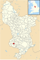 Derbyshire UK parish map highlighting Boylestone.svg 888 × 1,308; 2.34 MB
-

-
 Field of Stubble near Old Myers - geograph.org.uk - 4137096.jpg 4,000 × 3,000; 3.33 MB
-
 Fields near Boylestone - geograph.org.uk - 4210545.jpg 4,000 × 3,000; 2.41 MB
-
 Ford at Boylestone - geograph.org.uk - 3422604.jpg 3,872 × 2,592; 2.36 MB
-

-
 Gated entrance to Cottage Farm - geograph.org.uk - 4914618.jpg 640 × 480; 78 KB
-

-
 Grazing near New Top Farm - geograph.org.uk - 4914614.jpg 640 × 480; 57 KB
-
 House on Audishaw Lane - geograph.org.uk - 5672071.jpg 2,000 × 1,333; 1.87 MB
-
 House on New Road - geograph.org.uk - 4915084.jpg 640 × 480; 64 KB
-
 Junction of New Road and Muse Lane at Boylestone - geograph.org.uk - 3769192.jpg 2,137 × 1,425; 3.62 MB
-
 Large house, The Square, Boylesetone - geograph.org.uk - 4914631.jpg 640 × 480; 64 KB
-
 Minor road near New Top Farm - geograph.org.uk - 4914616.jpg 640 × 480; 66 KB
-
 New Road - geograph.org.uk - 4914656.jpg 3,488 × 2,528; 1.04 MB
-
 New Road approaching Boylestone - geograph.org.uk - 4670043.jpg 640 × 480; 476 KB
-
 New Road near Harehill Park Farm - geograph.org.uk - 4670039.jpg 640 × 480; 493 KB
-
 New Road towards the Rose and Crown Pub - geograph.org.uk - 3707133.jpg 2,256 × 1,504; 2.12 MB
-
 New Road, Boylestone - geograph.org.uk - 4669996.jpg 640 × 480; 466 KB
-
 New Road, Boylestone - geograph.org.uk - 4915086.jpg 640 × 480; 67 KB
-
 Outbuildings, Cherry Pie Cottage - geograph.org.uk - 4914620.jpg 640 × 480; 90 KB
-
 Public House at Boylestone - Detail - geograph.org.uk - 4136175.jpg 2,070 × 1,167; 816 KB
-
 Pump at Younds Cottage Farm - geograph.org.uk - 5683778.jpg 1,071 × 1,600; 968 KB
-
 Road Junction near Sudbury Coppice - geograph.org.uk - 4277947.jpg 4,000 × 3,000; 3.2 MB
-
 Road to High Grounds Farm - geograph.org.uk - 3707031.jpg 2,256 × 1,504; 2.05 MB
-

-
 Sheep shall safely graze - geograph.org.uk - 5672065.jpg 2,000 × 1,333; 2.21 MB
-
 Show Day in Boylestone - geograph.org.uk - 4136203.jpg 3,767 × 2,621; 4.28 MB
-

-
 The Rose and Crown, Boylestone - geograph.org.uk - 4914643.jpg 640 × 480; 55 KB
-
 The Square, Boylesetone - geograph.org.uk - 4914633.jpg 640 × 480; 125 KB
-
 Twisses Bank near Boylestone - geograph.org.uk - 4136090.jpg 3,938 × 2,916; 3.31 MB
-
 Victorian postbox on The Square, Boylestone - geograph.org.uk - 4913594.jpg 1,444 × 2,645; 795 KB
-
 Winding Lane from Boylestone - geograph.org.uk - 368645.jpg 640 × 480; 111 KB


_-_geograph.org.uk_-_4670023.jpg)


