Category:Brayford
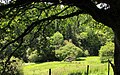
English: Brayford is a village in Devon, England. Situated near about 5 miles from South Molton and 6 miles from Barnstaple. Brayford is a small village on Exmoor and sits beneath open areas of common land. It is a small rural community and in the surrounding area are many farms.
village and civil parish in Devon, UK  | |||||
| Upload media | |||||
| Instance of |
| ||||
|---|---|---|---|---|---|
| Location | North Devon, Devon, South West England, England | ||||
 | |||||
Subcategories
This category has the following 2 subcategories, out of 2 total.
C
H
Media in category "Brayford"
The following 200 files are in this category, out of 241 total.
(previous page) (next page)-
 A boundary marker on Leworthy Bridge on the river Bray - geograph.org.uk - 3916317.jpg 3,648 × 2,736; 4.8 MB
-
 A plaque on the upstream wall of Brayford Bridge - geograph.org.uk - 3916156.jpg 3,558 × 2,668; 4.27 MB
-
 A tiger in a tree at Leworthy Bridge - geograph.org.uk - 3904670.jpg 3,648 × 2,736; 4.07 MB
-
 A399 bend in woodland north of Brayford - geograph.org.uk - 5686525.jpg 1,600 × 1,281; 985 KB
-
 A399 following the south side of the valley to Brayford - geograph.org.uk - 4726289.jpg 1,600 × 1,600; 1.71 MB
-
 A399 on north slope of Mockham Down - geograph.org.uk - 5686534.jpg 1,600 × 1,280; 900 KB
-
 A399 passing Bray Valley Quarries - geograph.org.uk - 5889090.jpg 2,204 × 1,656; 1.46 MB
-
 A399 south of Bray Valley Quarries - geograph.org.uk - 5686495.jpg 1,600 × 1,201; 854 KB
-
 Access road to Natsley - geograph.org.uk - 4108297.jpg 640 × 480; 108 KB
-
 Access road to Rockley Farm - geograph.org.uk - 6111384.jpg 1,600 × 1,458; 1.28 MB
-
 Approaching Bray Valley Quarries on the A399 - geograph.org.uk - 5989754.jpg 1,024 × 765; 209 KB
-
 Barn and road north-west at Brayford Hill - geograph.org.uk - 5686519.jpg 1,600 × 1,143; 903 KB
-
 Barn east of Leworthy Bridge - geograph.org.uk - 6111361.jpg 1,600 × 1,069; 751 KB
-
 Barn, Fullaford - geograph.org.uk - 731333.jpg 640 × 426; 106 KB
-
 Barns and trees at Fullaford - geograph.org.uk - 6111364.jpg 1,600 × 914; 662 KB
-
 Beech tree on Mill Lane - geograph.org.uk - 5988382.jpg 1,024 × 768; 320 KB
-
 Bend in the road near The Sloley Stone - geograph.org.uk - 2084419.jpg 800 × 633; 137 KB
-
 Bicycle and hikers pit stop^ - geograph.org.uk - 5988954.jpg 768 × 1,024; 222 KB
-
 Blakewell Hill - geograph.org.uk - 5988848.jpg 1,024 × 768; 305 KB
-
 Boundary wall near Comerslade - geograph.org.uk - 5140069.jpg 1,024 × 768; 175 KB
-
 Bray Common - geograph.org.uk - 3670873.jpg 1,024 × 768; 226 KB
-
 Bray Valley Quarries - geograph.org.uk - 5686498.jpg 1,600 × 1,067; 520 KB
-
 Bray Valley Quarry - geograph.org.uk - 5989733.jpg 1,024 × 769; 171 KB
-
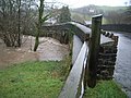
 Brayford Bridge - geograph.org.uk - 4727608.jpg 1,600 × 1,201; 1.33 MB
-
 Brayford Bridge on the river Bray at Brayford - geograph.org.uk - 3916148.jpg 3,648 × 2,736; 5.35 MB
-
 Brayford Bridge on the river Bray at Brayford - geograph.org.uk - 3916149.jpg 3,648 × 2,736; 4.61 MB
-

-
 Brayford Methodist Church - geograph.org.uk - 2668712.jpg 1,024 × 768; 280 KB
-
 Brayford Methodist Church - geograph.org.uk - 3702478.jpg 4,000 × 3,000; 2.84 MB
-
 Brayford Methodist Church - geograph.org.uk - 4727607.jpg 1,600 × 1,200; 1.36 MB
-
 Brayford Methodist Church - geograph.org.uk - 4831706.jpg 1,024 × 768; 179 KB
-
 Brayford Village Hall - geograph.org.uk - 4727844.jpg 1,600 × 1,200; 1.46 MB
-
 Brayford, Brayford quarry - geograph.org.uk - 533267.jpg 640 × 427; 175 KB
-
 Brayford, Charlestown Barton Wood - geograph.org.uk - 533264.jpg 640 × 427; 275 KB
-
 Brayford, millpond at Hudley Mill - geograph.org.uk - 91288.jpg 640 × 440; 184 KB
-
 Brayford, Rockley Farm - geograph.org.uk - 222270.jpg 640 × 435; 109 KB
-

-

-
 Brockenbarrow Group.jpg 1,200 × 720; 216 KB
-
 Cattle grid and Driveway, Winsley - geograph.org.uk - 5548227.jpg 1,024 × 768; 235 KB
-
 Chapel in the village of Brayford - geograph.org.uk - 173289.jpg 640 × 480; 126 KB
-
 Charles Bottom - geograph.org.uk - 71778.jpg 480 × 640; 55 KB
-
 Charles Cross - geograph.org.uk - 5988940.jpg 1,024 × 759; 170 KB
-
 Charles, farmland near Thornpark Cross - geograph.org.uk - 519997.jpg 640 × 427; 197 KB
-
 Charles, Higher Welcombe Cross - geograph.org.uk - 520004.jpg 640 × 427; 237 KB
-
 Charles, over a hedge - geograph.org.uk - 520001.jpg 640 × 427; 326 KB
-
 Charles, towards Brayford - geograph.org.uk - 520000.jpg 640 × 427; 182 KB
-
 Combe Bank Cottage, Holewater Hill - geograph.org.uk - 629775.jpg 640 × 480; 81 KB
-
 Cottage on Mill Lane - geograph.org.uk - 5988378.jpg 1,024 × 763; 143 KB
-
 Cross Gate - geograph.org.uk - 4108252.jpg 640 × 480; 103 KB
-
 Cross Gate - geograph.org.uk - 5547879.jpg 1,024 × 768; 201 KB
-
 Cycle track at Mockham Down Gate - geograph.org.uk - 4726285.jpg 1,600 × 1,200; 1.11 MB
-
 Descending from Black Hill - geograph.org.uk - 3672275.jpg 1,024 × 768; 234 KB
-
 East Down Wood - geograph.org.uk - 5547915.jpg 1,024 × 768; 213 KB
-
 East side of Shoulsbury Castle - geograph.org.uk - 3672413.jpg 1,024 × 768; 249 KB
-
 Entrance Drive, Little Bray House - geograph.org.uk - 4831703.jpg 1,024 × 676; 218 KB
-
 Entrance to Brayford - geograph.org.uk - 3287266.jpg 640 × 480; 105 KB
-
 Entrance, Higher Hall Farm - geograph.org.uk - 4831722.jpg 1,024 × 837; 190 KB
-
 Exmoor National Park boundary near Brayford - geograph.org.uk - 4727845.jpg 1,600 × 1,200; 1.43 MB
-
 Exmoor patchwork - geograph.org.uk - 621918.jpg 640 × 480; 70 KB
-
 Farm buildings at Fullaford - geograph.org.uk - 5774662.jpg 1,024 × 737; 148 KB
-
 Farm track on Blakewell Hill - geograph.org.uk - 5988846.jpg 1,024 × 768; 233 KB
-
 Field - geograph.org.uk - 4108279.jpg 640 × 480; 66 KB
-
 Field entrance off the road east of Higher Mockham - geograph.org.uk - 6111318.jpg 1,600 × 1,140; 550 KB
-
 Field of sheep at Mockham Down Gate - geograph.org.uk - 4726287.jpg 1,600 × 1,200; 1.25 MB
-
 Fingerpost - geograph.org.uk - 4108267.jpg 640 × 480; 75 KB
-
 Five Cross Way - geograph.org.uk - 3672457.jpg 1,024 × 768; 239 KB
-
 Five Cross Way - geograph.org.uk - 4108303.jpg 640 × 480; 54 KB
-
 Five Cross Way - geograph.org.uk - 4108306.jpg 640 × 480; 90 KB
-
 Five Cross Way - geograph.org.uk - 4108308.jpg 640 × 480; 88 KB
-
 Five Cross Way - geograph.org.uk - 4108309.jpg 640 × 480; 103 KB
-
 Five Cross Way - geograph.org.uk - 4108313.jpg 640 × 480; 103 KB
-
 Five Cross Way - geograph.org.uk - 4108316.jpg 640 × 480; 81 KB
-
 Five Cross Way, road to Fullaford Down - geograph.org.uk - 6111378.jpg 1,600 × 1,200; 1.05 MB
-
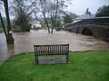 Flooding at Brayford bridge - geograph.org.uk - 629789.jpg 640 × 480; 86 KB
-
 Footpath running north from Holewater Hill - geograph.org.uk - 4727847.jpg 1,600 × 1,067; 1.29 MB
-
 Ford in Holewater Woods - geograph.org.uk - 4193850.jpg 3,872 × 2,592; 5.39 MB
-
 Ford in Kedworthy Combe - geograph.org.uk - 5548507.jpg 1,024 × 768; 363 KB
-
 Former farmhouse, West Blakewell (geograph 6435519).jpg 3,113 × 1,760; 998 KB
-
 Former toll house, Newtown - geograph.org.uk - 5988995.jpg 1,024 × 768; 223 KB
-
 Fullaford - geograph.org.uk - 4108332.jpg 640 × 480; 101 KB
-
 Gallop at Higher Shutscombe - geograph.org.uk - 6207753.jpg 1,024 × 768; 217 KB
-
 Gate and footpath, on Bray Common - geograph.org.uk - 3672208.jpg 1,024 × 768; 261 KB
-
 Gateway above Kedworthy Combe - geograph.org.uk - 5548497.jpg 1,024 × 768; 281 KB
-
 Glebe Farmhouse - geograph.org.uk - 6207776.jpg 1,024 × 795; 197 KB
-
 Grazing sheep - geograph.org.uk - 5548558.jpg 1,024 × 768; 215 KB
-
 Green Lane on Fullaford Down - geograph.org.uk - 3672828.jpg 1,024 × 768; 232 KB
-
 Hedges and hedgebanks on Castle Common - geograph.org.uk - 6113876.jpg 1,600 × 1,065; 751 KB
-
 Henthitchen Combe - geograph.org.uk - 3672260.jpg 1,024 × 784; 275 KB
-
 High Bray, above Lydcott - geograph.org.uk - 271719.jpg 640 × 427; 154 KB
-
 High Bray, above Sherracombe Ford - geograph.org.uk - 266449.jpg 640 × 427; 190 KB
-
 High Bray, Bray Common - geograph.org.uk - 271709.jpg 640 × 427; 194 KB
-
 High Bray, by Bray Cross - geograph.org.uk - 519994.jpg 640 × 427; 212 KB
-
 High Bray, near Five Cross Way - geograph.org.uk - 271718.jpg 640 × 427; 142 KB
-
 High Bray, on Fullaford Down - geograph.org.uk - 271717.jpg 640 × 427; 217 KB
-
 High Bray, towards Castle Common - geograph.org.uk - 271710.jpg 640 × 427; 165 KB
-
 High Bray, towards Sherracombe Ford - geograph.org.uk - 266450.jpg 640 × 427; 186 KB
-
 Hillside above East Down Wood - geograph.org.uk - 5548281.jpg 1,024 × 768; 174 KB
-
 Holewater Bridge - geograph.org.uk - 4727849.jpg 1,600 × 1,278; 1.56 MB
-
 Holewater Cross - geograph.org.uk - 4831726.jpg 1,024 × 768; 205 KB
-
 Holewater Valley - geograph.org.uk - 5547900.jpg 1,024 × 768; 252 KB
-
 House at Charles Bottom Cross - geograph.org.uk - 5988368.jpg 1,024 × 768; 134 KB
-
 House at Fullaford - geograph.org.uk - 5774670.jpg 1,024 × 790; 140 KB
-
 House at Higher Mockham - geograph.org.uk - 6153671.jpg 1,024 × 752; 221 KB
-
 House at South Whitefield Farm - geograph.org.uk - 5548248.jpg 1,024 × 768; 208 KB
-
 Houses and the Methodist Church in Brayford - geograph.org.uk - 4727605.jpg 1,600 × 1,198; 1.46 MB
-
 Hudley Mill - geograph.org.uk - 6207810.jpg 1,024 × 768; 210 KB
-
 Hudley Mill Bridge - geograph.org.uk - 6207796.jpg 1,024 × 768; 281 KB
-
 Hudley Mill Hill - geograph.org.uk - 6199548.jpg 3,219 × 2,452; 1.39 MB
-

-
 Kedworthy Combe - geograph.org.uk - 5548493.jpg 1,024 × 768; 173 KB
-
 Kedworthy Down - geograph.org.uk - 731306.jpg 640 × 351; 59 KB
-
 Leworthy Bridge on the river Bray - geograph.org.uk - 3916297.jpg 3,648 × 2,736; 5.55 MB
-
 Leworthy Bridge on the river Bray - geograph.org.uk - 3916302.jpg 3,648 × 2,736; 4.75 MB
-
 Looking along Holewater Hill - geograph.org.uk - 629776.jpg 640 × 480; 65 KB
-

-
 Looking down the river Bray from Brayford Bridge - geograph.org.uk - 3916151.jpg 3,648 × 2,736; 4.41 MB
-
 Looking down the river Bray from Leworthy Bridge - geograph.org.uk - 3916306.jpg 3,648 × 2,736; 5.02 MB
-

-
 Looking south east from Setta Barrow - geograph.org.uk - 5139822.jpg 1,024 × 768; 193 KB
-
 Looking towards Brayford - geograph.org.uk - 629772.jpg 640 × 480; 72 KB
-
 Looking towards East Down Wood - geograph.org.uk - 629766.jpg 640 × 480; 102 KB
-
 Looking towards Little Bray - geograph.org.uk - 629812.jpg 640 × 480; 73 KB
-
 Looking towards Stock Down - geograph.org.uk - 629805.jpg 640 × 480; 100 KB
-
 Looking up the river Bray from Brayford Bridge - geograph.org.uk - 3916154.jpg 3,648 × 2,736; 5.06 MB
-
 Looking up the river Bray from Leworthy Bridge - geograph.org.uk - 3916319.jpg 3,648 × 2,736; 4.21 MB
-

-
 Looking up the river Bray from Newtown Bridge on the A399 - geograph.org.uk - 3916142.jpg 3,648 × 2,736; 4.53 MB
-

-
 Lydcott near High Bray - geograph.org.uk - 1071832.jpg 640 × 480; 111 KB
-
 Mill Lane, Brayford - geograph.org.uk - 4831713.jpg 1,024 × 799; 195 KB
-
 Minor road above Little Melcombe - geograph.org.uk - 3672220.jpg 1,024 × 768; 289 KB
-
 Minor road on Fullaford Down - geograph.org.uk - 3672449.jpg 1,024 × 768; 204 KB
-
 Minor road on Stock Down - geograph.org.uk - 4831688.jpg 1,024 × 768; 308 KB
-
 Minor road to Challacombe - geograph.org.uk - 5548254.jpg 1,024 × 846; 257 KB
-
 Minor road to Thornpark Cross - geograph.org.uk - 6207763.jpg 1,024 × 768; 258 KB
-
 Mockham Down Gate - geograph.org.uk - 6180535.jpg 1,024 × 758; 177 KB
-
 Moorland gateway - geograph.org.uk - 5140076.jpg 1,024 × 815; 225 KB
-
 Muxworthy Farm Road - geograph.org.uk - 629768.jpg 640 × 480; 127 KB
-
 Muxworthy Lane - geograph.org.uk - 4108274.jpg 640 × 480; 104 KB
-
 Muxworthy Lane - geograph.org.uk - 5548265.jpg 1,024 × 743; 188 KB
-
 Muxworthy Lane - geograph.org.uk - 5548293.jpg 1,024 × 768; 339 KB
-
 New outbuildings at Little Bray Farm - geograph.org.uk - 4831696.jpg 1,024 × 823; 186 KB
-
 North Devon , Sunny Bank - geograph.org.uk - 5684056.jpg 6,000 × 4,000; 7.76 MB
-

-

-
 Ordnance Survey Cut Mark - geograph.org.uk - 3724676.jpg 4,000 × 3,000; 3.59 MB
-
 Ordnance Survey Cut Mark - geograph.org.uk - 3859916.jpg 480 × 640; 98 KB
-
 Ordnance Survey Cut Mark - geograph.org.uk - 4451012.jpg 640 × 480; 122 KB
-
 Ordnance Survey Cut Mark - geograph.org.uk - 4451036.jpg 480 × 640; 114 KB
-
 Ordnance Survey Cut Mark - geograph.org.uk - 5026053.jpg 577 × 640; 147 KB
-
 Ordnance Survey Flush Bracket (S2813) - geograph.org.uk - 4451029.jpg 480 × 640; 128 KB
-

-
 Ordnance Survey Flush Bracket S2812 - geograph.org.uk - 4740101.jpg 4,000 × 3,000; 4.1 MB
-
 Ordnance Survey Flush Bracket S2813 - geograph.org.uk - 3724655.jpg 4,000 × 3,000; 4.33 MB
-
 Orstone Cross - geograph.org.uk - 5988853.jpg 1,024 × 751; 196 KB
-
 Path in Kedworthy Combe - geograph.org.uk - 5548501.jpg 1,024 × 768; 211 KB
-
 Pond, above Whitefield Farm - geograph.org.uk - 5548239.jpg 1,024 × 763; 180 KB
-
 Quarry in the Bray valley - geograph.org.uk - 1709459.jpg 640 × 480; 92 KB
-
 River Bray from Newtown Bridge - geograph.org.uk - 5989002.jpg 1,024 × 768; 313 KB
-
 River Bray, glimpsed through woodland - geograph.org.uk - 5989741.jpg 1,024 × 768; 343 KB
-
 Road across Fullaford Down - geograph.org.uk - 4108324.jpg 640 × 480; 91 KB
-
 Road east of Fullaford - geograph.org.uk - 6111369.jpg 1,600 × 1,200; 668 KB
-
 Road junction - geograph.org.uk - 4108255.jpg 640 × 480; 80 KB
-
 Road north of Thornpark Cross - geograph.org.uk - 6109896.jpg 1,600 × 1,068; 804 KB
-
 Road on Castle Common - geograph.org.uk - 6113877.jpg 1,600 × 1,200; 740 KB
-
 Road on North Hill and Henthitchen - geograph.org.uk - 6113880.jpg 1,600 × 1,144; 692 KB
-
 Road on reclaimed marshland on Great Melcombe - geograph.org.uk - 6113881.jpg 1,600 × 1,066; 669 KB
-
 Road to Barton Town - geograph.org.uk - 3672844.jpg 1,024 × 768; 240 KB
-
 Road to Wallover Barton - geograph.org.uk - 5774665.jpg 1,024 × 801; 200 KB
-
 Road with hedgebanks on Fullaford Down - geograph.org.uk - 6111380.jpg 1,600 × 1,202; 1.03 MB
-
 Roadside seat, Little Melcombe - geograph.org.uk - 3670912.jpg 1,024 × 768; 283 KB
-
 Rockhead Hill crossing the river Bray at Newtown Bridge - geograph.org.uk - 3916143.jpg 6,000 × 4,000; 5.6 MB
-
 Rockhead Hill crossing the river Bray at Newtown Bridge - geograph.org.uk - 3916144.jpg 6,000 × 4,000; 4.55 MB
-
 Rockley Lane - geograph.org.uk - 3672455.jpg 1,024 × 768; 264 KB
-
 Rocks Head Cross - geograph.org.uk - 5989007.jpg 1,024 × 824; 178 KB
-
 Rough grass on Castle Common - geograph.org.uk - 3672422.jpg 1,024 × 768; 241 KB
-
 Rough grazing near Henthitchen Combe - geograph.org.uk - 621900.jpg 640 × 335; 53 KB
-
 Ruby red Devon cattle, North Twitchen - geograph.org.uk - 3670842.jpg 1,024 × 768; 196 KB
-
 Ruin, Charles Bottom - geograph.org.uk - 6199533.jpg 2,903 × 1,803; 1.2 MB
-
 Setta Barrow - geograph.org.uk - 5139807.jpg 1,024 × 800; 200 KB
-
 Sheep on Castle Common - geograph.org.uk - 3672314.jpg 1,024 × 768; 187 KB
-
 Sheep on Castle Common - geograph.org.uk - 3672375.jpg 1,024 × 747; 192 KB
-
 Sheepfold on Castle Common - geograph.org.uk - 3672444.jpg 1,024 × 768; 218 KB
-
 Shepherd's hut, North Twitchen - geograph.org.uk - 3670705.jpg 1,024 × 768; 192 KB
-
 Sign for Tarka Trail and Macmillan Way West - geograph.org.uk - 6113884.jpg 1,600 × 800; 494 KB
-
 Sloley Stone - geograph.org.uk - 3859925.jpg 480 × 640; 86 KB
-
 South side of Shoulsbury Castle - geograph.org.uk - 3672410.jpg 1,024 × 738; 258 KB
-
 St John the Baptist's Church - geograph.org.uk - 4451020.jpg 640 × 480; 89 KB
-
 St Petroc - geograph.org.uk - 6207788.jpg 1,024 × 768; 270 KB
-
 Straight road on Fullaford Down - geograph.org.uk - 6111381.jpg 1,600 × 1,281; 1.12 MB
-
 Stream at Fullaford - geograph.org.uk - 621936.jpg 640 × 480; 130 KB
-
 Surging water under Brayford bridge - geograph.org.uk - 629800.jpg 640 × 480; 97 KB
-
 Telecoms mast on Blakewell Hill - geograph.org.uk - 5988852.jpg 1,024 × 785; 225 KB
-
 Telephone Box, Brayford - geograph.org.uk - 4108244.jpg 640 × 480; 78 KB
-
 The A399 at Newtown Bridge on the river Bray - geograph.org.uk - 3916135.jpg 3,648 × 2,736; 5.47 MB
-
 The A399 at Newtown Bridge on the river Bray - geograph.org.uk - 3916137.jpg 3,648 × 2,736; 5.36 MB
-
 The church of St John the Baptist, Charles - geograph.org.uk - 5988943.jpg 1,024 × 768; 187 KB
-
 The church of St John the Baptist, Charles - geograph.org.uk - 5988946.jpg 1,024 × 768; 143 KB
-
 The downstream side of Brayford Bridge on the river Bray - geograph.org.uk - 3916152.jpg 3,648 × 2,736; 5.27 MB


.jpg)


_-_geograph.org.uk_-_4451029.jpg)
_-_geograph.org.uk_-_4704681.jpg)


