Category:Bridge 41 (Richmond Hill), Macclesfield Canal
| Object location | | View all coordinates using: OpenStreetMap |
|---|
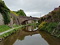
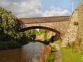
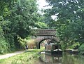
Grade II listed canal bridge in Macclesfield, Cheshire East, Cheshire, UK  | |||||
| Upload media | |||||
| Instance of | |||||
|---|---|---|---|---|---|
| Location | Macclesfield, Cheshire East, Cheshire, North West England, England | ||||
| Crosses |
| ||||
| Heritage designation |
| ||||
 | |||||
Brick arch bridge carrying residential road Richmond Hill over the Macclesfield Canal, Macclesfield, Cheshire East, Cheshire, England.
Bridge number 41 over the Macclesfield Canal.
Media in category "Bridge 41 (Richmond Hill), Macclesfield Canal"
The following 5 files are in this category, out of 5 total.
-
 Macclesfield Canal, Bridge Number 41.jpg 4,160 × 3,120; 3.08 MB
-
 Bridge No 41 (2), Macclesfield Canal.jpg 640 × 480; 559 KB
-
 Bridge No 41, Macclesfield Canal.jpg 1,024 × 768; 225 KB
-

-
,_Macclesfield_Canal.jpg)


