Category:Brockham
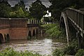
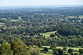
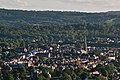
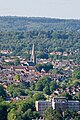
English: Brockham in a village in the Mole Valley district of Surrey, England. Originally named 'Brock Ham' (possibly a reference to the fact that it is home to badgers (known as brocks), it is approximately west of Reigate. The village lies south of Box Hill, with the River Mole flowing west through the village.
village and civil parish in the Mole Valley district of Surrey, England  | |||||
| Upload media | |||||
| Instance of | |||||
|---|---|---|---|---|---|
| Location | Mole Valley, Surrey, South East England, England | ||||
| Located in or next to body of water | |||||
| Population |
| ||||
| Area |
| ||||
 | |||||
Subcategories
This category has the following 6 subcategories, out of 6 total.
B
- Box Hill, Stepping Stones (15 F)
- Christ Church, Brockham (24 F)
- Brockham Lime Works (5 F)
- Brockham Pound (2 F)
R
- Royal Oak pub, Brockham (10 F)
Media in category "Brockham"
The following 200 files are in this category, out of 464 total.
(previous page) (next page)-
 'This is a Golf Course Watch area' - geograph.org.uk - 5812407.jpg 1,024 × 768; 536 KB
-
 12 - 16 and 18 - 20 The Borough - geograph.org.uk - 1825328.jpg 640 × 426; 88 KB
-
 2 - 10 The Borough - geograph.org.uk - 1825312.jpg 640 × 426; 116 KB
-

-
 A25 - geograph.org.uk - 3948811.jpg 640 × 430; 55 KB
-
 A25 at Deepdene Bridge - geograph.org.uk - 2674928.jpg 640 × 428; 110 KB
-
 Access to Thames Water facility - geograph.org.uk - 1824906.jpg 640 × 439; 112 KB
-
 Along the North Downs - geograph.org.uk - 2258349.jpg 640 × 425; 30 KB
-
 Anthony West House - geograph.org.uk - 4028365.jpg 800 × 530; 616 KB
-
 Approaching Boxhurst - geograph.org.uk - 5398093.jpg 662 × 1,000; 975 KB
-
 Beef Cattle by Boxhurst - geograph.org.uk - 3074720.jpg 4,288 × 3,216; 3.5 MB
-
 Belted Galloway Cattle - geograph.org.uk - 4799592.jpg 640 × 426; 57 KB
-
 Belted Galloway Cattle - geograph.org.uk - 5141499.jpg 640 × 426; 63 KB
-
 Belted Galloway Cattle - geograph.org.uk - 5141503.jpg 640 × 426; 64 KB
-
 Belted Galloway Cattle - geograph.org.uk - 5141504.jpg 640 × 426; 71 KB
-

-
 Belted Galloway, Lower Box Hill Farm - geograph.org.uk - 4422968.jpg 530 × 800; 613 KB
-
 Beltie calves - geograph.org.uk - 5398095.jpg 1,000 × 662; 1.08 MB
-
 Belties, Lower Boxhill Farm - geograph.org.uk - 5398117.jpg 1,000 × 662; 645 KB
-
 Bench beneath a yew-tree - geograph.org.uk - 5197257.jpg 1,024 × 759; 252 KB
-
 Betchworth Park Golf Club - geograph.org.uk - 1805249.jpg 640 × 426; 87 KB
-
 Betchworth Park Golf Course - geograph.org.uk - 1817252.jpg 640 × 426; 132 KB
-
 Betchworth Park Golf Course - geograph.org.uk - 1817266.jpg 640 × 426; 59 KB
-
 Betchworth Park Golf Course - geograph.org.uk - 5812421.jpg 1,024 × 768; 281 KB
-
 Betchworth, The 'Arkle Manor' - geograph.org.uk - 3590802.jpg 3,456 × 2,304; 4.29 MB
-
 Big Field - geograph.org.uk - 1829478.jpg 640 × 426; 59 KB
-
 Big Field - geograph.org.uk - 1829490.jpg 640 × 426; 61 KB
-
 Big Field - geograph.org.uk - 3253557.jpg 640 × 425; 412 KB
-
 Birch Cottage (geograph 6503978).jpg 1,024 × 684; 197 KB
-
 Birch Cottage and Century Cottage - geograph.org.uk - 1822567.jpg 640 × 426; 95 KB
-
 Bishop's Cottages - geograph.org.uk - 5141482.jpg 640 × 426; 64 KB
-
 Bishop's Cottages - geograph.org.uk - 5345216.jpg 640 × 425; 99 KB
-
 Bishop's Cottages, Chalkpit Lane - geograph.org.uk - 2271582.jpg 640 × 430; 48 KB
-
 Bishops Cottages and disused quarry - geograph.org.uk - 3033142.jpg 640 × 430; 46 KB
-
 Bonfire Under Construction - geograph.org.uk - 1553347.jpg 3,296 × 2,472; 3.88 MB
-
 Borough Bridge built 1737 - geograph.org.uk - 3039268.jpg 4,592 × 3,056; 7.31 MB
-
 Box Hill , Surrey looking towards Dorking - panoramio.jpg 2,244 × 1,499; 803 KB
-
 Box Hill - geograph.org.uk - 2224476.jpg 640 × 425; 71 KB
-
 Box Hill - geograph.org.uk - 2224518.jpg 640 × 425; 75 KB
-
 Box Hill - geograph.org.uk - 3048179.jpg 640 × 425; 376 KB
-
 Box Hill - geograph.org.uk - 3074713.jpg 4,288 × 3,216; 3.48 MB
-
 Box Hill - geograph.org.uk - 5308201.jpg 3,299 × 3,305; 7.48 MB
-
 Box Hill - geograph.org.uk - 5308208.jpg 4,000 × 2,666; 7.59 MB
-
 Box Hill - geograph.org.uk - 5308955.jpg 6,000 × 3,375; 6.87 MB
-
 Box Hill - geograph.org.uk - 5308967.jpg 5,939 × 3,959; 5.82 MB
-
 Box Hill - geograph.org.uk - 5308976.jpg 4,000 × 2,666; 7.97 MB
-
 Box Hill - geograph.org.uk - 5308992.jpg 3,946 × 2,630; 7.99 MB
-
 Box Hill - geograph.org.uk - 5309030.jpg 4,000 × 2,666; 7.2 MB
-
 Box Hill - geograph.org.uk - 5309040.jpg 6,000 × 4,000; 7.97 MB
-
 Box Hill - geograph.org.uk - 5309057.jpg 4,000 × 2,666; 7.17 MB
-
 Box Hill - geograph.org.uk - 5309147.jpg 4,000 × 2,666; 7.18 MB
-
 Box Hill - geograph.org.uk - 5693152.jpg 843 × 554; 218 KB
-
 Box Hill to Crawley - geograph.org.uk - 5147625.jpg 5,152 × 3,864; 6.57 MB
-
 Box Hill to Dorking - geograph.org.uk - 5147658.jpg 5,152 × 3,864; 6.5 MB
-
 Box Hill to Horsham - geograph.org.uk - 5147652.jpg 5,152 × 3,864; 6.39 MB
-
 Box Hill View - geograph.org.uk - 6036975.jpg 5,472 × 3,648; 4.85 MB
-
 Box Hill View - geograph.org.uk - 6036978.jpg 5,472 × 3,648; 5.7 MB
-
 Box Hill viewpoint - geograph.org.uk - 2224494.jpg 640 × 425; 77 KB
-
 Box Hill Viewpoint - geograph.org.uk - 3074678.jpg 4,288 × 3,216; 3.47 MB
-
 Box Hill, the viewpoint - geograph.org.uk - 558748.jpg 640 × 480; 70 KB
-
 Boxhill Farm - geograph.org.uk - 3030502.jpg 640 × 425; 481 KB
-
 Boxhill Farm Barns - geograph.org.uk - 5398118.jpg 1,000 × 662; 756 KB
-
 Boxhill from Lower Boxhill - geograph.org.uk - 3074766.jpg 4,288 × 3,216; 3.81 MB
-
 Boxhill Road - geograph.org.uk - 5309204.jpg 3,909 × 2,605; 7.84 MB
-
 Boxhill Road - geograph.org.uk - 5694717.jpg 640 × 480; 552 KB
-
 Boxhurst - geograph.org.uk - 5141492.jpg 640 × 426; 45 KB
-
 Boxhurst - geograph.org.uk - 5345235.jpg 640 × 426; 46 KB
-
 Bridge on Tilehurst Lane - geograph.org.uk - 5773921.jpg 640 × 428; 152 KB
-
 Bridges at Brockham - geograph.org.uk - 147641.jpg 640 × 480; 146 KB
-
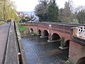 Bridges at Brockham - geograph.org.uk - 2326088.jpg 3,648 × 2,736; 3.2 MB
-
 Bridges of Brockham - geograph.org.uk - 3039249.jpg 4,592 × 3,056; 5.99 MB
-

-
 Brockham - geograph.org.uk - 1817177.jpg 640 × 431; 62 KB
-
 Brockham - geograph.org.uk - 3030526.jpg 640 × 425; 307 KB
-
 Brockham - geograph.org.uk - 3030541.jpg 640 × 425; 422 KB
-
 Brockham - geograph.org.uk - 4290714.jpg 800 × 530; 586 KB
-
 Brockham - geograph.org.uk - 847331.jpg 640 × 426; 82 KB
-
 Brockham Big Field - geograph.org.uk - 292983.jpg 640 × 480; 59 KB
-
 Brockham Big Field - geograph.org.uk - 856008.jpg 640 × 364; 46 KB
-
 Brockham Bridge - geograph.org.uk - 856023.jpg 640 × 480; 123 KB
-
 Brockham Bus Bunting - geograph.org.uk - 3016821.jpg 4,288 × 3,216; 3.72 MB
-
 Brockham church from Old School Lane - geograph.org.uk - 2319420.jpg 640 × 480; 103 KB
-
 Brockham from Box Hill - geograph.org.uk - 4235234.jpg 3,264 × 2,448; 1.83 MB
-
 Brockham from Box Hill - geograph.org.uk - 5494169.jpg 1,024 × 682; 203 KB
-
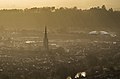
 Brockham from the North Downs Way - geograph.org.uk - 3271232.jpg 1,600 × 1,066; 260 KB
-
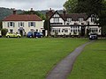 Brockham Green - geograph.org.uk - 3016140.jpg 4,288 × 3,216; 3.69 MB
-
 Brockham Green - geograph.org.uk - 4028316.jpg 800 × 530; 460 KB
-
 Brockham Green - geograph.org.uk - 4029693.jpg 800 × 530; 455 KB
-
 Brockham Green - geograph.org.uk - 5209281.jpg 2,048 × 1,536; 1.5 MB
-
 Brockham Green - geograph.org.uk - 5209868.jpg 2,048 × 1,536; 1.5 MB
-
 Brockham Green - geograph.org.uk - 5209884.jpg 2,048 × 1,536; 1.5 MB
-
 Brockham Green - geograph.org.uk - 5209886.jpg 2,048 × 1,536; 1.5 MB
-
 Brockham Green - geograph.org.uk - 56866.jpg 640 × 480; 120 KB
-
 Brockham Green - looking towards Christ Church - geograph.org.uk - 5783912.jpg 1,333 × 1,000; 1.09 MB
-
 Brockham Green village (1) - geograph.org.uk - 517273.jpg 640 × 427; 84 KB
-
 Brockham Green, North View - geograph.org.uk - 856765.jpg 640 × 427; 88 KB
-
 Brockham Green, Surrey (2) - geograph.org.uk - 517276.jpg 640 × 427; 91 KB
-
-

-
 Brockham Lane - geograph.org.uk - 3016820.jpg 4,288 × 3,216; 3.62 MB
-
 Brockham Lane - geograph.org.uk - 3253549.jpg 640 × 425; 445 KB
-
 Brockham Lane - geograph.org.uk - 3253561.jpg 640 × 425; 293 KB
-
 Brockham Lane at the junction of Reigate Road - geograph.org.uk - 5200463.jpg 2,048 × 1,536; 1.48 MB
-
 Brockham Lime Works - geograph.org.uk - 3016851.jpg 4,288 × 3,216; 3.32 MB
-
 Brockham Pillbox by footbridge over the river Mole.jpg 3,000 × 1,995; 3.03 MB
-
 Brockham Quarry - geograph.org.uk - 2155750.jpg 640 × 425; 129 KB
-
 Brockham Quarry - geograph.org.uk - 2155758.jpg 640 × 425; 101 KB
-
 Brockham Quarry - geograph.org.uk - 3016837.jpg 4,288 × 3,216; 3.83 MB
-
 Brockham Quarry - geograph.org.uk - 3016861.jpg 4,288 × 3,216; 3.78 MB
-
 Brockham Quarry - geograph.org.uk - 855549.jpg 640 × 427; 141 KB
-
 Brockham Quarry from above - geograph.org.uk - 3017102.jpg 4,288 × 3,216; 3.76 MB
-
 Brockham Village Hall - geograph.org.uk - 3016154.jpg 4,288 × 3,216; 3.35 MB
-
 Brockham Village Hall ^ Hair Studio - geograph.org.uk - 3043960.jpg 4,274 × 2,950; 5.81 MB
-
 Brockham Village Hall, Brockham Green, Brockham (July 2013).JPG 1,600 × 1,400; 604 KB
-
 Brockham Village Shop - geograph.org.uk - 3016782.jpg 4,288 × 3,216; 3.65 MB
-
 Brockham Warren - geograph.org.uk - 2271594.jpg 640 × 430; 42 KB
-
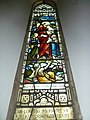
 Brockham, Altar Panel - geograph.org.uk - 3016772.jpg 4,288 × 3,216; 2.34 MB
-
 Brockham, Borough Bridge - geograph.org.uk - 3016789.jpg 4,288 × 3,216; 3.54 MB
-
 Brockham, Mar 85 (53314468213).jpg 2,560 × 1,920; 2.48 MB
-
 Brockham, Mar 85 (53314581709).jpg 2,518 × 1,868; 2.46 MB
-
 Brockham, The Avenue - geograph.org.uk - 4538648.jpg 4,608 × 3,456; 6.48 MB
-
 Brockham, Timber-Framing - geograph.org.uk - 3016779.jpg 4,288 × 3,216; 3.54 MB
-
 Brockham, Well Head - geograph.org.uk - 3016786.jpg 4,288 × 3,216; 3.66 MB
-
 Brooklands - geograph.org.uk - 4029711.jpg 800 × 530; 488 KB
-
 Building the Brockham Bonfire - geograph.org.uk - 3723937.jpg 800 × 530; 555 KB
-
 Building the Brockham Bonfire - geograph.org.uk - 3723944.jpg 800 × 530; 498 KB
-
 Building the Brockham Bonfire - geograph.org.uk - 3723949.jpg 800 × 530; 599 KB
-
 Building the Brockham Bonfire - geograph.org.uk - 3723955.jpg 800 × 530; 487 KB
-
 Bushbury Farm - geograph.org.uk - 1806844.jpg 640 × 428; 117 KB
-
 Bushbury Farm - geograph.org.uk - 1806861.jpg 640 × 426; 75 KB
-
 Bushbury Farm - geograph.org.uk - 4451568.jpg 4,608 × 3,456; 6.15 MB
-
 Bushbury Farm - geograph.org.uk - 5208679.jpg 2,048 × 1,536; 1.09 MB
-
 Bushbury Farm - geograph.org.uk - 5770758.jpg 640 × 428; 119 KB
-
 Bushbury Lane - geograph.org.uk - 1806812.jpg 640 × 426; 84 KB
-
 Bushbury, Park Pale Lane - geograph.org.uk - 4451549.jpg 4,608 × 3,456; 6.2 MB
-
 Car park on Zig Zag Road - geograph.org.uk - 2266584.jpg 640 × 426; 130 KB
-
 Castle Gardens - geograph.org.uk - 2226014.jpg 640 × 425; 105 KB
-
 Cereal fields west of Brockham - geograph.org.uk - 2987264.jpg 1,024 × 768; 174 KB
-
 Chalk Grassland, Brockham Quarry - geograph.org.uk - 3016855.jpg 4,288 × 3,216; 3.57 MB
-
 Christ Church - geograph.org.uk - 4029681.jpg 530 × 800; 420 KB
-
 Christ Church, Brockham - geograph.org.uk - 5209280.jpg 2,042 × 1,528; 1.37 MB
-
 Christ Church, Brockham Green at dusk - geograph.org.uk - 3375879.jpg 1,024 × 767; 263 KB
-
 Christ Church, Brockham, banner - geograph.org.uk - 3617054.jpg 480 × 640; 65 KB
-
 Christ Church, Brockham, July 2013 - geograph.org.uk - 3615917.jpg 640 × 480; 74 KB
-
 Christ Church, Brockham, lectern - geograph.org.uk - 3617050.jpg 480 × 640; 69 KB
-
 Christ Church, Brockham, main altar - geograph.org.uk - 3617046.jpg 640 × 471; 70 KB
-

-
-

-
 Christ Church, Brockham, pulpit - geograph.org.uk - 3617052.jpg 467 × 640; 65 KB
-
-
 Christ Church, Brockham, side altar - geograph.org.uk - 3617047.jpg 640 × 480; 74 KB
-
 Christ Church, Brockham, spire - geograph.org.uk - 3617041.jpg 480 × 640; 71 KB
-
-

-

-

-

-

-
-
-

-

-

-

-

-
 Christ Church, Brockham, war memorial - geograph.org.uk - 3617049.jpg 640 × 480; 107 KB
-
 Christ Church, Brockham, west wall - geograph.org.uk - 3617048.jpg 640 × 480; 50 KB
-
 Church Side and Holly Cottage - geograph.org.uk - 4029679.jpg 800 × 530; 519 KB
-
 Clump of trees - geograph.org.uk - 5345233.jpg 640 × 426; 58 KB
-
 Coach Road, Brockham - geograph.org.uk - 5812381.jpg 1,024 × 768; 443 KB
-
 Coach Road, Brockham - geograph.org.uk - 5812395.jpg 1,024 × 768; 416 KB
-
 Common Box (Buxus sempervirens), Box Hill - geograph.org.uk - 5494183.jpg 682 × 1,024; 120 KB
-

-
 Dead tree - geograph.org.uk - 1817243.jpg 426 × 640; 84 KB
-
 Decrepitude at Bushbury Farm - geograph.org.uk - 5770680.jpg 640 × 428; 128 KB
-
 Deepdene Bridge - geograph.org.uk - 2227357.jpg 640 × 425; 113 KB
-
 Denbies - geograph.org.uk - 2224441.jpg 640 × 425; 124 KB
-
 Denbies Vineyard from Box Hill - geograph.org.uk - 2152827.jpg 640 × 425; 77 KB
-
 Denbies Vineyard from Box Hill - geograph.org.uk - 2152830.jpg 640 × 425; 75 KB
-
 Denbies Vineyard from Box Hill - geograph.org.uk - 3074626.jpg 4,288 × 3,216; 3.54 MB
-
 Denmark House - geograph.org.uk - 1822407.jpg 640 × 426; 84 KB
-
 Disused Lime Kilns - geograph.org.uk - 3016841.jpg 4,288 × 3,216; 3.71 MB
-
 Dolly Farm, Brockham - geograph.org.uk - 5813244.jpg 1,024 × 768; 277 KB
-
 Dorking - geograph.org.uk - 3030465.jpg 640 × 425; 377 KB
-
 Dorking - geograph.org.uk - 3030515.jpg 640 × 425; 392 KB
-
 Dorking from Box Hill - geograph.org.uk - 2224410.jpg 425 × 640; 128 KB
-
 Dorking from Box Hill - geograph.org.uk - 4290708.jpg 800 × 530; 426 KB
-
 Dorking from Box Hill - geograph.org.uk - 5494176.jpg 1,024 × 682; 197 KB
-
 Dorking Sewage Works - geograph.org.uk - 3074650.jpg 4,288 × 3,216; 3.9 MB
-
 Downhill along the North Downs Way - geograph.org.uk - 5196510.jpg 768 × 1,024; 369 KB
-
 The 'Duke's Head', Brockham Green, Surrey - geograph.org.uk - 517265.jpg 640 × 427; 107 KB
-
 East from Box Hill - geograph.org.uk - 4290740.jpg 800 × 530; 550 KB
-
 East from Box Hill - geograph.org.uk - 4290760.jpg 800 × 530; 519 KB
-
 East from Box Hill - geograph.org.uk - 4290764.jpg 800 × 530; 494 KB
-
 East of Dorking - geograph.org.uk - 5311424.jpg 6,000 × 4,000; 7.53 MB
-
 East of Dorking - geograph.org.uk - 5311430.jpg 4,000 × 2,666; 6.62 MB
-
 Eastern slopes of Box Hill, 1967 - geograph.org.uk - 3304879.jpg 640 × 348; 51 KB
-

-
 Entering Brockham - geograph.org.uk - 1822357.jpg 640 × 426; 107 KB


.jpg)


_-_geograph.org.uk_-_517273.jpg)

_-_geograph.org.uk_-_517276.jpg)


.JPG)


.jpg)
.jpg)


_-_geograph.org.uk_-_3617035.jpg)
_-_geograph.org.uk_-_3617036.jpg)
_-_geograph.org.uk_-_3617037.jpg)


_-_geograph.org.uk_-_3617017.jpg)
_-_geograph.org.uk_-_3617031.jpg)
_-_geograph.org.uk_-_3617032.jpg)
_-_geograph.org.uk_-_3617033.jpg)
_-_geograph.org.uk_-_3617034.jpg)
_-_geograph.org.uk_-_3617018.jpg)
_-_geograph.org.uk_-_3617021.jpg)
_-_geograph.org.uk_-_3617022.jpg)
_-_geograph.org.uk_-_3617023.jpg)
_-_geograph.org.uk_-_3617025.jpg)
_-_geograph.org.uk_-_3617026.jpg)
_-_geograph.org.uk_-_3617027.jpg)
_-_geograph.org.uk_-_3617029.jpg)


,_Box_Hill_-_geograph.org.uk_-_5494183.jpg)


