Category:Brodtener Ufer
This is the category of the protected area listed at WDPA under the ID 320099
|
This is the category of the protected area listed at WDPA under the ID 555537275
|
 | |||||
| Upload media | |||||
| Instance of | |||||
|---|---|---|---|---|---|
| Named after |
| ||||
| Located in protected area | |||||
| Location | Lübeck, Schleswig-Holstein, Germany | ||||
| Located in or next to body of water | |||||
 | |||||
Subcategories
This category has the following 4 subcategories, out of 4 total.
Media in category "Brodtener Ufer"
The following 34 files are in this category, out of 34 total.
-
 20190509 112720 Brodten Hof Werner.jpg 4,032 × 1,960; 2.9 MB
-
 Abendlicher Blick von der Niendorfer Seebrücke auf das Brodtener Steilufer.jpg 4,000 × 2,250; 4.9 MB
-
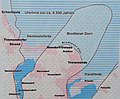 Ausschnitt aus Info-Tafel Brodtener Ufer 2022.jpg 1,772 × 1,468; 533 KB
-
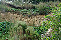
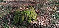 Baumstumpf bemoost am Brodtener Ufer.jpg 4,000 × 1,936; 5.46 MB
-
 Blick Richtung Timmendorfer Strand - panoramio.jpg 3,283 × 1,938; 2.74 MB
-
 Brodten, 23570 Lübeck, Germany - panoramio (3).jpg 1,600 × 1,067; 858 KB
-
 Brodten, 23570 Lübeck, Germany - panoramio (4).jpg 1,600 × 1,067; 1.02 MB
-
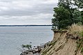
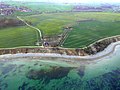
 Brodtener Steilufer - panoramio.jpg 2,832 × 760; 872 KB
-

-

-

-

-

-
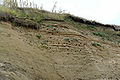
 Brodtener Steilufer, Lübeck, Schleswig-Holstein.jpg 4,928 × 3,264; 11.74 MB
-
 Brodtener Ufer 2018-05-12.jpg 3,264 × 1,840; 1.69 MB
-
 Brodtener Ufer Sept 2014b.jpg 4,212 × 3,008; 3.04 MB
-
 BrodtenerUfer-01.jpg 2,000 × 658; 347 KB
-
 BrodtenerUfer-03.jpg 2,000 × 1,333; 1.24 MB
-
 BrodtenerUfer-04.jpg 2,000 × 1,333; 1.82 MB
-
 Brodtner Steilufer.jpg 2,288 × 1,712; 1.01 MB
-
 Brodtner-Steilufer.jpg 2,500 × 1,667; 835 KB
-
 BrodtnerUfer seeblick-27.04.2012.jpg 1,024 × 768; 125 KB
-
 Café-Restaurant Hermannshöhe 2021.jpg 4,032 × 1,960; 3.15 MB
-
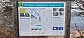 Info-Tafel Brodtener Ufer 2022.jpg 4,000 × 1,800; 3.17 MB
-
 Infotafel zum Landschaftsschutzgebiet.JPG 2,560 × 1,920; 2.21 MB
-
 LSG Brodtener Winkel Rapsfeld.JPG 2,592 × 1,944; 3.64 MB
-
 Lübeck, Germany - panoramio (1).jpg 1,568 × 1,080; 655 KB
-
 Lübeck, Germany - panoramio (2).jpg 1,626 × 1,080; 711 KB
-
 Niendorf Brodtener Ufer 2018-05-12.jpg 3,264 × 1,840; 1.48 MB
-
 OLYMPUS DIGITAL CAMERA - panoramio - mroszewski (36).jpg 1,600 × 1,200; 125 KB
-
 Seetempel Travemünde (um 1860).jpg 2,399 × 1,772; 1.57 MB
-
 Sonnenuntergang bei Niendorf - panoramio.jpg 3,263 × 1,938; 1.27 MB
-
 WP Seetempel Travemünde.jpg 2,490 × 1,772; 965 KB
-
 Zisterne eines Zwillingbaumes am Brodtener Ufer.jpg 4,000 × 1,936; 4.46 MB


.jpg)
.jpg)
.jpg)
.jpg)
.jpg)
.jpg)


.jpg)
.jpg)

.jpg)
.jpg)


