Category:Buckskin Mountain (Arizona-Utah)
ridge in Coconino County, Arizona and Kane County, Utah in the United States | |||||
| Upload media | |||||
| Instance of | |||||
|---|---|---|---|---|---|
| Location |
| ||||
| Length |
| ||||
| Elevation above sea level |
| ||||
| Different from | |||||
 | |||||
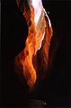
English: Media related to Buckskin Mountain (Arizona-Utah) a 16-mile (26 km) ridge in Coconino County, Arizona and Kane County, Utah in the Southwestern United States, between Rock Canyon (on the northern border of the Kaibab National Forest) on the south, the Vermillion Cliffs to the northwest, and Buckskin Gulch (southwest of Fivemile Mountain) on the north, The Cockscomb and Paria Canyon-Vermilion Cliffs Wilderness on the east, and the Kaibab Plateau on the southeast.
- Note: Many maps may not reflect this description as the the ridge was only defined as such by the United States Geological Survey in February 1989.
Media in category "Buckskin Mountain (Arizona-Utah)"
This category contains only the following file.
-
 Buckskin Gulch.jpg 1,176 × 1,774; 96 KB
