Category:Byrum Kirke
| Object location | | View all coordinates using: OpenStreetMap |
|---|
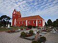
church building in Læsø Municipality, Denmark  | |||||
| Upload media | |||||
| Instance of | |||||
|---|---|---|---|---|---|
| Location | Byrum, Læsø Municipality, North Denmark Region, Denmark | ||||
| Street address |
| ||||
| Diocese | |||||
| Inception |
| ||||
| Religion or worldview | |||||
 | |||||
Media in category "Byrum Kirke"
The following 18 files are in this category, out of 18 total.
-
 Byrum Kirke Skt Barbara.JPG 1,309 × 1,618; 368 KB
-
 Byrum Kirke.JPG 2,288 × 1,712; 1,006 KB
-
 Byrum Kirke2.JPG 2,174 × 1,630; 477 KB
-
 Byrum Kirke3.JPG 2,288 × 1,712; 844 KB
-
 Byrumkirke læsø.JPG 1,299 × 843; 380 KB
-
 Hans Andersen Brendekilde - Byrum Kirke på Læsø.png 2,000 × 1,550; 7.25 MB
-
 Kirche Byrum.jpg 4,896 × 3,672; 6.74 MB
-
 Nordenskirker Byrum(01).jpg 800 × 556; 102 KB
-
 Nordenskirker Byrum(06).jpg 800 × 564; 81 KB
-
 Nordenskirker Byrum(07).jpg 403 × 600; 66 KB
-
 Nordenskirker Byrum(08).jpg 415 × 600; 75 KB
-
 Nordenskirker Byrum(09).jpg 408 × 600; 78 KB
-
 Nordenskirker Byrum(10).jpg 400 × 600; 78 KB
-
 Nordenskirker Byrum(11).jpg 400 × 600; 71 KB
-
 Nordenskirker Byrum(12).jpg 400 × 600; 55 KB
-
 Nordenskirker Byrum(15).jpg 405 × 600; 45 KB
-
 Nordenskirker Byrum(24).jpg 401 × 600; 65 KB
-
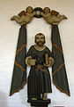 Sct Laurentius, Byrum Kirke.JPG 1,065 × 1,517; 219 KB


.jpg)
.jpg)
.jpg)
.jpg)
.jpg)
.jpg)
.jpg)
.jpg)
.jpg)
.jpg)
