Category:CIA World Factbook maps of the world
Media in category "CIA World Factbook maps of the world"
The following 58 files are in this category, out of 58 total.
-
 "Political World" CIA World Factbook map 2005.svg 2,753 × 1,538; 2.38 MB
-
 1-12 Color Map World.png 4,572 × 2,500; 2.63 MB
-
 Antarctic Circle.jpg 634 × 311; 275 KB
-
 ARCTIC CIRCLE 021106.jpg 634 × 311; 275 KB
-
 CIA Political World Map 2002.jpg 3,206 × 1,698; 874 KB
-
 CIA World Factbook 2016 physical world map.svg 512 × 259; 13.61 MB
-
 CIA World Map Physical 2021.pdf 6,600 × 3,600; 3.64 MB
-
 CIA World Map Political 2021.pdf 6,300 × 3,600; 22.53 MB
-
 CIA World Physical Map (2023).pdf 6,600 × 3,600; 3.55 MB
-
 CIA World Political Map (2023).pdf 6,300 × 3,600; 8.02 MB
-
 CIA WorldFactBook-Political world ID Peta Dunia.svg 2,760 × 1,502; 1.57 MB
-
 CIA WorldFactBook-Political world pdf2svg.svg 512 × 277; 2.79 MB
-
 CIA WorldFactBook-Political world-ee.png 4,792 × 2,604; 2.54 MB
-
 CIA WorldFactBook-Political world.pdf 6,300 × 3,600; 23.25 MB
-
 CIA WorldFactBook-Political world.png 6,000 × 3,271; 4.39 MB
-
 CIA WorldFactBook-Political world.svg 2,760 × 1,502; 1.47 MB
-
 Cylindrical Equal-Area Projection Oblique Case Map of the World.png 634 × 270; 46 KB
-
 Dijagram Zemljopisne Sirine.PNG 717 × 306; 107 KB
-
 Exports by country map copy3.png 1,357 × 628; 54 KB
-
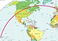 Flight path TN064.jpg 2,486 × 1,756; 661 KB
-
 Gdp real growth rate 2007 CIA Factbook.PNG 1,350 × 625; 50 KB
-
 GDP real growth rate CIA Factbook.PNG 1,350 × 625; 50 KB
-
 Map of the world 1998.jpg 11,527 × 6,505; 7.54 MB
-
 Map of the world by the US Gov as of 2016 no legend.svg 3,464 × 1,755; 21.61 MB
-
 Map of the world with countries and dependencies.svg 512 × 278; 2.95 MB
-
 Physical Map of the World (2021).svg 1,800 × 912; 17.19 MB
-
 Physical World Map.svg 1,920 × 973; 8.1 MB
-
 Physical world.svg 3,168 × 2,448; 14.22 MB
-
 Political Map of the World (august 2013).png 11,479 × 6,269; 5.35 MB
-
 Political Map of the World (august 2013).svg 3,464 × 1,897; 12.18 MB
-
 Political Map of the World (january 2015).pdf 6,600 × 5,100; 1.5 MB
-
 Political Map of the World (january 2015).png 17,392 × 9,478; 16.84 MB
-
 Political map of the World (January 2015).svg 3,444 × 1,875; 11.01 MB
-
 Political map of the World (June 2009).jpg 700 × 381; 265 KB
-
 Political Map of the World (june 2010).png 11,650 × 6,322; 5.3 MB
-
 Political Map of the World (june 2010).svg 3,524 × 1,913; 3.39 MB
-
 Political map of the World (November 2011).png 4,572 × 2,500; 3.46 MB
-
 Political Map of the World, 2013.png 7,677 × 4,196; 2.51 MB
-
 Political map of the world, April 2001 (3856492780).jpg 2,000 × 1,172; 1.82 MB
-
 Political Map of the World.png 4,572 × 2,500; 3.43 MB
-
 Political World Map (with disputed territories).png 6,000 × 3,271; 3.95 MB
-
 Public debt percent gdp world map.PNG 1,357 × 628; 41 KB
-
 Standard time zones of the world (2012) - Pacific Centered.svg 1,672 × 856; 1.35 MB
-
 Standard Time Zones of the World (October 2015).svg 1,672 × 892; 15.11 MB
-
 Standard time zones of the world.png 4,000 × 2,156; 2.49 MB
-
 Weltkarte.jpg 2,804 × 1,521; 715 KB
-
 World - time zones map (2011).svg 512 × 273; 9.56 MB
-
 World - time zones map (2014).svg 512 × 276; 4.99 MB
-
 World Map (political).svg 1,920 × 975; 4.28 MB
-
 World map 2004 CIA large 1.7m whitespace removed.jpg 3,599 × 1,826; 1.75 MB
-
 World map 2004 CIA large 2m.jpg 4,000 × 2,949; 1.51 MB
-
 World map 2004 CIA large.jpg 4,595 × 2,335; 2.24 MB
-
 World map 2011 CIA World Factbook.svg 3,465 × 1,795; 26.51 MB
-
 World map CIA small.jpg 180 × 87; 7 KB
-
 World map pol 2005 v02 GRK.svg 2,753 × 1,538; 2.39 MB
-
 World-CIA WFB Map (2004).png 635 × 272; 27 KB
-
 WorldMapLongLat-eq-circles-tropics-non-sanstext.png 634 × 311; 139 KB
-
 Політична карта світу.svg 2,760 × 1,502; 1.51 MB


.svg)


.png)
.svg)
.png)
.svg)
.jpg)
.png)
.svg)
.png)

.jpg)

.png)

_-_Pacific_Centered.svg)
.svg)


.svg)
.svg)
.svg)


.png)

