Category:Cairo Ohio River Bridge
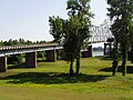
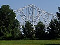
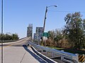
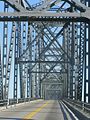
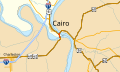
English: This road bridge carries U.S. Routes 51, 60, and 62 over the Ohio River just upstream from its mouth at the Mississippi River. The northeast end of this bridge in Ballard County, Kentucky, northwest of Wickliffe; the southwest end is in Cairo, Alexander County, Illinois. Just south of this bridge is the Cairo Mississippi River Bridge over the Mississippi River.
| Object location | | View all coordinates using: OpenStreetMap |
|---|
bridge in Kentucky and Cairo, Illinois  | |||||
| Upload media | |||||
| Instance of | |||||
|---|---|---|---|---|---|
| Location | |||||
| Crosses | |||||
| Inception |
| ||||
| Date of official opening |
| ||||
| Different from | |||||
 | |||||
Media in category "Cairo Ohio River Bridge"
The following 23 files are in this category, out of 23 total.
-
 2018 Cairo Ohio River Bridge.jpg 4,608 × 3,456; 3.18 MB
-
 Cairo Ohio River Bridge at sunset.jpg 2,133 × 1,418; 248 KB
-
 Cairo Ohio River Bridge P6190063.JPG 1,984 × 1,488; 675 KB
-
 Cairo Ohio River Bridge P6190064.JPG 1,984 × 1,488; 641 KB
-
 Cairo Ohio River Bridge P6190067.JPG 1,984 × 1,488; 605 KB
-
 Cairo Ohio River Bridge P6190069.JPG 1,984 × 1,488; 627 KB
-
 Cairo Ohio River Bridge P6190072.JPG 1,984 × 1,488; 601 KB
-
 Cairo Ohio River Bridge P6190073.JPG 1,984 × 1,488; 606 KB
-
 Cairo Ohio River Bridge P6190074.JPG 1,984 × 1,488; 595 KB
-
 Cairo Ohio River Bridge P6190077.JPG 1,984 × 1,488; 599 KB
-
 Cairo Ohio River Bridge P6190079.JPG 1,984 × 1,488; 607 KB
-
 Cairo Ohio River Bridge P6190080.JPG 1,984 × 1,488; 622 KB
-
 Cairo Ohio River Bridge PA250458.JPG 3,072 × 2,304; 1.13 MB
-
 Cairo Ohio River Bridge PA250459.JPG 2,304 × 3,072; 985 KB
-
 Cairo Ohio River Bridge PA250466.JPG 3,072 × 2,304; 1.12 MB
-
 Cairo Ohio River Bridge.jpg 1,818 × 1,228; 905 KB
-
 CairoOhioRiverBridge.jpg 3,390 × 1,693; 2.7 MB
-
 IL-KY-Bridge signs.jpg 4,368 × 2,912; 5.26 MB
-

-

-
 Ohio River Bridge Cairo to Wickliffe Interior.JPG 800 × 1,067; 164 KB
-
 P6190068(Cairo-IL Ohio R Bridge).JPG 1,984 × 1,488; 606 KB
-
 US 60-62 IL map.svg 1,026 × 608; 181 KB


.JPG)
