Category:California State Route 60
state highway in Los Angeles, San Bernardino, and Riverside counties in California, United States    | |||||
| Upload media | |||||
| Instance of | |||||
|---|---|---|---|---|---|
| Location |
| ||||
| Transport network |
| ||||
| Connects with | |||||
| Owned by | |||||
| Maintained by | |||||
| Inception |
| ||||
| Length |
| ||||
| Terminus | |||||
 | |||||
Subcategories
This category has the following 2 subcategories, out of 2 total.
L
Media in category "California State Route 60"
The following 16 files are in this category, out of 16 total.
-
 60freeway.jpg 1,572 × 984; 426 KB
-
 60pomonafreeway.jpg 1,572 × 984; 412 KB
-
 CA State Route 60 at University exit.jpg 4,416 × 1,533; 2.05 MB
-
 CA-60 I-5 I-10 interchange gantry sign.jpg 1,771 × 354; 774 KB
-
 California 60.svg 385 × 401; 14 KB
-
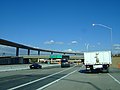
 California SR 60-I-710 sign.jpg 6,624 × 1,818; 1.89 MB
-
 California State Route 60, University Avenue Overpass.jpg 1,600 × 720; 375 KB
-
 California State Route 60.svg 1,152 × 640; 312 KB
-
 Diamond Bar Merge from United 793 (6306325762).jpg 1,600 × 1,200; 405 KB
-
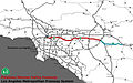
 East LA Interchange map.svg 806 × 538; 362 KB
-
 I215-CA60-CA91.jpg 2,848 × 2,136; 2.95 MB
-
 Int605nRoad-Exit19-CA60 (30403094915).jpg 2,400 × 1,600; 1.8 MB
-

-

-
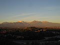 Phillips Ranch Photo.jpg 4,000 × 3,000; 1.69 MB
-
 Pomona Freeway.jpg 800 × 564; 186 KB


.jpg)


.jpg)

,_A_UNIQUE_MULTI-AGENCY_AIR_POLLUTION_RESEARCH_STUDY_SPONSORED_BY_THE..._-_NARA_-_552374.jpg)
