Category:Camboglanna
Roman auxiliary troop fort in the north west of England .png) | |||||
| Upload media | |||||
| Instance of | |||||
|---|---|---|---|---|---|
| Part of |
| ||||
| Culture | |||||
| Location | Walton, Carlisle, Cumbria, North West England, England | ||||
 | |||||
- Deutsch: Camboglanna war ein römisches Kastell der Hilfstruppen im Nordwesten von England, County Cumbria, District Carlisle, Parish Castlesteads. Das oberirisch nicht sichtbare Bodendenkmal umfasst neben dem Areal der römischen Festung auch die Überreste des Hadrianswalls bei Castlesteads und der Abschnitt des vallum zwischen dem Kastell und dem Tal des Cam Beck im Westen.
- English: Camboglanna (with the modern name of Castlesteads) was a Roman fort. It was the twelfth fort on Hadrian's Wall counting from the east, between Banna (Birdoswald) to the east and Uxelodunum (Stanwix) to the west. It was almost 7 miles (11 km) west of Birdoswald, on a high bluff commanding the Cambeck Valley. It guarded an important approach to the Wall and also watched the east bank of the Cambeck against raiders from the Bewcastle area. The site was drastically levelled in 1791 when the gardens of Castlesteads House were laid over it.
-
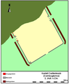 Befundplan des Kastells nach der Ausgrabung 1934
 -
 Plan des Kastell Camboglanna (irrtümlich als Petrianis bezeichnet) am Hadrianswall von 1857.
 -
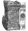 Iupiteraltar der cohors II Tungorum
 -
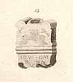
 Altar dedicated to the Discipline of the Emperor(s)


Media in category "Camboglanna"
The following 29 files are in this category, out of 29 total.
-
Altar d. Disciplina Castlesteads.png 282 × 270; 26 KB
-
BP Castlesteads (Camboglanna).png 636 × 774; 52 KB
-
Camboglanna-MacLauchlanWeb.jpg 466 × 800; 23 KB
-
 Camboglanna.jpg 800 × 613; 141 KB
-
 Camboglanna.png 1,008 × 1,002; 2.32 MB
-
 Roman Antiquities at Castlesteads in Cumberland Figure 01.jpg 2,909 × 3,486; 3.25 MB
-
 Roman Antiquities at Castlesteads in Cumberland Figure 02.jpg 1,633 × 2,627; 1.41 MB
-
 Roman Antiquities at Castlesteads in Cumberland Figure 03.jpg 1,633 × 3,744; 1.95 MB
-
 Roman Antiquities at Castlesteads in Cumberland Figure 04.jpg 1,105 × 1,511; 387 KB
-
 Roman Antiquities at Castlesteads in Cumberland Figure 05.jpg 1,535 × 1,645; 750 KB
-
 Roman Antiquities at Castlesteads in Cumberland Figure 06.jpg 2,700 × 2,812; 2.3 MB
-
 Roman Antiquities at Castlesteads in Cumberland Figure 07.jpg 1,706 × 2,639; 1.44 MB
-
 Roman Antiquities at Castlesteads in Cumberland Figure 08.jpg 1,400 × 1,105; 517 KB
-
 Roman Antiquities at Castlesteads in Cumberland Figure 09.jpg 1,285 × 1,187; 544 KB
-
 Roman Antiquities at Castlesteads in Cumberland Figure 10.jpg 1,883 × 3,355; 2.96 MB
-
 Roman Antiquities at Castlesteads in Cumberland Figure 11.jpg 2,088 × 3,527; 3.8 MB
-
 Roman Antiquities at Castlesteads in Cumberland Figure 12.jpg 1,474 × 1,694; 1,021 KB
-
 Roman Antiquities at Castlesteads in Cumberland Figure 13.jpg 1,179 × 1,318; 531 KB
-
 Roman Antiquities at Castlesteads in Cumberland Figure 14.jpg 2,692 × 1,645; 1.86 MB
-
 Roman Antiquities at Castlesteads in Cumberland Figure 15.jpg 2,185 × 3,617; 3.36 MB
-
 Roman Antiquities at Castlesteads in Cumberland Figure 16.jpg 1,842 × 1,850; 1.29 MB
-
 Roman Antiquities at Castlesteads in Cumberland Figure 17.jpg 1,817 × 1,359; 891 KB
-
 Roman Antiquities at Castlesteads in Cumberland Figure 18.jpg 623 × 966; 253 KB
-
 Roman Antiquities at Castlesteads in Cumberland Figure 19.jpg 795 × 1,072; 341 KB
-
 Roman Antiquities at Castlesteads in Cumberland Figure 20.jpg 1,940 × 1,056; 777 KB
-
 Roman Antiquities at Castlesteads in Cumberland Figure 21.jpg 2,382 × 3,895; 4.57 MB
-
 Roman Antiquities at Castlesteads in Cumberland Figure 22.jpg 1,670 × 1,899; 1.41 MB
-
 Roman Antiquities at Castlesteads in Cumberland Figure 24.jpg 607 × 664; 138 KB
-
 Roman Antiquities at Castlesteads in Cumberland Figure 25.jpg 607 × 549; 150 KB


