Category:Can Duran (Maçanet de Cabrenys)
Català: Can Duran (Maçanet de Cabrenys)
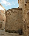
This is a category about a building indexed in the Catalan heritage register as Bé Cultural d'Interès Local (BCIL) under the reference IPA-19877. |
| Object location | | View all coordinates using: OpenStreetMap |
|---|
house in Maçanet de Cabrenys, Spain  Can Duran al darrere de l'absis | |||||
| Upload media | |||||
| Instance of | |||||
|---|---|---|---|---|---|
| Location | Maçanet de Cabrenys, Alt Empordà, Comarques Gironines, Catalonia | ||||
| Street address |
| ||||
| Architectural style | |||||
| Heritage designation |
| ||||
| Inception |
| ||||
| Elevation above sea level |
| ||||
 | |||||
Media in category "Can Duran (Maçanet de Cabrenys)"
This category contains only the following file.
-
 Maçanet de Cabrenys 2012 07 19 17.jpg 3,016 × 3,792; 7.87 MB