Category:Cape Cleveland Light
| Object location | | View all coordinates using: OpenStreetMap |
|---|
lighthouse in Queensland, Australia  | |||||
| Upload media | |||||
| Instance of | |||||
|---|---|---|---|---|---|
| Location | Queensland, AUS | ||||
| Heritage designation |
| ||||
| Inception |
| ||||
 | |||||
English: Cape Cleveland Light is an active heritage-listed lighthouse located on the northern tip of Cape Cleveland, a promontory projecting into the Coral Sea west of Cleveland Bay in the locality of Cape Cleveland about 40 kilometres (25 mi) east of Townsville, Queensland, Australia. The lighthouse marks the northern point of the Cape, and the entrance to Cleveland Bay.
Media in category "Cape Cleveland Light"
The following 10 files are in this category, out of 10 total.
-
 Cape Cleveland - Plan, 1927.jpg 1,260 × 1,997; 199 KB
-
 Cape Cleveland Cottages, 1878.jpg 2,953 × 2,499; 701 KB
-
 Cape Cleveland Light closeup, 1917.jpg 598 × 785; 70 KB
-
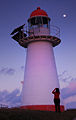 Cape Cleveland Light dusk.jpg 1,268 × 2,000; 1.36 MB
-
 Cape Cleveland Light keepers house.jpg 3,008 × 2,000; 3.96 MB
-
 Cape Cleveland Light, 1917.jpg 425 × 315; 59 KB
-
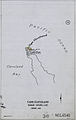
 Cape Cleveland Lighthouse - Layout of Lighthouse Station, 1952.jpg 2,953 × 2,196; 572 KB
-
 Cape Cleveland Lighthouse, north Queensland.jpg 664 × 1,000; 218 KB
-
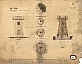 Dent Island and Cape Cleveland Lighthouses - Tower, 1878.jpg 2,953 × 2,317; 776 KB
-
 Northern Elevation Proposed New Watch House - Cape Moreton & Cape Cleveland, 1942.jpg 2,362 × 1,663; 204 KB


