Category:Cape Kamui
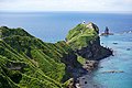
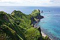
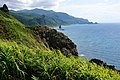
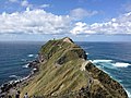
English: Cape Kamui is a rocky headland in Shakotan, Hokkaidō, on the northwestern tip of the Shakotan Peninsula.
| Object location | | View all coordinates using: OpenStreetMap |
|---|
cape with steep cliff jutting out into the Sea of Japan  .jpg) | |||||
| Upload media | |||||
| Instance of | |||||
|---|---|---|---|---|---|
| Named after |
| ||||
| Location | Shakotan, Shakotan district, Hokkaido, Japan | ||||
| Located in or next to body of water | |||||
| Different from | |||||
 | |||||
Media in category "Cape Kamui"
The following 52 files are in this category, out of 52 total.
-
 130823 Cape Kamui Shakotan Hokkaido Japan01s3.jpg 4,740 × 3,160; 10.93 MB
-
 130823 Cape Kamui Shakotan Hokkaido Japan02s3.jpg 4,800 × 3,200; 11.36 MB
-
 130823 Cape Kamui Shakotan Hokkaido Japan03s3.jpg 4,912 × 3,264; 12.09 MB
-
 130823 Cape Kamui Shakotan Hokkaido Japan04s3.jpg 4,912 × 3,264; 14.54 MB
-
 130823 Cape Kamui Shakotan Hokkaido Japan05s3.jpg 4,912 × 3,264; 13.46 MB
-
 130823 Cape Kamui Shakotan Hokkaido Japan06s3.jpg 4,912 × 3,264; 11.75 MB
-
 130823 Cape Kamui Shakotan Hokkaido Japan08s3.jpg 3,100 × 4,650; 11.86 MB
-
 130823 Cape Kamui Shakotan Hokkaido Japan09s3.jpg 4,912 × 3,264; 13.11 MB
-
 130823 Cape Kamui Shakotan Hokkaido Japan10n.jpg 4,800 × 3,200; 9.66 MB
-
 130823 Cape Kamui Shakotan Hokkaido Japan11s3.jpg 4,912 × 3,264; 10.46 MB
-
 130823 Cape Kamui Shakotan Hokkaido Japan12s3.jpg 4,800 × 3,200; 11.73 MB
-
 130823 Cape Kamui Shakotan Hokkaido Japan14s3.jpg 4,650 × 3,100; 8.91 MB
-
 130823 Cape Kamui Shakotan Hokkaido Japan15s3.jpg 4,912 × 3,264; 11.81 MB
-
 130823 Cape Kamui Shakotan Hokkaido Japan16s3.jpg 4,912 × 3,264; 9.32 MB
-
 130823 Cape Kamui Shakotan Hokkaido Japan17s3.jpg 2,000 × 3,000; 2.13 MB
-
 130823 Cape Kamui Shakotan Hokkaido Japan18s3.jpg 4,800 × 3,200; 8.18 MB
-
 130823 Cape Kamui Shakotan Hokkaido Japan19n.jpg 4,912 × 3,264; 12.5 MB
-
 130823 Cape Kamui Shakotan Hokkaido Japan20s3.jpg 4,500 × 3,000; 11.85 MB
-
 Cape Kamui HDR1.jpg 4,225 × 2,794; 8.63 MB
-
 Cape Kamui HDR2.jpg 4,234 × 2,297; 7.13 MB
-
 Cape Kamui Hokkaido island.JPG 3,264 × 2,448; 2.8 MB
-
 Hokkaido 2 banner.jpg 2,100 × 300; 660 KB
-
 Hokkaido Cape Kamui 01.JPG 2,448 × 3,264; 2.93 MB
-
 Hokkaido Cape Kamui 02.JPG 2,448 × 3,264; 3.14 MB
-
 Hokkaido Cape Kamui.JPG 3,264 × 2,448; 3.22 MB
-
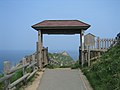 Kamui gate.jpg 1,600 × 1,200; 802 KB
-
 Kamui Rock at Cape Kamui, Hokkaido - Jun 15, 2008 (1).jpg 3,000 × 4,000; 6.89 MB
-
 Kamui Rock at Cape Kamui, Hokkaido - Jun 15, 2008 (2).jpg 4,000 × 3,000; 5.06 MB
-
 P7030384.JPG 960 × 1,280; 272 KB
-
 Radar at Cape Kamui 01.jpg 4,272 × 2,848; 5.93 MB
-
 View from Cape Kamui 20090803.jpg 1,600 × 1,200; 161 KB
-
 View from Cape Kamui, -2010 a.jpg 1,024 × 682; 167 KB
-
 神威岬 - panoramio (1).jpg 2,048 × 1,536; 1.41 MB
-
 神威岬 - panoramio (2).jpg 1,600 × 1,200; 1.13 MB
-
 神威岬 - panoramio.jpg 2,048 × 1,536; 1.29 MB
-
 神威岬(kamuimisaki) - panoramio.jpg 3,000 × 4,000; 4.46 MB
-
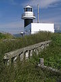
 神威岬-灯台 - panoramio.jpg 3,648 × 2,736; 1.79 MB
-
 神威岬1 - panoramio.jpg 3,648 × 2,736; 2.04 MB
-
 神威岬2 - panoramio.jpg 3,648 × 2,736; 3.45 MB
-
 神威岬2(kamuimisaki) - panoramio.jpg 4,000 × 3,000; 4.64 MB
-
 神威岬3 - panoramio.jpg 3,648 × 2,736; 2.51 MB
-
 神威岬4 - panoramio.jpg 3,648 × 2,736; 2.6 MB
-
 神威岬5 - panoramio.jpg 3,648 × 2,736; 2.34 MB
-
 神威岬(Kamui Cape) - panoramio.jpg 2,048 × 1,232; 1.5 MB
-
 積丹半島のウミネコ7030363.JPG 1,280 × 960; 303 KB
-
 積丹半島の沈船P7030029.JPG 1,280 × 960; 292 KB
-
 積丹半島エゾカンゾウの群落7030311.JPG 1,280 × 960; 271 KB
-
 積丹半島先端7030361.JPG 960 × 1,280; 278 KB
-
 積丹半島全体7030294.JPG 960 × 1,280; 285 KB
-
 積丹半島神威岬より南側を望む7030382.JPG 1,280 × 960; 278 KB
-
 積丹半島神威岬より南側を望む7030383.JPG 1,280 × 960; 250 KB
-
 積丹半島神威岬北側絶壁にはエゾカンゾウが咲き乱れる7030244.JPG 960 × 1,280; 284 KB


.jpg)


.jpg)
.jpg)

_-_panoramio.jpg)


_-_panoramio.jpg)


