Category:Cape Pine lighthouse
 |
This category is for a cultural heritage site in Canada, number 3634
|
This category is for a cultural heritage site in Canada, number 10586
|
| Object location | | View all coordinates using: OpenStreetMap |
|---|
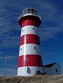
lighthouse in Newfoundland and Labrador, Canada  | |||||
| Upload media | |||||
| Instance of | |||||
|---|---|---|---|---|---|
| Made from material | |||||
| Location | Newfoundland and Labrador, Canada | ||||
| Architect | |||||
| Heritage designation | |||||
| Inception |
| ||||
| Significant event |
| ||||
| Height |
| ||||
 | |||||
English: Cape Pine Light
Media in category "Cape Pine lighthouse"
The following 6 files are in this category, out of 6 total.
-
 GORDON(1863) Lighthouses - CANADA, CAPE PINE.jpg 565 × 1,211; 127 KB
-
 Cape Pine Lighthouse 2.JPG 4,608 × 3,456; 7.37 MB
-
 Cape Pine lighthouse.jpg 3,008 × 2,000; 1.54 MB
-
 Cape Pine Lighthouse.JPG 3,456 × 4,608; 2.4 MB
-
 Cape Pine.jpg 1,952 × 2,576; 1.65 MB
-

_Lighthouses_-_CANADA,_CAPE_PINE.jpg)


.jpg)