Category:Cape Wrath Lighthouse
| Object location | | View all coordinates using: OpenStreetMap |
|---|
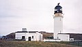
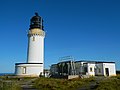
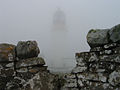
English: Cape Wrath Lighthouse
lighthouse located at the most North-Westerly point of the British mainland, in Sutherland, Scotland  | |||||
| Upload media | |||||
| Instance of | |||||
|---|---|---|---|---|---|
| Location |
| ||||
| Architect | |||||
| Main building contractor | |||||
| Operator | |||||
| Heritage designation |
| ||||
| Inception |
| ||||
| Source of energy | |||||
| Height |
| ||||
 | |||||
Media in category "Cape Wrath Lighthouse"
The following 29 files are in this category, out of 29 total.
-
 Am Buachaille with the Cape Wrath lighthouse in the distance - geograph.org.uk - 2936356.jpg 4,000 × 3,000; 6.23 MB
-
 Cape Wrath from seaward - geograph.org.uk - 344806.jpg 640 × 480; 58 KB
-
 Cape Wrath Lighthouse - geograph.org.uk - 1373795.jpg 640 × 480; 70 KB
-
 Cape Wrath Lighthouse - geograph.org.uk - 1438301.jpg 640 × 427; 59 KB
-
 Cape Wrath lighthouse - geograph.org.uk - 18407.jpg 640 × 368; 48 KB
-
 Cape Wrath Lighthouse - geograph.org.uk - 1972794.jpg 640 × 438; 65 KB
-
 Cape Wrath lighthouse - geograph.org.uk - 2976748.jpg 530 × 800; 91 KB
-
 Cape Wrath Lighthouse - geograph.org.uk - 45625.jpg 435 × 640; 56 KB
-
 Cape Wrath Lighthouse - geograph.org.uk - 604965.jpg 640 × 480; 35 KB
-
 Cape Wrath lighthouse - geograph.org.uk - 815940.jpg 640 × 480; 145 KB
-
 Cape Wrath Lighthouse - geograph.org.uk - 821637.jpg 640 × 405; 181 KB
-
 Cape Wrath Lighthouse - geograph.org.uk - 821647.jpg 432 × 640; 253 KB
-
 Cape Wrath Lighthouse - geograph.org.uk - 821653.jpg 640 × 610; 281 KB
-
 Cape Wrath Lighthouse - geograph.org.uk - 931675.jpg 640 × 480; 39 KB
-
 Cape Wrath Lighthouse - geograph.org.uk - 934462.jpg 640 × 427; 51 KB
-
 Cape Wrath Lighthouse - Mid-1998.jpg 3,104 × 4,443; 5.14 MB
-
 Cape Wrath Lighthouse from SE.jpg 3,850 × 2,819; 890 KB
-
 Cape Wrath Lighthouse, Sutherland (5609013).jpg 1,536 × 2,048; 229 KB
-
 Cape Wrath lighthouse.jpg 368 × 527; 35 KB
-
 CapeWrathFromSeawardByColinWheatleyFeb2007.jpg 632 × 468; 54 KB
-
 CapeWrathLighthouse (15741628825).jpg 4,320 × 3,240; 2.74 MB
-
 Capewrathlighthouse.jpg 640 × 480; 47 KB
-
 CapeWrathLighthouseTop (15739712791).jpg 4,320 × 3,240; 2.94 MB
-
 End of the U70 , Cape Wrath lighthouse - geograph.org.uk - 2976714.jpg 800 × 530; 112 KB
-
 Fog Horn at Cape Wrath Light - geograph.org.uk - 29974.jpg 640 × 480; 87 KB
-
 Lighthouse 1965 (49935273538).jpg 9,930 × 9,913; 8.05 MB
-
-
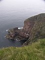 Cliffs beside Cape Wrath Lighthouse - geograph.org.uk - 304505.jpg 480 × 640; 82 KB
-
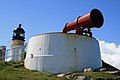 Foghorn at Cape Wrath - geograph.org.uk - 1438305.jpg 640 × 427; 50 KB


.jpg)


.jpg)

.jpg)


.jpg)


