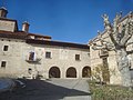
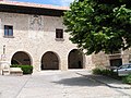
Category:Casa consistorial de Fortanete
This is a category about a monument indexed in the Spanish heritage register of Bienes de Interés Cultural under the reference RI-51-0010728. |
| Object location | | View all coordinates using: OpenStreetMap |
|---|
 | |||||
| Upload media | |||||
| Instance of | |||||
|---|---|---|---|---|---|
| Location | Fortanete, Maestrazgo, Teruel Province, Aragon, Spain | ||||
| Heritage designation | |||||
 | |||||
Media in category "Casa consistorial de Fortanete"
The following 6 files are in this category, out of 6 total.
-
 Ayuntamiento de Fortanete (comarca Maestrazgo, Teruel).jpg 3,072 × 2,304; 2.82 MB
-
 Ayuntamiento de Fortanete, comarca Maestrazgo, Teruel.jpg 3,072 × 2,304; 2.74 MB
-
 Ayuntamiento y Casa Consistorial de Fortanete, comarca Maestrazgo, Teruel.jpg 3,072 × 2,304; 2.78 MB
-
 CasaConsistorial Fortanete.jpg 1,185 × 1,775; 390 KB
-
 CasaConsistorialFortanete.jpg 2,272 × 1,704; 1.23 MB
-
 Lonja Casa Consistorial Fortanete.jpg 1,785 × 1,177; 470 KB
.jpg)


