Category:Catharinastraat 44, Breda
| Object location | | View all coordinates using: OpenStreetMap |
|---|
building in Breda, Netherlands  | |||||
| Upload media | |||||
| Instance of | |||||
|---|---|---|---|---|---|
| Location | Breda, North Brabant, Netherlands | ||||
| Street address |
| ||||
| Located on street | |||||
| Heritage designation |
| ||||
 | |||||
|
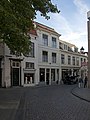
This is a category about rijksmonument number 10138
|
| Address |
|
Media in category "Catharinastraat 44, Breda"
The following 10 files are in this category, out of 10 total.
-
 Breda Catharinastraat42.jpg 2,736 × 3,648; 5.15 MB
-
 Breda Catharinastraat44.jpg 2,736 × 3,648; 4.84 MB
-
 Hoek Catharinastr. - Breda - 20041644 - RCE.jpg 825 × 1,200; 238 KB
-
 Hoek Catharinastr., gevels - Breda - 20041637 - RCE.jpg 1,200 × 821; 187 KB
-
 Inkijk - Breda - 20040909 - RCE.jpg 816 × 1,200; 187 KB
-
 Met Catharinastr. 44 - Breda - 20041638 - RCE.jpg 1,200 × 815; 198 KB
-
 Overzicht - Breda - 20040804 - RCE.jpg 1,200 × 788; 228 KB
-
 Overzicht - Breda - 20040987 - RCE.jpg 823 × 1,200; 197 KB
-
 Overzicht - Breda - 20041581 - RCE.jpg 1,200 × 957; 179 KB
-
 Veemarktstraat - Catharinastr., voorzijde - Breda - 20041584 - RCE.jpg 1,200 × 951; 254 KB


