Category:Château de Hohenfels
| Object location | | View all coordinates using: OpenStreetMap |
|---|
|
This building is inscrit au titre des monuments historiques de la France. It is indexed in the base Mérimée, a database of architectural heritage maintained by the French Ministry of Culture, under the references PA00084671
|
castle  | |||||
| Upload media | |||||
| Instance of | |||||
|---|---|---|---|---|---|
| Location | Dambach, Bas-Rhin, Q22010895, Metropolitan France, France | ||||
| Street address |
| ||||
| Heritage designation |
| ||||
| Inception |
| ||||
 | |||||
Media in category "Château de Hohenfels"
This category contains only the following file.
-
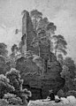 Hohenfels dambach.jpg 731 × 1,016; 484 KB