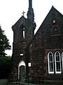
Category:Chaloner Hall
| Object location | | View all coordinates using: OpenStreetMap |
|---|
This is a category about listed building number 1068403. |
building in Grassendale, Liverpool, UK  | |||||
| Upload media | |||||
| Instance of | |||||
|---|---|---|---|---|---|
| Location | Grassendale, Liverpool, Merseyside, North West England, England | ||||
| Heritage designation |
| ||||
 | |||||
Media in category "Chaloner Hall"
The following 5 files are in this category, out of 5 total.
-
 Belfry, Chaloner Hall.JPG 1,920 × 2,560; 392 KB
-
 Chaloner Hall 2017.jpg 4,312 × 3,272; 7.14 MB
-
 Chaloner Hall, Grassendale detail.jpg 2,560 × 1,920; 1.58 MB
-
 Chaloner Hall, Grassendale sign.jpg 1,920 × 2,560; 539 KB
-
 Chaloner Hall, Grassendale.jpg 2,560 × 1,920; 1.25 MB


