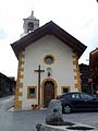
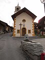
Category:Chapelle St-Michel (Chemin du Ouâ 9, Haute-Nendaz)
| Object location | | View all coordinates using: OpenStreetMap |
|---|
chapel building in Haute-Nendaz in the canton of Valais, Switzerland  | |||||
| Upload media | |||||
| Instance of | |||||
|---|---|---|---|---|---|
| Part of | |||||
| Location | Haute-Nendaz, Nendaz, Conthey District, Valais, Switzerland | ||||
| Street address |
| ||||
| Heritage designation | |||||
 | |||||
Media in category "Chapelle St-Michel (Chemin du Ouâ 9, Haute-Nendaz)"
The following 3 files are in this category, out of 3 total.
-
 Chapelle Saint-Michel du vieux village de Haute-Nendaz.jpg 2,816 × 4,224; 4.55 MB
-
 ChapelleSaintMichel.jpg 1,944 × 2,592; 1.22 MB
-
 Haute Nendaz alte kirche.jpg 1,946 × 2,594; 318 KB

