Category:Chetwynd, Shropshire
civil parish in Shropshire, UK | |||||
| Upload media | |||||
| Instance of | |||||
|---|---|---|---|---|---|
| Location | Telford and Wrekin, Shropshire, West Midlands, England | ||||
 | |||||
Subcategories
This category has the following 5 subcategories, out of 5 total.
P
- Pickstock (2 F)
- Puleston Bridge (4 F)
- Puleston, Shropshire (8 F)
S
- St Luke's, Sambrook (2 F)
Media in category "Chetwynd, Shropshire"
The following 106 files are in this category, out of 106 total.
-

-

-
 A41 at Chetwynd Park - geograph.org.uk - 1829265.jpg 640 × 480; 55 KB
-
 A41 at Lane End Farm - geograph.org.uk - 2775380.jpg 640 × 480; 72 KB
-

-
 A41 at the junctions for Chetwynd - geograph.org.uk - 2775375.jpg 640 × 480; 52 KB
-
 A41 at the turning for Edgmond Marsh - geograph.org.uk - 2775411.jpg 640 × 480; 59 KB
-

-
 A41 near Chetwynd Park - geograph.org.uk - 2775370.jpg 640 × 480; 56 KB
-
 A41 near New House - geograph.org.uk - 2775376.jpg 640 × 480; 47 KB
-
 A41 north of Standford Bridge - geograph.org.uk - 2775417.jpg 640 × 480; 48 KB
-
 A41 north of the A519 roundabout - geograph.org.uk - 2775369.jpg 640 × 480; 48 KB
-
 Back lane from Pickstock - geograph.org.uk - 4255617.jpg 857 × 1,142; 414 KB
-
 Bamford Library - geograph.org.uk - 287094.jpg 640 × 480; 131 KB
-
 Barn and yard at Sambrook - geograph.org.uk - 1925633.jpg 640 × 480; 69 KB
-
 Barns and yard at Chetwynd Grange farm - geograph.org.uk - 5269765.jpg 1,469 × 1,102; 605 KB
-
 Between two A41s - geograph.org.uk - 3896458.jpg 1,142 × 857; 379 KB
-

-
 Chetwynd Grange Farmland - geograph.org.uk - 2338646.jpg 640 × 539; 80 KB
-
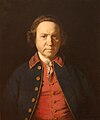 Chetwynd Robert Pigott 1700s.JPG 1,592 × 1,912; 444 KB
-
 Crosshill Lane - geograph.org.uk - 2705899.jpg 640 × 480; 112 KB
-
 Crossroads in Chetwynd Heath - geograph.org.uk - 2775387.jpg 640 × 480; 70 KB
-
 Day tickets available for Howle Pond - geograph.org.uk - 2056145.jpg 613 × 387; 150 KB
-

-
-
 Farmland NE of Edgmond Marsh - geograph.org.uk - 5269781.jpg 1,469 × 1,102; 569 KB
-
 Farmland near Newport - geograph.org.uk - 5951978.jpg 2,592 × 1,944; 1.03 MB
-
 Farmland SE of Chetwynd Grange farm - geograph.org.uk - 5269766.jpg 1,469 × 1,102; 508 KB
-
 Field at Showell Grange - geograph.org.uk - 1925733.jpg 640 × 480; 152 KB
-
 Field boundary near Roman Road - geograph.org.uk - 2706072.jpg 640 × 480; 128 KB
-
 Field edge view from Hinstock Triangulation Pillar - geograph.org.uk - 5230077.jpg 4,000 × 3,000; 4.74 MB
-
 Field north of the Waterloo Road footpath - geograph.org.uk - 5270441.jpg 1,469 × 1,102; 811 KB
-
 Fingerpost at the Flashbrook Crossroads - geograph.org.uk - 5772502.jpg 800 × 495; 117 KB
-
 Flashbrook Crossroads cottages - geograph.org.uk - 4255949.jpg 1,142 × 857; 454 KB
-
 Footpath to Cheneyhill - geograph.org.uk - 3896440.jpg 857 × 1,142; 485 KB
-
 Footpath to Chetwynd - geograph.org.uk - 5270445.jpg 1,469 × 1,102; 552 KB
-
 Footpath towards Chetwynd - geograph.org.uk - 5269789.jpg 1,469 × 1,102; 731 KB
-
 Fork in the road - geograph.org.uk - 4255708.jpg 1,142 × 857; 364 KB
-
 Head of the millpond at Sambrook - geograph.org.uk - 1925679.jpg 640 × 480; 120 KB
-
 Horse paddocks behind Pickstock Manor - geograph.org.uk - 4255610.jpg 1,142 × 857; 369 KB
-
 It's gloomy across Meese valley - geograph.org.uk - 2706069.jpg 640 × 480; 107 KB
-
 Just north of Newport - geograph.org.uk - 2706392.jpg 640 × 480; 74 KB
-

-
 Lane from Puleston towards Pickstock - geograph.org.uk - 4254435.jpg 857 × 1,142; 389 KB
-
 Lane junction on a Roman road - geograph.org.uk - 2030346.jpg 640 × 480; 161 KB
-
 Lane junction on the A41 - geograph.org.uk - 2706048.jpg 640 × 480; 111 KB
-
 Lanes crossing near Pickstock - geograph.org.uk - 1829277.jpg 640 × 480; 56 KB
-
-
 Leaving Sambrook - geograph.org.uk - 2706050.jpg 640 × 480; 120 KB
-
 Manor Farm, Sambrook.jpg 640 × 480; 77 KB
-

-
 New Caynton Mill - geograph.org.uk - 644694.jpg 640 × 480; 97 KB
-
 New House Farm from the south - geograph.org.uk - 5270443.jpg 1,432 × 1,074; 527 KB
-
 NNE from Puleston Hill - geograph.org.uk - 4254422.jpg 1,142 × 857; 492 KB
-
 North side of Puleston Hill - geograph.org.uk - 4254128.jpg 1,142 × 857; 423 KB
-
 North side of Puleston Hill covert - geograph.org.uk - 4254405.jpg 979 × 734; 361 KB
-

-
 OS benchmark - Chetwynd Park wall - geograph.org.uk - 3898836.jpg 857 × 1,142; 605 KB
-
-
 OS benchmark - Pickstock Manor - geograph.org.uk - 4254443.jpg 857 × 1,142; 562 KB
-
 OS benchmark - Pickstock manor cottages stile - geograph.org.uk - 4255656.jpg 857 × 1,142; 549 KB
-

-
 OS benchmark, Chetwynd road - geograph.org.uk - 3898808.jpg 734 × 979; 475 KB
-
 OS benchmark, Chetwynd Road - geograph.org.uk - 3898856.jpg 857 × 1,142; 555 KB
-
 OS benchmark, Chetwynd Road by Park Pool - geograph.org.uk - 3898812.jpg 1,142 × 857; 586 KB
-
 Out of Pickstock towards Sambrook - geograph.org.uk - 4255603.jpg 1,142 × 857; 389 KB
-
 Ovens Bottom - geograph.org.uk - 2706071.jpg 640 × 480; 88 KB
-
 Pickstock - redundant telephone kiosk - geograph.org.uk - 2706067.jpg 640 × 480; 131 KB
-
 Pickstock Manor Farm - geograph.org.uk - 4254438.jpg 1,142 × 857; 388 KB
-
 Protected from the winter - geograph.org.uk - 2706080.jpg 640 × 480; 147 KB
-
 Reflections in the millpond at Sambrook - geograph.org.uk - 1925656.jpg 480 × 640; 120 KB
-
 River Meese - geograph.org.uk - 182374.jpg 480 × 640; 142 KB
-
 River Meese bridge, A41 - geograph.org.uk - 2775412.jpg 640 × 480; 62 KB
-
 Roman Road from Chester to Colchester - geograph.org.uk - 4255760.jpg 1,142 × 857; 330 KB
-
 Roman road near Ellerton - geograph.org.uk - 1925768.jpg 640 × 480; 110 KB
-
 Roman Road near Flashbrook Grange - geograph.org.uk - 5772509.jpg 800 × 551; 125 KB
-
 Sambrook - the way to the church - geograph.org.uk - 2706060.jpg 640 × 480; 133 KB
-
 Sambrook Beck - geograph.org.uk - 1925643.jpg 480 × 640; 174 KB
-
 Sharp bend on the A41 - geograph.org.uk - 2775419.jpg 640 × 480; 50 KB
-
 Showell Mill. - geograph.org.uk - 439749.jpg 640 × 480; 140 KB
-
 South of Camp Farm - geograph.org.uk - 4255724.jpg 857 × 1,142; 405 KB
-
 Southern edge of the woods - geograph.org.uk - 4255951.jpg 979 × 734; 358 KB
-
 Standford Bridge crossroads - geograph.org.uk - 2775416.jpg 640 × 480; 62 KB
-
 Standford Bridge garage, A41 - geograph.org.uk - 2775414.jpg 640 × 480; 54 KB
-
 Summit of Puleston Hill - geograph.org.uk - 4254408.jpg 1,142 × 857; 574 KB
-
 The boundary between field and road (A41) at Buttermilk Hill - geograph.org.uk - 5230082.jpg 4,000 × 3,000; 3.99 MB
-
 The former A41 road into Newport - geograph.org.uk - 3896463.jpg 1,142 × 857; 417 KB
-
 The mill race at Sambrook Mill - geograph.org.uk - 1925667.jpg 640 × 480; 164 KB
-
 The old A41 - geograph.org.uk - 3896431.jpg 979 × 734; 354 KB
-
 The old A41 road - geograph.org.uk - 3896471.jpg 734 × 979; 345 KB
-
 Ticket House Lock - geograph.org.uk - 302631.jpg 640 × 480; 75 KB
-
 Towards Camp Farm - geograph.org.uk - 4255719.jpg 1,142 × 857; 337 KB
-
 Waterloo Road - geograph.org.uk - 5269785.jpg 1,102 × 1,469; 685 KB
-
 A storm a brewing - geograph.org.uk - 6692.jpg 640 × 480; 116 KB
-
 Chetwynd Airfield - geograph.org.uk - 6691.jpg 640 × 480; 91 KB
-
 Chetwynd Forest - geograph.org.uk - 188875.jpg 640 × 480; 162 KB
-
 Deepdale Farm - geograph.org.uk - 597061.jpg 640 × 480; 84 KB
-
 Isolated Cottage. - geograph.org.uk - 6690.jpg 640 × 480; 167 KB
-
 New House Farm. - geograph.org.uk - 425426.jpg 640 × 480; 82 KB
-
 Newport Canal West - geograph.org.uk - 302624.jpg 640 × 480; 45 KB
-
 Sandstone Cottages. - geograph.org.uk - 425429.jpg 640 × 480; 85 KB
-
 Showell Grange. - geograph.org.uk - 433217.jpg 640 × 480; 114 KB
-
 Showell Grange. - geograph.org.uk - 433221.jpg 640 × 480; 99 KB
-
 Showground. - geograph.org.uk - 438048.jpg 640 × 480; 62 KB
-
 Woodland. - geograph.org.uk - 326634.jpg 640 × 480; 125 KB
-
 Woodland. - geograph.org.uk - 442144.jpg 640 × 480; 139 KB


_at_Buttermilk_Hill_-_geograph.org.uk_-_5230082.jpg)


